Walking in the South Downs National Park: a complete planning guide
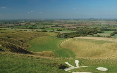
Walk the South Downs on a clear day and the world opens up. Smooth green ridges stretch roughly 90 miles from the white cliffs of Beachy Head near Eastbourne to the tranquil Itchen Valley at Winchester, and in countless places along the way no buildings are visible, only hills and valleys under an immense sky. The highest point is a modest 918ft, but size is beside the point here: this is a cherished landscape, shaped across millennia, loud with skylarks, rich in wildflowers and ancient history, and every bit as beautiful in its own way as bigger hills further north. Walks in the South Downs National Park by Kev Reynolds covers 40 circular day walks throughout the national park, ranging from just under 5 miles to 11 miles, accessible in all seasons and, wherever possible, by public transport. This guide provides everything you need to know to start planning your next walking holiday. (Last updated: June 2026 · Guidebook edition: 3rd edition, May 2024)
Walking in the South Downs National Park, quick facts:
- Location: South Downs National Park, between Eastbourne and Winchester, South East England
- Total routes: 40 circular day walks
- Distance range: just under 5 miles (8km) to 11 miles (17.5km) per walk
- Typical duration: half day to full day
- Difficulty: walks to suit all ages and abilities; no serious difficulties, though some walks include short steep ascents and descents
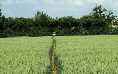
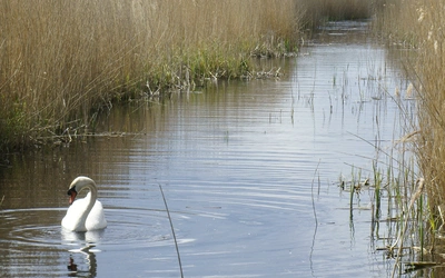
- Terrain: chalk downland, open grassland, ancient woodland, river valleys, coastal cliffs, historic villages
- Highest point: Black Down, 280m (918ft)
- Navigation: 1:50,000 OS map extracts provided for each walk; Explorer 1:25,000 sheets recommended for full detail
- Best season: year-round; spring and early summer for wildflowers and birdsong, winter for clear far-reaching views
- Guidebook: Walks in the South Downs National Park by Kev Reynolds, 3rd edition, Cicerone Press
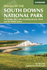
Walks in the South Downs National Park
40 circular day walks including Beachy Head and the Seven Sisters
£14.95
Guidebook with 40 circular walks throughout the South Downs National Park, exploring the beautiful chalk hills between Eastbourne and Winchester. The walks range from under 5 miles to 11 miles, including Beachy Head and the Seven Sisters, Ditchling Beacon and hundreds of prehistoric sites. Accessible all year, but wild flowers best in spring.
More informationWhat is Walks in the South Downs National Park?
Walks in the South Downs National Park is a collection of 40 circular day walks spread throughout the South Downs National Park, covering the full length of these chalk hills from the dramatic headlands near Eastbourne in the east to the quiet downland valleys and villages of the Hampshire Downs near Winchester in the west. Written by Kev Reynolds and now in its third edition, the guide is the product of many years of exploring this landscape in all seasons and all weathers.
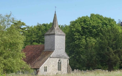
The South Downs are an ample, generous land. Angled slightly inland from the coast, the hills broaden from the narrow ridge above Eastbourne into sometimes heavily wooded parallel ridges further west, while tucked into their folds lie ancient churches, villages of flint and half-timbered brickwork, and historic estates like Firle, Goodwood and Parham that today preserve large areas of unspoilt grassland. There is no wild nature here in the Highland sense; this is a man-made landscape, shaped across millennia, and its history is part of what makes it so rewarding. Neolithic flint mines, Bronze Age barrows, Iron Age hillforts and Roman roads are all present and accessible on foot.
Reynolds makes the case plainly: "Hills are more seductive than plains and valleys, and the South Downs have a subtle beauty that defies comparison with bigger hills and mountains." Size, he argues, plays no part in their attraction. In countless places along these walks no buildings are visible, only hills and valleys under an immense sky, and the solitude that brings is its own reward. This planning guide answers the most common questions walkers have before setting out. For complete route descriptions and mapping, see the Cicerone Walks in the South Downs National Park guidebook.
The 40 routes at a glance
The 40 walks are arranged geographically from east to west, from the coastal headlands near Eastbourne to the quiet Hampshire Downs near Winchester. Each is circular and most are accessible by public transport. The eight walks below represent the highlights of the collection; the full list of 40 routes is in the guidebook.
| Walk | Distance | Why? |
|---|---|---|
| Eastbourne to Birling Gape and East Dean | 9½ miles (15km) | Opens the guide with the full drama of the eastern Downs; Beachy Head and the white cliffs |
| Exceat to East Dean and the Seven Sisters | 8 miles (12.5km) | The classic Seven Sisters cliff walk; one of the most photographed coastlines in England |
| Alfriston to the Long Man of Wilmington | 5 miles (8km) | Visits the mysterious chalk figure cut into the hillside; one of the shorter walks and ideal for a half day |
| Hassocks to the Clayton Windmills and Ditchling Beacon | 10 miles (16km) | Reaches the highest point on the East Sussex Downs, with panoramic views north across the Weald |
| Findon to Cissbury Ring | 7 miles (11km) | Circumnavigates the largest Iron Age hillfort on the Downs, covering 65 acres with traces of a Neolithic flint mine beneath |
| Washington to Chanctonbury Ring | 4¾ miles (7.5km) | The shortest walk in the collection; the ring of beeches on the hilltop skyline is one of the most recognisable landmarks on the South Downs |
| West Stoke to Kingley Vale and Stoughton | 6½ miles (10.5km) | Takes in the ancient yew forest at Kingley Vale, whose oldest trees are among the most ancient living plants in Britain |
| West Meon to Old Winchester Hill and Henwood Down | 9 miles (14.5km) | Explores the finest of the Hampshire Downs, with an Iron Age hillfort and sweeping views across the Meon Valley |
The collection ranges from 4¾ miles (Walk 20, Washington to Chanctonbury Ring) to 11 miles (Walk 11, Glynde to Firle Beacon). Most walks fall comfortably in the 6–8 mile range.

Who are these walks suitable for?
These walks are suitable for walkers of all abilities. Reynolds is explicit that "there's as much enjoyment to be had in a ramble of modest length as may be found in a march that covers 20 miles or more." There are no route-finding difficulties that would challenge a reasonably experienced walker, and the national park's well-maintained path network means that the walks are accessible in all seasons.
Families with children are well catered for at the shorter end of the range, though some routes include stiles, so allow extra time when walking with young children or less experienced companions. Dog walkers will find most routes enjoyable, though some paths are used by livestock, and a handful of routes pass through areas with seasonal ground-nesting birds where dogs must be kept on leads.
Experienced long-distance walkers may find the individual walks modest in length, but the consistent quality of the views, the historical interest, and the opportunities for combining adjacent routes more than compensate.
How difficult are walks in the South Downs?
The South Downs present no serious physical difficulties. The guidebook describes the walks as "suitable for all ages and abilities," and this is broadly accurate. The terrain is predominantly chalk downland, open grassland and woodland paths, and the elevation changes, while sometimes steep on the escarpment's north-facing slopes, are generally short-lived.
The most challenging aspect of some routes is the exposed, open nature of the high downland on windy days: Reynolds notes that "windy days can seem much colder than they really are," and advises carrying warm, windproof clothing even in summer. Navigation is well within the capabilities of most walkers; each route description comes with a 1:50,000 OS map extract, and Reynolds recommends carrying the relevant Explorer 1:25,000 sheet for greater detail.
Footwear needs to be comfortable and, on walks following infrequently used paths where brambles and nettles can encroach, long trousers or overtrousers are advisable. Good walking boots are recommended throughout.
When is the best time to walk in the South Downs?
The South Downs can be walked year-round, and Reynolds is firmly of the view that no season should be overlooked: "every season has its own unique brand of beauty, its own rewards, and a frosty winter's day can hold as much magic for the walker as any in balmy July."
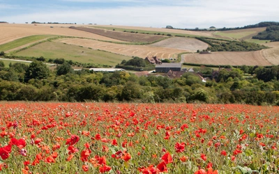
- Spring (April to May): The finest season for wildflowers. Cowslips spread carpets of yellow across open downland, bluebells drift through the ancient woodlands, and orchids appear on the chalk grassland. Skylarks are at their most vocal. Lighter-use paths dry out after winter. The best season for colour and sound.
- Early summer (June to July): Long hours of daylight, warm temperatures, and full growth in field and woodland. Poppies sweep through arable fields in vivid scarlet. The most popular season, so busier car parks at well-known viewpoints.
- Late summer to autumn (August to October): Blackberries ripen along the hedgerows. Migrant birds arrive from northern Europe. Mist in the valleys, golden light on the open ridges. Fieldfare and redwing appear in October. Often the least-crowded period for walking.
- Winter (November to March): Stark, bare-branched trees and long shadows. Views are frequently clearest in this season, with no haze to shorten the horizon. Chalk paths can be slippery after rain or frost; allow more time. The Downs have a particular solitude in winter that some walkers prize above all other seasons.
The guidebook notes that spring and early summer are "best for wild flowers and birdsong," but experienced walkers of this landscape will find every season rewarding.

Getting to the South Downs National Park without a car
Each of the 40 walks begins and ends at the same location, and Reynolds has made public transport access a priority throughout.
Key transport hubs for the eastern section of the park include Eastbourne, Alfriston, Lewes and Seaford. The central section is accessible from Brighton, Hassocks and Worthing. The western Downs and Hampshire section can be reached from Chichester, Petersfield, Arundel and Winchester.
Several railway lines serve the national park directly:
- Brighton to Eastbourne and Lewes (East Sussex walks)
- London to Brighton via Hassocks (central Downs walks)
- London to Chichester and Portsmouth (western Downs walks)
- London Waterloo to Winchester (Hampshire Downs walks)
For specific service information, see the National Rail Enquiries website at www.nationalrail.co.uk or the Traveline bus service at www.traveline.info. The South Downs National Park also provides public transport information at www.southdowns.gov.uk/travelling-around.
For those travelling by car, the grid reference of a suitable car park is given at the head of each walk description. Reynolds advises parking with consideration for local residents, ensuring no obstructions are caused, and avoiding parking near churches during service times.
What accommodation is available near the South Downs?
Accommodation throughout the South Downs National Park ranges from campsites and YHA hostels to B&Bs, pubs with rooms, and hotels. The national park's main towns and villages offer a good spread of options, with key bases including Eastbourne, Alfriston, Brighton, Storrington, Amberley, Arundel, Petersfield, East Meon and Winchester.
For those who prefer not to drive, the public transport connections described above make it practical to base from a larger town and access individual walk starting points by train or bus.
Full accommodation listings are provided in Appendix B of the guidebook. For youth hostel information, contact the YHA via the details in the guidebook's appendices. Independent hostel options for groups, families and individuals are listed in the Handbook of Independent Hostels UK published by The Backpackers Press, or via www.independenthostelguide.co.uk.
Do I need OS maps for these walks?
Each walk in the guide includes a 1:50,000 OS map extract, which Reynolds describes as sufficient "to provide an overview and a general outline of the route." For greater detail and a wider view of the surrounding landscape, he recommends the OS Explorer series at 1:25,000. The specific Explorer sheet numbers are given at the head of each walk description; most sheets cover several walks.
Grid references are used throughout the guide to identify specific positions. Reynolds explains the six-figure grid reference system clearly in the introduction for those unfamiliar with it.
Walks in the South Downs National Park
40 circular day walks including Beachy Head and the Seven Sisters
£14.95
Guidebook with 40 circular walks throughout the South Downs National Park, exploring the beautiful chalk hills between Eastbourne and Winchester. The walks range from under 5 miles to 11 miles, including Beachy Head and the Seven Sisters, Ditchling Beacon and hundreds of prehistoric sites. Accessible all year, but wild flowers best in spring.
More informationPlan your South Downs walks with the Cicerone guidebook
The third edition of Kev Reynolds' Walks in the South Downs National Park contains everything needed to walk all 40 routes with confidence:
- Full route descriptions for all 40 circular walks, from under 5 miles to 11 miles
- 1:50,000 OS map extract for each walk
- Start point grid references and car parking details
- Public transport information for each walk
- Estimated walking times and route summaries
- Notes on refreshments, local pubs and accommodation
- Historical and natural history background throughout
- Appendices covering accommodation listings, useful addresses and a bibliography
Available as a printed guidebook (£14.95) or digital eBook.
About Kev Reynolds, guidebook author
A lifelong passion for the countryside in general, and mountains in particular, drove Kev's desire to share his sense of wonder and delight in the natural world through his writing, guiding, photography and lecturing. Spending several months every year in various high-mountain regions researching guidebooks made him The Man with the World's Best Job.
Kev enjoyed a fruitful partnership with Cicerone from the 1970s, producing 50 books, including guides to five major trekking regions of Nepal and to numerous routes in the European Alps and Pyrenees, as well as walking guides for Kent, Sussex and the Cotswolds. 'A Walk in the Clouds' is a collection of autobiographical short stories recording 50 years of mountain travel and adventures. He was also the contributing editor of the collaborative guide 'Trekking in the Himalaya' and Cicerone's celebratory anniversary compilation 'Fifty Years of Adventure'.
A frequent contributor to outdoor magazines, Kev also wrote and illustrated brochures for national tourist authorities and travel companies. When not away in the mountains, Kev lived with his wife in a small cottage among what he called 'the Kentish Alps', with unrestricted walking country on the doorstep. But he also travelled throughout Britain during the winter months to share his love of the places he wrote about through a series of lectures.
Sadly, Kev passed away in 2021. He will be remembered fondly by all who knew him and by many more he inspired through his writing and talks. Walks in the South Downs National Park has since been updated by Kev's wife, Min.