10 days walking northern Spain’s GR1 - the Sendero Historico
Warwick Sprawson describes his 186km hike along a portion of northern Spain’s GR1, one of the many gran recorrido long-distance trails crossing Europe. They have little idea of what to expect, other than – being late August – it’s going to be hot and, with the trail heading east across the foothills of the Pyrenees, they're going to face some ups and downs, both physically and mentally.
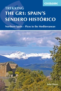
Spain's Sendero Historico: The GR1
Northern Spain - Picos to the Mediterranean
£17.95
Guidebook to the 1250km of Spain's Sendero Historico (GR1), traversing northern Spain from Puerto de Tarna in the province of León in the west to the Mediterranean near L'Escala in Catalonia, through fascinating, varied landscapes and the Pyrenees foothills. Described in 53 stages, about 25km each in length, with detailed mapping.
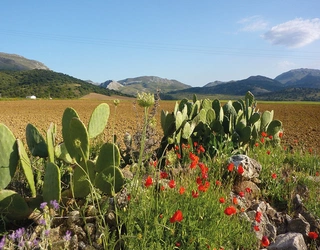
More informationThe towering brick-red cliffs make a spectacular start to the hike. Flat-topped and crowded together like ochre teeth, they dwarf the tiny village of Riglos at their base. Eagles patrol the cliff edge, gliding in the warm updrafts from the plains below. From Riglos we follow quiet farm tracks between olive and almond groves. Yasmin and I feast on the wild figs growing at the edge of the fields. The sun-warmed fruit bursts in the mouth with the taste of honey. Climbing over the first of the foothill’s many north-south ridges, sweat dampening the back of my shirt, we enter an undulating landscape of lavender, rosemary and gorse.
In the early afternoon we follow the GR1’s red and white painted markers through a quiet forest of oak and pine. When the view opens up again we see the village of Loarre, our destination for today, nestled at the base of the hills surrounded by the golden stubble of recently harvested wheat. As we walk towards town, church bells begins tolling as if to mark our arrival.
We leave our packs at a campground and hike up to a crag with a commanding view. Set atop the crag is Loarre Castle, its towers, rampart and keep emerging from the rock like an immense stone crown. Initiated in 1020 by the Sancho the Great, the King of Pamplona, the castle was built on the remains of an old Roman fortress.
The structure marks the former border between the lands of the Moors, who had dominated the Iberian Peninsula since the 8th century, and the smaller Christian kingdoms who held out in the mountainous north.
Our hike follows that border, passing frequent reminders of that fierce struggle to control the peninsula, including numerous ruined Moorish and Christian fortifications.
From the top of the castle the landscape below is set out like a map. The village of Bolea – our destination tomorrow – is visible 11km away, huddled protectively against a wrinkle in the plain. In 1101 a Christian army swept down this hillside to capture Bolea from the Moors. The history seems alive. I can almost hear the clank and clatter of armour. I’m beginning to understand why they call this walk El Sendero Histórico (the historical track): the country’s past emerges from beneath your feet.
The next morning our departure is delayed while I try to repair my sunglasses. Sitting on them had not only proved uncomfortable, but had broken the frames into three pieces. This was a major problem. With the largest village en-route only having a population of a few hundred – and most having a population of a few dozen – there is nowhere to buy another pair. And out here in summer, where the landscape is ablaze in glaring light, sunglasses are essential.
It takes most of a roll of gaffer tape, but the sunglasses are lashed together and held firmly in place with a piece of string. Yasmin surveys the result. ‘Good,’ she says diplomatically. ‘But perhaps don’t wear them while were passing through towns.’ We needn’t have worried about scaring locals with my crazed appearance. There’s no one else around as we tramp out of town between small fields of almonds and wheat. We don’t even see anyone at lunchtime when we eat our ham rolls in the shade of Aniés’ curiously octagonal church tower.
There is nobody in the street, no cars move, even the dogs and birds are silent. Siesta is taken seriously here, especially in summer, with shops shutting and people retreating to their homes from 2 to 5pm. It’s part of a culture that’s changed little in centuries.
Village life still largely revolves around tending small holdings of wheat, almonds, olives and grapes – the same crops grown during Roman times. The houses – built sheer faced against the narrow streets – are stone, with thick lintels, heavy wooden doors and terracotta tiled roofs. During our 10 days on the track we see no other long-distance hikers.
Approaching Bolea there is a cluster of loud bangs and a cheer. In the main plaza locals are busy setting up a stage and seating. The cobblestones are strewn with confetti and the shredded cardboard remains of fireworks. Brawny men toil over a 2m-wide pan full of bubbling broth. They implore us to wait until 10pm when their fardeles, pork meatballs wrapped in stomach lining, will be ready to eat.
Many Spanish villages hold fiestas in late summer, often to celebrate a patron saint. While Bolea might have a population of only a few hundred, the town’s fiesta lasts seven days. The bar – the only place in town open – is packed.
It’s Thursday and the fiesta has been going since Monday, so everyone looks hungover and blurry eyed. The bar staff are too busy to prepare food, meaning we can’t get food anywhere in town until the fadeles are ready. Fatigued from another hot, dusty day we are unlikely to last that long.
Food is one of the chief pleasures of the hike. Even the smallest town generally has a bar-café serving Spanish staples such as tapas, raciones (a large plate of tapas) and bocadillos (lengths of bagette-style roll filled with your choice of jamon – ham – or tortilla Español – the perfect takeaway lunch).
As the few accommodation options in Bolea are full, we reluctantly fill our water bottles and retrace our steps out of town to a secluded patch of oak forest where we set up our tent. Dinner is our emergency food rations: a cold can of chickpeas, some stale bread and chocolate. Even though we are several kilometres from town we don’t miss the fiesta entirely – the music is so loud we can hear the plaza’s bands perfectly.
The next morning we pass through the sleeping town of Bolea and climb into the orange folds of the Sierra de Gratal. It’s a tough, hot climb and we pluck sprigs of wild lavender to place in shirt pockets in an attempt to improve the smell of our clothes. Seven kilometres from Bolea we stop for lunch at a pozo de nieve. Built around 1636, the 4m deep well was used to store snow in winter, the cool depths of the well preserving the precious snow for use in summer.
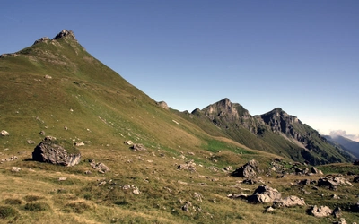
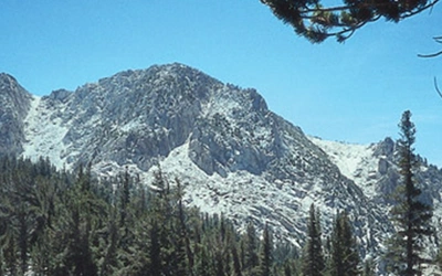
We trundle on, still ascending, until, at 1400m we finally reach a pass over the sierra. It’s been a long 700m climb from Bolea, and as we drop our packs for a rest the wind strips the sweat from our backs. Ahead, like some dramatic theatre backdrop, is the Pyrenees, a massive bulwark of folds and soft peaks in the lilac distance. As I catch my breath I give thanks that we are just sticking to the foothills.
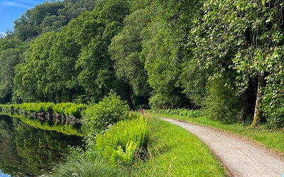
We descend in sun-spangled shade through a magical beech forest, the trees’ trunks a patchwork of lichens and moss. Following a valley towards the town of Arguis, we enter a surreal landscape of grey. Overgrazing has decimated the thin layer of topsoil, exposing the soft scree beneath, which – devoid of vegetation – has eroded into stark runnels and smooth mounds, like a postcard from the moon. In contrast, Arguis is a beautiful trim village bursting with flowers and another great location to spend the night.
The proceeding days certainly deliver the ups and downs expected. Highs include stumbling upon the oasis of the Fulmen River on day 4, a welcome surprise on a day where we were struggling in 38 degree heat. The river plunged down the rocky mountainside in a series of turquoise pools, tinged in gold from the rock’s smooth sandstone base. Diving into a deep thrillingly cold pool was enough to revive me for the rest of the day.
Other highlights were passing through the melancholy remains of abandoned mountain villages. On day 6 we passed through Nazare, Otin, Letusa and Bagüeste, each once a substantial town of several hundred people, now little more than avenues of walls, collapsed stones and heavy wooden beams, all slowly being enveloped by brambles.
Even more poignant were the villages that were only just surviving, the population comprising a handful of stoic old farmers stubbornly eking out a living on the land. In the village of Las Bellostas two of these farmers – men in their 70s – insisted we come into their dim, listing home and share an unlabelled bottle of surprising cool, sweet homemade wine.
A lowlight was getting lost in a rye field just outside the village of Ligüerre de Cinca on day 7. We had taken a ‘shortcut’ to the town which was barely 500m away, but – like a bad dream – we were unable to reach it due to a long, deep ravine at the edge of the field.
After numerous attempts, we ended up having to hike several kilometres around the ravine before looping back. When we finally reached the village they told us that we were mistaken; the campsite we were after was 4km back the way we had just come. We spent that night picking hundreds of sharp rye seeds out of our stinking socks.
Another lowlight was never quite knowing how much water to take each day. While some days featured streams and towns with water fountains, other days were entirely dry. Because we never knew what to expect, we often ended up carrying four litres of water uphill and down dale.
On the last day we follow a beautiful path tracing the curve of the hills. In the early afternoon we take a break at the Castillo de Panillo, a partially collapsed 11th century Christian fort built on the foundations of a Moorish structure, yet another part of the contested border between the two forces.
At 1200 metres in elevation, the circular fort has spectacular views in all directions, including west where our entire route seems laid out before us. As always, we are the only people around. Devotees from the Dag Shang Kagyu temple, a couple of kilometres away, have hung colourful strings of prayer flags which flutter between the pines.
Looking west I think of the layers and layers of history that have settled here, solidifying and washing away like these sedimentary hills; Romans, Moors, Christians and Buddhists, each leaving a rich layer of history to be discovered by anyone who enjoys a few ups and downs.
Warwick Sprawson is the author of Cicerone’s guidebook to Australia’s majestic Overland Track.
Spain's Sendero Historico: The GR1
Northern Spain - Picos to the Mediterranean
£17.95
Guidebook to the 1250km of Spain's Sendero Historico (GR1), traversing northern Spain from Puerto de Tarna in the province of León in the west to the Mediterranean near L'Escala in Catalonia, through fascinating, varied landscapes and the Pyrenees foothills. Described in 53 stages, about 25km each in length, with detailed mapping.
More information