75 years of Britain's national parks: how to explore them on foot
In 1949 the National Parks and Access to the Countryside Act created something that had never existed before in Britain: publicly protected landscapes, preserved in perpetuity for the benefit of everyone. The first two parks were designated in 1951 — the Peak District on 17 April, the Lake District following in May. By the end of that decade Dartmoor, Exmoor, the Yorkshire Dales and Snowdonia had all been designated. The Cairngorms, now the largest national park in Britain, came last, in 2003. Seventy-five years on, those original parks are still the places most walkers think of first when they want to escape into open country. They have been shaped by millennia of geology, farming and human endeavour, and for three quarters of a century they have been protected, walked and loved. Cicerone has been publishing guidebooks to the national parks for decades, and the range we have built covers everything from short, gentle half-day walks to serious winter climbing on the highest ground in Britain. This is our guide to six of them — what makes each one distinctive, why they still matter, and how to explore them on foot.
The Lake District: 75 years of England's adventure capital
The Lake District National Park was designated in May 1951 and celebrates its 75th anniversary this year. It remains, by common consent, the finest fell-walking landscape in England: 2362 square kilometres of volcanic and sedimentary rock, shaped by glaciers, etched with valleys, scattered with tarns and presided over by Scafell Pike, at 978m the highest ground in England.
What makes the Lake District exceptional, and what distinguishes it from every other national park in England, is the combination of high, challenging mountain terrain with intimate valley scenery. The fells rise steeply from wooded valleys and mirrored lakes; ridges connect summit to summit at exhilarating height; the views constantly shift between the local and the vast. As Sir Chris Bonington, who has climbed in the world's greatest mountain ranges, puts it in the foreword to our new edition of Best Walks in the Lake District: "Although I have climbed in many of the world's greatest mountain ranges, however magnificent and high or wild they might have been, I have never found anywhere that compares with the English Lake District."
The park has seen significant changes since it was designated. It now receives a more diverse and younger audience than ever before, a shift the pandemic accelerated. With that has come pressure: the road network was never designed for modern visitor numbers, and the Fix the Fells partnership (a collaboration between the National Trust and the National Park Authority) works constantly to repair and maintain the paths on the most popular routes to Helvellyn, Blencathra, Great Gable and Scafell Pike. Gavin Capstick, CEO of the Lake District National Park Authority, asks walkers to arrive by public transport where possible, park in formal car parks, and consider donating to Fix the Fells.
The best way to mark 75 years is simply to get out on the fells. Cicerone has been publishing Lake District guidebooks for decades, and our range covers every level of walker.
Lead title: Best Walks in the Lake District: 50 Great Mountain Days
The flagship Lake District title in Cicerone's new large-format series. Mark Richards — who began his guidebook writing career in the early 1970s with the direct encouragement of Alfred Wainwright — has selected 50 of the finest mountain days across the full range of Lakeland fells, from the famous summits of Scafell Pike, Helvellyn and Great Gable to quieter and lesser-known ground. Routes range from 6 to 23km and typically take 5 to 10 hours. Each is supported by 1:40,000 Harvey mapping and Mark's distinctive hand-drawn fellscape diagrams, and the book features striking new photography by Grey O'Dwyer. The routes cover the four corners of the national park and are graded for walkers with a reasonable level of fitness and some hillwalking experience.
Also in the range:Walking the Lake District Fells — the eight-volume Fellranger series covering every fell in the national park; Lake District: Low Level and Lake Walks for gentler exploration; 15 Short Walks in the Lake District: Windermere, Ambleside and Grasmere for families and first-time visitors.
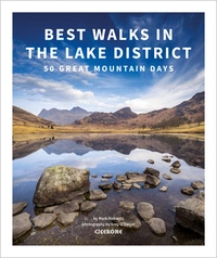
Best Walks in the Lake District
50 Great Mountain Days
£19.95
The 50 best walks in the Lake District, including Scafell Pike, Helvellyn, Skiddaw, Blencathra and other lesser-known but wonderful hill walks. Each route is a Great Mountain Day, a rewarding and potentially challenging route exploring the natural beauty of Lakeland. Includes stunning photography, 1:40,000 Harvey maps and hand-drawn fellscapes for every route.
More informationThe Peak District: Britain's first and most visited national park
The Peak District was designated on 17 April 1951, making it the very first national park in Britain, and it celebrates its 75th anniversary this spring. It covers 1438 square kilometres of the southern Pennines, and is the most visited national park in the country, lying within reach of Sheffield, Manchester, Derby and Nottingham.
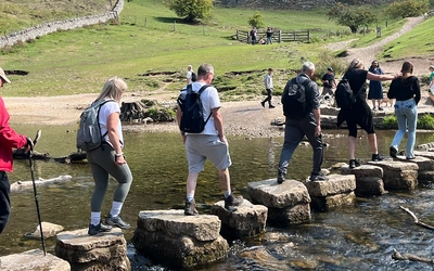
Despite its name, the Peak District is not a landscape of dramatic peaks. It is a place of immense variety and contrast: two very different landscapes in one national park. The Dark Peak to the north is gritstone moorland, brooding and weather-beaten, with blanket bog, peat hags and sweeping ridges. The White Peak, at its heart and in the south, is limestone country — a gentler, more intimate landscape of spectacular dales, sparkling rivers, dry valleys and historic market towns. And the south west corner, where the South West Peak merges into the Staffordshire moorlands, offers a third character entirely: broad belts of high moorland interspersed with gritstone outcrops, cascading reservoirs and the spa town of Buxton, England's highest market town.
The park is one of the most accessible in Britain for first-time or occasional walkers. You can escape the honeypot sites of Dove Dale or Chatsworth in minutes, and even at the height of summer, you don't need to walk far to find solitude. The guidebook for our new short walks title notes that "exploring on foot is not just one of the most rewarding ways to discover the Peak District, it's also the most sustainable" — important in a park covering 955 square miles but receiving around 13 million visitors a year.
Lead title: 15 Short Walks in the Peak District: Buxton, Dove Dale and the South West Peak
Fifteen accessible circular walks in the south west corner of the national park, with no challenging terrain or complicated navigation. Routes range from a leisurely circuit of Buxton's leafy country park to more adventurous outings exploring the River Dove, the Manifold valley and the distinctive gritstone outcrops of the Roaches. Easy-to-read OS maps and clear route descriptions make these walks ideal for families, beginners and anyone wanting to discover what this corner of the Peak District has to offer. Each includes information on beauty spots and refreshment stops.
Also in the range:Walking in the Peak District: Dark Peak for moorland and gritstone walking; Scrambles in the Dark Peak for more adventurous days out; The Pennine Way for long-distance walkers passing through the northern park.
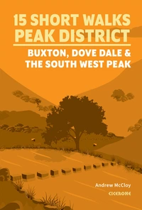
15 Short Walks in the Peak District - Buxton, Dove Dale and the South West Peak
£9.95
Discover 15 of the best short walks around Buxton, Dove Dale and the South West Peak in the Peak District. Each walk comes with easy-to-read Ordnance Survey maps, clear route description and lots of images, plus information on local beauty spots and tasty refreshment stops. No challenging terrain or complicated navigation means walks can be enjoyed by everyone.
More informationDartmoor and Exmoor: Devon's two great moorlands
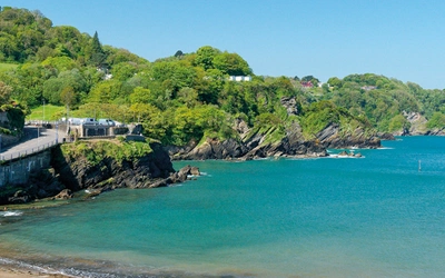
Devon is unique among English counties in having two national parks. Dartmoor, designated in 1951 and the larger of the two, is a raised granite plateau rising to 621m at High Willhays. Exmoor, designated in 1954, covers the north Devon and Somerset coast and a softer moorland interior of folded sedimentary rock, deep combes and wooded river valleys.
Together they form the backbone of Devon's walking landscape with the same geology that gave rise to the Two Moors Way, which crosses both in a single 188km coast-to-coast route. But they are strikingly different in character and reward different kinds of walking.
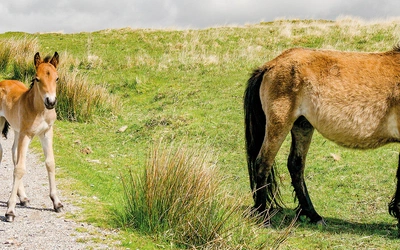
Dartmoor is the more dramatic and more demanding. The granite plateau is studded with Bronze Age hut circles, stone rows and ceremonial structures — nowhere in England has a greater concentration of Bronze Age sites. Medieval tin-working pits and gullies are visible across the moor, and the semi-wild Dartmoor ponies, whose numbers have fallen from 30,000 in the 1950s to around 1,500 today, roam the commons. The weather is formidable: Princetown, Dartmoor's highest settlement, records roughly double the annual rainfall of Plymouth, 15 miles away. In mist, the high moor is wild and demanding. In sunshine, it is one of the finest landscapes in England.
Exmoor is softer and more varied. Folded sandstones and shales produce smooth, rounded moorland slopes, carved by rivers running through steep-sided combes. The coastline is extraordinary: Exmoor's sea cliffs are the highest in England, and the views from the cliff tops of the East Lyn valley are among the finest on any long-distance route in the country. Red deer are present in their greatest numbers in England on Exmoor, at around 3,000 animals, and the pure-bred Exmoor pony, now an endangered species, is found on the moor above Tarr Steps and Winsford Hill.
Dartmoor is also the only place in England where wild camping (when backpacking) is permitted, under an agreement with certain landowners. This makes it a genuine destination for multi-day backpackers in a way that most English national parks are not.
Lead title: Walking the Dartmoor Way
A 175km (109-mile) waymarked circular route around the edge of Dartmoor National Park, described in 10 stages. Rather than crossing the high moor, the Dartmoor Way circles it, dipping into beautiful wooded valleys, passing ancient farmsteads and attractive moorland-edge towns and villages, and giving walkers panoramic views of the granite mass they are circumnavigating. The route takes in the Teign Gorge, Haytor, Castle Drogo, Ivybridge, Tavistock and Okehampton. Written by Sue Viccars, who also wrote Cicerone's Two Moors Way guidebook, the book includes wild camping information, public transport details and a High Moor Link option that allows walkers to create two shorter circular routes.
Also in the range:Walking on Dartmoor for day walks within the park; The Two Moors Way for walkers who want to cross both parks coast-to-coast in one continuous journey.
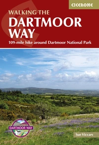
Walking the Dartmoor Way
109-mile hike around Dartmoor National Park
£16.95
Guide to the Dartmoor Way, a waymarked 175km (109 mile) circular walking route around the edge of Devon's beautiful Dartmoor. Presented in 10 stages (plus the High Moor Link which can be used to create two shorter loops), the route takes in wooded valleys, sparkling streams, moorland, farmland and attractive towns and villages.
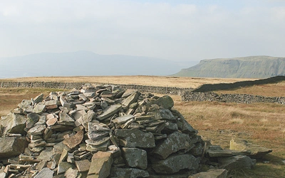
More informationThe Yorkshire Dales: limestone, moorland and the backbone of England
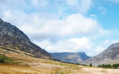
The Yorkshire Dales National Park was designated in 1954, the seventh of Britain's national parks. It covers 2178 square kilometres of the central Pennines ("the backbone of England") and was extended in 2016 to include the Howgill Fells, Mallerstang and the western outlying hills, increasing its area by almost a quarter.
The Dales are named after their most low-lying elements: the long, deep valleys carved by rivers whose names — Swale, Ure, Nidd, Wharfe, Aire, Ribble — are some of the oldest in England. It is this combination of high, open moorland and intimate valley that makes the Yorkshire Dales exceptional. The summits are not dramatic pinnacles but broad-backed ridges and flat-topped fells; the valleys are intricate, walled and farmed, with a visual harmony between built environment and landscape that takes generations to achieve.
The geological variety is exceptional. Great Scar Limestone dominates the south west of the park, producing the spectacular karst scenery of Malham Cove, Gordale Scar and Gaping Gill; towering white cliffs, disappearing rivers, limestone pavements, potholes and cave systems. Further north, the Yoredale Series (named after the River Ure in Wensleydale) creates the stepped terracing characteristic of the northern fells. The Yorkshire Three Peaks — Pen-y-ghent, Whernside and Ingleborough — rise above the head of Ribblesdale, each flat-topped and steep-sided, collectively the subject of one of England's best-known walking challenges.
Around 9.5 million people visit the Yorkshire Dales each year, but the resident population is below 24,000. Even on a bank holiday weekend, wander away from the main centres and you can spend a day on the tops with hardly a soul in sight.
Lead title: Walking in the Yorkshire Dales: South and West
The first of a two-volume set covering the full national park, this book describes 44 walks in the southern and western Dales, covering Wharfedale, Littondale, Malhamdale, Ribblesdale and Dentdale. Routes range from 3.5 to 13 miles, with shorter valley and hillside walks for gentler days and more demanding upland routes for those wanting to explore the high moors. The book includes the famous 23-mile Three Peaks circuit over Pen-y-ghent, Whernside and Ingleborough. Each walk is accompanied by background information on the features encountered along the way.
Also in the range:Walking in the Yorkshire Dales: North and East covering Swaledale, Wensleydale and the eastern dales; The Dales Way for long-distance walkers; Walks in the Yorkshire Dales for a broader selection.
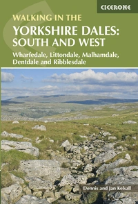
Walking in the Yorkshire Dales: South and West
Wharfedale, Littondale, Malhamdale, Dentdale and Ribblesdale
£14.95
Part of a 2-book set, this guidebook describes 44 walks in the southern and western Yorkshire Dales, including the famous 23 mile Three Peaks circuit over Pen-y-Ghent, Whernside and Ingleborough. The other, mostly circular routes of 3½ to 13 miles cover the scenic region between Sedbergh, Kirkby Lonsdale, Settle, Skipton and Grassington.
More informationSnowdonia/Eryri: the finest mountain walking in Britain
Snowdonia was designated in 1951 and renamed Eryri — its Welsh name, meaning "the highlands" — in 2023. It covers 2132 square kilometres of North Wales, and has a straightforward claim: it offers the finest mountain walking in Britain. The only serious challengers for that distinction, as our guidebook acknowledges, are the Scottish Highlands and the English Lake District, and Snowdonia/Eryri contrives to combine the best features of both.
The mountains of the northern park are big and raw-boned: armour-plated with sweeps of naked stone, embossed with crags, scarred by deep rocky cwms where glaciers took huge bites from their flanks. Jagged ridges set scramblers' pulses racing. Sharp, spiky summits demand respect. Fifteen peaks above 3,000ft, the 3000ft Peaks of Snowdonia, are crammed into the northern sector. Yet like the Lakeland fells, they are closely packed around intimate valleys, lend themselves to satisfying horseshoes and high-level traverses, and are sufficiently close to the major population centres of northern England and the Midlands to be accessible for a weekend.
The diversity of the landscape is exceptional. Snowdon itself — Yr Wyddfa in Welsh — is the highest mountain in England and Wales at 1085m, and its famous Horseshoe route, starting on the knife-edge of Crib Goch, is unrivalled as the park's most celebrated and most challenging short walk. The Glyderau to the north are huge, crag-girt fortresses that rival Snowdon in their rocky challenges. The Carneddau appear at first glance to be massive grassy mounds but conceal some of the national park's most impressive and least frequented crags. To the south, the heights diminish — Cadair Idris at 893m is just 71 feet below the 3000ft mark — but the mountains lose nothing of their character, and each range (the Moelwyns, the Rhinogs, the Arans, the Arenigs and the Tarrens) has its own appeal.
The geology is equally varied: the volcanic rocks that form the great peaks of the north, the sedimentary deposits that gave rise to the vast slate quarries of Llanberis and Blaenau Ffestiniog, and the gritstone outcrops of the Rhinogs that seem more at home in the Peak District. The Welsh language, spoken as a living first language across much of the national park, adds an extra dimension to the sense of place that no other national park in Britain can match.
Lead title: Mountain Walking in Snowdonia
Forty of Snowdonia's finest day walks, covering the full range of the national park from Snowdon and Tryfan in the north to Cadair Idris in the south. Routes range from straightforward mountain walks to Grade 1 scrambles including Crib Goch and Bristly Ridge, and the book includes details of a two-day traverse of all 15 of Snowdonia's 3000ft peaks. Written by Terry Fletcher, the guidebook covers classic routes including the Snowdon Horseshoe, Y Garn, the Rhinogs and routes across the Carneddau, giving walkers both the famous routes and quieter corners of a national park that rewards those who venture off the beaten track.
Also in the range:Hillwalking in Snowdonia for a broader selection of routes; Scrambles in Snowdonia for those wanting more technical days out; The Snowdonia Way for a multi-day traverse of the national park.
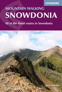
Mountain Walking in Snowdonia
40 of the finest routes in Snowdonia
£16.95
Guidebook to 40 of Snowdonia's best day walks, with routes up Snowdon and Tryfan, including the Snowdon Horseshoe, Cadair Idris, Y Garn and The Rhinogs. The routes range from Grade 1 scrambles like Crib Goch or Bristly Ridge, to riverside and forest walks. Includes details of a 2-day traverse of all 15 of Snowdonia's 3000ft peaks.
More informationThe Cairngorms: Britain's largest national park and its most demanding mountain terrain
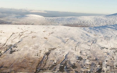
The Cairngorms National Park was designated in 2003, the last of Britain's national parks to be created and by far the largest, covering 4528 square kilometres of the eastern Scottish Highlands. It is home to five of the six highest mountains in Britain, the largest area of Arctic-alpine habitat in the UK, and some of the most demanding and most rewarding mountain terrain on these islands.
The Cairngorm plateau is a high, wind-scoured landscape unlike anything found in the national parks further south. Summits rise above 1200m into genuinely sub-arctic conditions; the plateau itself is vast, featureless in mist, and can be lethal in winter. The corries that bite into the flanks of Cairngorm, Braeriach and Ben Macdui — Coire an t-Sneachda, Coire an Lochain and the magnificent Coire Bhrochain — hold snow well into summer and some of the finest winter climbing routes in Britain. Lochnagar, the great corrie above Royal Deeside, is one of the icons of Scottish mountaineering.
In summer the Cairngorms offer exceptional hill walking and backpacking, with long ridges connecting high summits, ancient pine forest in the straths below and a wildlife population that includes red squirrel, capercaillie, Scottish wildcat, golden eagle and osprey. The Cairngorms also hold one of Scotland's largest red deer populations.
But the Cairngorms are most distinctively themselves in winter. Conditions between November and April transform the mountains into a world-class winter climbing venue. The Northern Corries of Cairngorm are among the most accessible serious winter climbing crags in Britain, reachable from the car park in under an hour, while the remote crags of Beinn a'Bhuird, Braeriach and Creag Meagaidh offer routes that rank among the finest in the world. Good climbing conditions can occur any time between November and April, with February and March tending to be the most reliable months. The weather can change with startling suddenness, and the mountains should never be underestimated.
Lead title: Winter Climbs in the Cairngorms
The definitive guide to winter climbing in the Cairngorms and Creag Meagaidh, covering hundreds of routes from straightforward snow gullies to Grade VII mixed climbs. Written by Blair Fyffe and describing routes across every major crag, from the accessible Northern Corries to the remote and serious cliffs of Lochnagar, Creag an Dubh Loch and Shelter Stone, the book includes topo diagrams, approach maps and clear route descriptions. Routes are classified by area and style, helping climbers choose according to weather and conditions. The guide includes a detailed section on reading and predicting Cairngorms winter conditions, which are more complex and variable than in any other UK mountain area.
Also in the range:Walking in the Cairngorms for summer hill walking and backpacking; Scotland's Mountain Ridges for multi-day ridge routes; Cycling in the Cairngorms for the park's exceptional mountain biking.
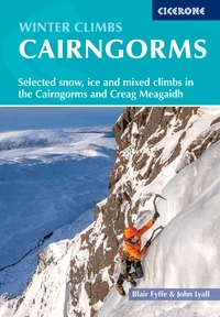
Winter Climbs in the Cairngorms
Selected snow, ice and mixed climbs in the Cairngorms and Creag Meagaidh
£25.00
Guidebook with topo diagrams, approach maps and clear route descriptions for hundreds of Scotland's best winter climbs in the Cairngorms and Creag Meagaidh. Contains a wide selection of grades, lengths and styles of climb, from straightforward snow gullies to mixed turf, rock and icy routes and advanced ice climbs. Routes are classified by area and style, helping climbers choose according to...
More informationWhy national parks still matter
The 1949 Act that created Britain's national parks was born of a vision of open country as a right rather than a privilege: places where anyone could walk freely, breathe clean air, and experience a landscape not dominated by industrial development. John Dower, whose 1945 report laid the groundwork for the legislation, described the purpose of a national park as preserving and enhancing the area's natural beauty and promoting public enjoyment of it.
Seventy-five years on, that dual purpose is more important than ever. Britain's national parks are not wilderness — they are lived-in, farmed, managed landscapes, and the tension between conservation, recreation, and the livelihoods of those who live and work in them is constant. But they remain the places where most people in Britain have their first real encounter with wild country, where children grow up understanding what the natural world looks and sounds like, and where the demands of everyday life feel genuinely far away.
Cicerone has been part of that story for decades. From the first Lakeland guidebooks to the most recent short walks titles, we have been helping walkers find their way into these landscapes, discover less-visited corners, and return safely. The parks change as paths are rerouted, huts open and close, footbridges are washed away and rebuilt, but our guidebooks always change with them.