St Oswald's Way: a complete planning guide
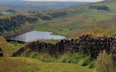
Stand on the craggy sandstone summit of the Simonside Hills, and on a clear day the whole of the Northumberland coast unfolds before you, drenched in mauve and gold. That view is a fitting introduction to St Oswald's Way, one of England's finest and least-walked long-distance trails: 100 miles (161km) of rolling farmland, rugged heather moorland, vast sandy beaches and dramatic coastal dunes, linking Heavenfield near Hadrian's Wall to Holy Island (Lindisfarne). Most walkers continue to Berwick-upon-Tweed on the final stage of the Northumberland Coast Path, bringing the total to 111½ miles (179.5km) across 7–8 days. The companion Northumberland Coast Path (71½ miles/115km) can be completed in 5–6 days. (Last updated: May 2026 · Guidebook edition: First edition, June 2023)
St Oswald's Way & Northumberland Coast Path quick facts:
- Distance: 111½ miles (179.5km) including Holy Island to Berwick-upon-Tweed; 100 miles (161km) to Holy Island only. Northumberland Coast Path: 71½ miles (115km)
- Duration: 7–8 days (St Oswald's Way); 5–6 days (Northumberland Coast Path)
- Start: Heavenfield (St Oswald's Way); Cresswell (Northumberland Coast Path)
- Finish: Berwick-upon-Tweed (both routes, as recommended)
- Stages: 7 stages (plus an optional 8th to Berwick-upon-Tweed); NCP shares Stages 4–7 of SOW
- High point: Coquet Cairn, just over 300m; Simonside Hills
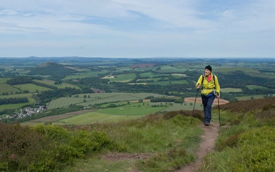
- Difficulty: Easy. No technical or exposed sections
- Terrain: Farmland, heather moorland, sandstone crags, coastal dunes and beaches
- Waymark: St Oswald's Way: raven badge with Northumberland shield. Northumberland Coast Path: North Sea Trail blue 'N' and England Coast Path acorn
- Accommodation: B&Bs, inns and small hotels throughout; limited camping
- Best season: May to August; good birdwatching October to November
- Guidebook:Walking St Oswald's Way and Northumberland Coast Path by Rudolf Abraham, 1st edition (Cicerone, 2023)

Walking St Oswald's Way and Northumberland Coast Path
Heavenfield and Cresswell to Holy Island
£16.95
Guide to St Oswald's Way, stretching 97 miles (156km) through Northumberland from Heavenfield near Hadrian's Wall, to Holy Island (Lindisfarne) and taking in almost the whole length of the Northumberland Coast AONB. Includes an option to continue to Berwick-upon-Tweed on the final stage of the Northumberland Coast Path.
More information
What is St Oswald's Way?
St Oswald's Way is a 100-mile (161km) long-distance trail that traverses Northumberland from Heavenfield, near Hadrian's Wall, to Holy Island (Lindisfarne) on the Northumberland coast, opened in August 2006. Its route links sites associated with the life of St Oswald, the seventh-century Anglo-Saxon king who played a decisive role in bringing Christianity to northern England: the battlefield at Heavenfield where he won his kingdom, his capital at Bamburgh, and the priory at Holy Island where St Aidan settled at his invitation in 635AD. Walking the route is, in a quiet way, a journey through the foundations of English Christianity.
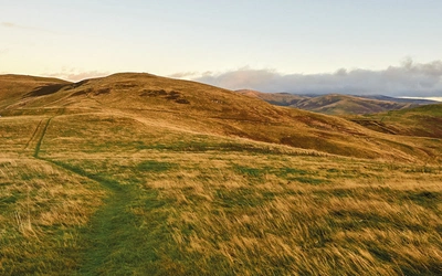
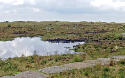
The landscapes the trail passes through are as diverse as the history it explores. From Hadrian's Wall, the route crosses rolling farmland and rises onto the fell sandstone and heather moorland of the Simonside Hills in Northumberland National Park, before descending to the coast and tracing almost the entire length of the Northumberland Coast AONB from Warkworth to Berwick-upon-Tweed. Enormous sandy beaches, dramatic castle-crowned headlands and rich birdlife make the coastal section a spectacular finale. For comparison, think of it as England's answer to a Scottish coastal pilgrim route, but with better weather, less ascent and arguably finer castles.
Despite all this, St Oswald's Way sees remarkably few walkers. Northumberland National Park has the lowest population density and some of the lowest visitor numbers of any national park in England and Wales. That is both a great pity and, for those who do come, one of its greatest charms. The companion Northumberland Coast Path (71½ miles/115km, Cresswell to Berwick-upon-Tweed) shares most of its route with St Oswald's Way from Warkworth onward, so this single Cicerone guidebook covers both trails in full. This planning guide answers the most common questions walkers have before setting out. For complete stage-by-stage route descriptions and mapping, see the Cicerone Walking St Oswald's Way and Northumberland Coast Path guidebook.
What is the Northumberland Coast Path, and how does it differ from St Oswald's Way?
The Northumberland Coast Path is a 71½-mile (115km) coastal trail running from Cresswell, on the southern edge of the Northumberland Coast AONB, to Berwick-upon-Tweed. It can be completed comfortably in 5–6 days. The two routes share the same path from Warkworth all the way to Berwick-upon-Tweed, covering the entirety of the stunning Northumberland coastline. The NCP has two unique stages of its own: the opening stretch from Cresswell to Warkworth (10½ miles/16.5km), and the final leg from Holy Island to Berwick-upon-Tweed (11½ miles/18.5km).
The practical difference is straightforward. St Oswald's Way is the longer, more varied route: it begins at Hadrian's Wall, crosses farmland and climbs onto the heather moorland of Northumberland National Park before reaching the coast, and its historical thread (following the journey of St Oswald and the early Christian church) gives it a strong narrative spine. The Northumberland Coast Path is an entirely coastal walk, staying close to the shoreline from start to finish, with no significant inland or upland sections and a slightly lower daily mileage on most stages.
Choose St Oswald's Way if you want the full Northumberland experience: inland hills, national park, the geological drama of the Whin Sill, Neolithic rock art at Lordenshaws, and a week-long journey with a strong sense of purpose and place. Choose the Northumberland Coast Path if you want to focus on the coast, prefer a shorter overall distance, or are working within a tighter schedule. Both routes finish at Berwick-upon-Tweed and both are covered in full by this single Cicerone guidebook.
How long is St Oswald's Way?
St Oswald's Way covers 111½ miles (179.5km) over 7 stages, with a recommended 8th stage continuing from Holy Island to Berwick-upon-Tweed along the Northumberland Coast Path. The Northumberland Coast Path runs 71½ miles (115km) over 6 stages (sharing Stages 2–5 with SOW Stages 4–7).
St Oswald's Way
| Stage | Route | Distance | Time |
|---|---|---|---|
| 1 | Heavenfield to Kirkwhelpington | 17½ miles (28.5km); 19 miles (31km) from Wall | 8hrs 15mins |
| 2 | Kirkwhelpington to Rothbury | 15 miles (24km) | 6hrs |
| 3 | Rothbury to Warkworth | 18 miles (29km) | 8hrs |
| 4 | Warkworth to Craster | 13½ miles (21.5km) | 5hrs 20mins |
| 5 | Craster to Bamburgh | 14 miles (22km) | 5hrs |
| 6 | Bamburgh to West Mains | 14½ miles (23.5km) | 7hrs |
| 7 | West Mains to Holy Island | 7½ miles (12km) | 2hrs 45mins |
| (+8) | Holy Island to Berwick-upon-Tweed (NCP Stage 6) | 11½ miles (18.5km) | 5hrs 30mins |
Northumberland Coast Path (unique stages)
| Stage | Route | Distance | Time |
|---|---|---|---|
| 1 | Cresswell to Warkworth | 10½ miles (16.5km) | 3hrs 30mins |
| 6 | Holy Island to Berwick-upon-Tweed | 11½ miles (18.5km) | 5hrs 30mins |
Stage 3 (Rothbury to Warkworth, 18 miles/29km) is the longest and most demanding, crossing the heather moorland of the Simonside Hills. Stages 1 and 2 have no intermediate accommodation, so it is important to reach Kirkwhelpington and Rothbury as planned on those days.

Who is St Oswald's Way suitable for, and how difficult is it?
St Oswald's Way is rated easy. There are no technical difficulties, no scrambling and no high-level or exposed ridge sections. Both the trail itself and the Northumberland Coast Path are well waymarked, and public transport to the main start and finish points is straightforward throughout the year.
That said, some stages are long: Stage 3 at 18 miles (29km) and Stage 6 at 14½ miles (23.5km) are full days on the hill for most walkers. The crossing of the Simonside Hills on Stage 3 can present navigation challenges in low cloud or poor visibility, and can be exposed to strong winds. Stiles along the route can be steep.
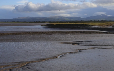
The one genuinely unusual difficulty is the tidal crossing to Holy Island. Crossing the sands on foot from the mainland to Holy Island requires careful timing: allow at least 1 hour (some advise up to 2 hours if the sand is soft), and aim to complete the crossing by the midpoint of the safe crossing period. Crossing in the dark is not advised. Safe crossing times are published by Northumberland County Council and displayed clearly at the causeway entrance.
Walkers of average fitness with experience of multi-day walking in the British lowlands will find both routes very manageable. Less experienced walkers should plan rest days and consider breaking the longer stages, with stopping points at Alnmouth, Boulmer, or Felton on Stage 3/4 offering shorter alternatives.
Can I walk a shorter section of St Oswald's Way?
Yes, and the route lends itself well to this. From Rothbury northward to Berwick-upon-Tweed, there are plentiful accommodation options and good bus access throughout, making it easy to walk the trail in shorter bites. A few practical options:
- The coastal section only (Warkworth to Berwick-upon-Tweed, SOW Stages 4–7 plus NCP Stage 6): around 57 miles (92km), 4–5 days. This covers the entire Northumberland Coast AONB and takes in Dunstanburgh Castle, Bamburgh, the Farne Islands and Holy Island. Excellent train access at Alnmouth and bus services along the coast.
- The Northumberland Coast Path (Cresswell to Berwick-upon-Tweed, 71½ miles/115km): a 5–6 day walk taking in the full coastal AONB and starting at the more southerly village of Cresswell.
- The inland and national park section (Heavenfield to Rothbury, SOW Stages 1–2):32½ miles (52.5km), 2 days, covering Northumberland National Park, the Simonside Hills and some of the route's richest historical and geological interest.
Which direction should I walk St Oswald's Way?
The standard, official route description runs from east to west: Holy Island to Heavenfield. This guidebook reverses that direction, describing the route from west to east (Heavenfield to Holy Island), for one straightforward reason: the Northumberland coast and Holy Island make a spectacular finale, and the idea of following a route towards the sea is, as the author puts it, irresistible.
The west-to-east direction is recommended here. Finishing at Berwick-upon-Tweed (rather than Holy Island) also gives far better onward transport connections.

When is the best time to walk St Oswald's Way?
Both St Oswald's Way and the Northumberland Coast Path can be walked at any time of year, though each season brings its own character.
- May to July: The best overall window. Weather is generally at its finest, with the most sunshine hours. Seabirds are at their most spectacular on the Farne Islands, and wildflowers are in bloom along the coast. Accommodation is available throughout but should be booked well in advance, especially on the coast.
- August: Heather moorland is at its most beautiful in full bloom on the Simonside Hills. The most popular month, and booking ahead is essential. Note that August is also the start of the grouse season (running to December), when some hotels may be booked by shooting parties.
- September to October: An excellent shoulder season. Autumn colour in the deciduous woodland, and the arrival from mid-October of winter migrant birds at Lindisfarne National Nature Reserve and Fenham Flats.
- October to November: Exceptional birdwatching at Fenham Flats and Budle Bay, where internationally important flocks of pale-bellied Brent geese, pink-footed geese, wigeon and grey plover gather. Grey seals have their pups on the Farne Islands from late October.
- December to March: Quieter and often atmospherically beautiful, particularly in snow. Some B&Bs and visitor attractions (including Lindisfarne Priory and Warkworth Castle) close or operate reduced hours. Heavy snowfall can close roads and obliterate trails in the hills.
What accommodation is available on St Oswald's Way?
Accommodation along the route is provided by a good range of B&Bs, inns and small hotels, many of them excellent. Some B&Bs offer evening meals and packed lunches by prior arrangement; otherwise a decent pub or inn is usually close by.
There are a few important practical notes:
- Stages 1 and 2 (Heavenfield/Wall to Rothbury): There is no accommodation at intermediate points between Hadrian's Wall and Knowesgate, or between Knowesgate and Rothbury. These two stages must be walked in full.
- From Rothbury onward: Shorter stages become possible at Weldon Bridge, Felton, Alnmouth, Boulmer and elsewhere, with plenty of accommodation options.
- Holy Island: Prices on Holy Island are generally higher than elsewhere on the coast, and many places require a minimum three-night stay.
- Camping: Somewhat limited. Camping is prohibited in Northumberland National Park, and there are few campsites on the main routes except along the northern coast.
It pays to book well in advance throughout, and especially on the coast in summer, where some stages have only a small number of accommodation options. Full listings are given in Appendix C of the guidebook.
How do I get to the start of St Oswald's Way?
Access to both routes by public transport is straightforward, and the guidebook actively discourages driving to the start: as point-to-point routes, leaving a car at the trailhead means returning by public transport to collect it.
By train: The East Coast Main Line (LNER) calls at Newcastle and Berwick-upon-Tweed, with some services stopping at Alnmouth. Northern Rail runs between Carlisle and Newcastle, calling at Hexham.
Getting to Heavenfield (SOW start): Take the train to Hexham (from Newcastle or Carlisle), then the 680 or 880 bus to Wall, from where it is 1½ miles (2.5km) to Heavenfield. The AD122 Hadrian's Wall Bus (early April to late September) also serves the area.
Getting to Cresswell (NCP start): Take the X20 bus from Newcastle to Ellington, then a 20-minute walk to Cresswell.
Along the route: The X18 bus (Newcastle to Berwick-upon-Tweed via the coast) serves Alnmouth, Craster and Bamburgh, making it easy to join or leave the route mid-walk. The 477 bus (Wednesday and Saturday only) connects Holy Island to Berwick-upon-Tweed.
Always check current timetables with individual operators or at the Northumberland County Council transport pages, as services and providers can change.

Is there a passport or certificate scheme for St Oswald's Way?
Yes, both routes offer completion certificates, and the process for each differs slightly.
For St Oswald's Way, walkers can apply for a certificate after completing the route, but must purchase a certificate pack in advance from the St Oswald's Way website. The pack includes a sheet for making rubbings from the raised motif on six information panels found at points along the route, which serve as proof of completion.
For the Northumberland Coast Path, a passport booklet must be obtained in advance from northumberlandcoastpath.org, and stamped at locations along the route. A certificate is then available on completion.
What is the Holy Island tidal crossing, and how do I plan for it?
Crossing to Holy Island on foot across the sands is one of the most memorable moments on St Oswald's Way, and one that requires careful planning. The crossing is only possible during specific windows around low tide, published in advance by Northumberland County Council (search 'Holy Island causeway safe crossing times' at northumberland.gov.uk) and displayed clearly at the causeway entrance.
Allow at least 1 hour for the crossing from the first refuge box at South Low to Chare Ends on Holy Island (a distance of just over 2½ miles/4.5km); if the sand is soft, allow up to 2 hours. Aim to complete the crossing by the midpoint of the safe crossing period. Do not attempt the crossing in the dark, both because of tidal risk and because the route crosses areas of quicksand and unexploded ordnance if you stray from the correct line. Tides can also be affected by strong winds. The RNLI and RAF helicopter from Boulmer carry out several rescues each year from walkers and motorists who misjudge the crossing.
If crossing by road along the causeway, the same safe crossing times apply.

Plan your walk with the Cicerone guidebook
Walking St Oswald's Way and Northumberland Coast Path by Rudolf Abraham is the definitive guide to both trails. Published by Cicerone in June 2023 (first edition), it covers St Oswald's Way across 7 stages from Heavenfield to Holy Island (with a recommended 8th stage to Berwick-upon-Tweed), and the two unique stages of the Northumberland Coast Path (Cresswell to Warkworth, and Holy Island to Berwick-upon-Tweed). Route descriptions use OS Landranger (1:50,000) mapping, and GPX files are available to download. The guide includes comprehensive information on geology, wildlife, history, transport, accommodation and seasonal conditions.
Note: following the opening of the King Charles III England Coast Path in 2026, several short sections between Warkworth and Holy Island Causeway have been officially diverted to follow the new coastal path. These changes keep the route closer to the coastline than the original alignment. Check the free guidebook update on the Cicerone website for full details.
Available as a printed guidebook (£16.95) or digital eBook (£16.95).
Walking St Oswald's Way and Northumberland Coast Path
Heavenfield and Cresswell to Holy Island
£16.95
Guide to St Oswald's Way, stretching 97 miles (156km) through Northumberland from Heavenfield near Hadrian's Wall, to Holy Island (Lindisfarne) and taking in almost the whole length of the Northumberland Coast AONB. Includes an option to continue to Berwick-upon-Tweed on the final stage of the Northumberland Coast Path.
More informationAbout Rudolf Abraham, guidebook author:
Rudolf Abraham is an award-winning travel writer, photographer and guidebook author specialising in Central and Southeast Europe. He is the author of over 15 books, including the first comprehensive English-language hiking guidebooks to Montenegro and Croatia, and has contributed to many more. His work is published widely in magazines.