The Cape Wrath Trail: a complete planning guide
The Cape Wrath Trail is a 230-mile (370km) long-distance backpacking route in Scotland, running from Fort William in the south to the Cape Wrath lighthouse at Britain's most north-westerly point. It is typically completed in 16–22 days and is suitable only for experienced backpackers with strong navigation skills and the ability to cope with remote, challenging terrain. (Last updated: March 2026 · Guidebook edition: 4th edition, June 2024)
Cape Wrath Trail - quick facts:
- Distance: 230 miles / 370km
- Duration: 16–22 days
- Start: Fort William
- Finish: Cape Wrath lighthouse
- Stages: 14 (plus alternative stages)
- Difficulty: Very challenging
- Trail type: Unwaymarked long-distance route
- Terrain: Mountains, moorland, trackless ground, river crossings
- Navigation: Map and compass / GPX essential — no waymarking
- Best season: May–September
- Accommodation: Wild camping, bothies and occasional hostels
- Guidebook: Walking the Cape Wrath Trail by Iain Harper, 4th edition
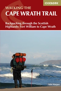
Walking the Cape Wrath Trail
Backpacking through the Scottish Highlands: Fort William to Cape Wrath
£17.95
A guidebook to the Cape Wrath Trail, a long-distance trek through the Scottish Highlands from Fort William to Cape Wrath. The Cape Wrath Trail is a 230 mile, 3-week challenge through wild and magnificent landscapes, such as Morar, Knoydart, Torridon and Assynt. Crossing such empty country, it is for the experienced backpacker only.
More information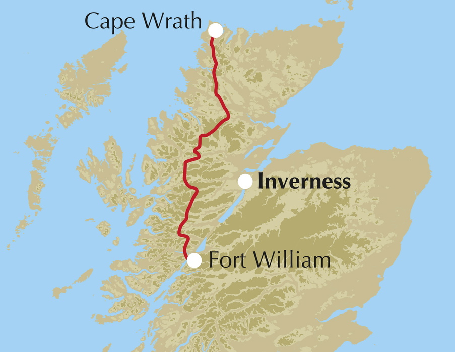
What is the Cape Wrath Trail?
The Cape Wrath Trail is widely regarded as the toughest long-distance backpacking route in Britain. It's a 230-mile (370km) journey through some of the most remote and spectacular landscapes in the Scottish Highlands, from Fort William in the south to the lighthouse at Cape Wrath on the far north-west coast.
Unlike Scotland's other great long-distance routes, the Cape Wrath Trail is not an officially recognised National Trail. It has no waymarking, no fixed route and no pack-carrying services. It is, as guidebook author Iain Harper puts it, "a jigsaw of routes to be assembled according to your preferences." That freedom and the self-reliance it demands are precisely what draw experienced backpackers to it. Cameron McNeish, who has walked and written extensively about the trail, has described it as "the sort of long-distance route that most keen walkers dream of" and "the hardest long-distance backpacking route in the UK."
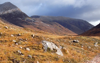
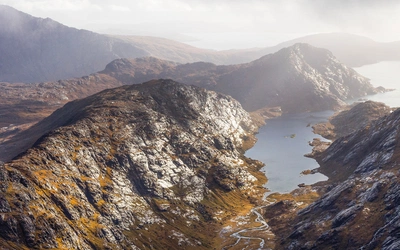
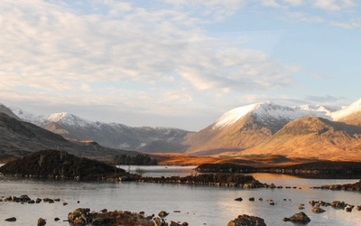
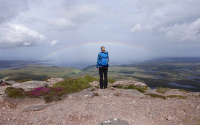
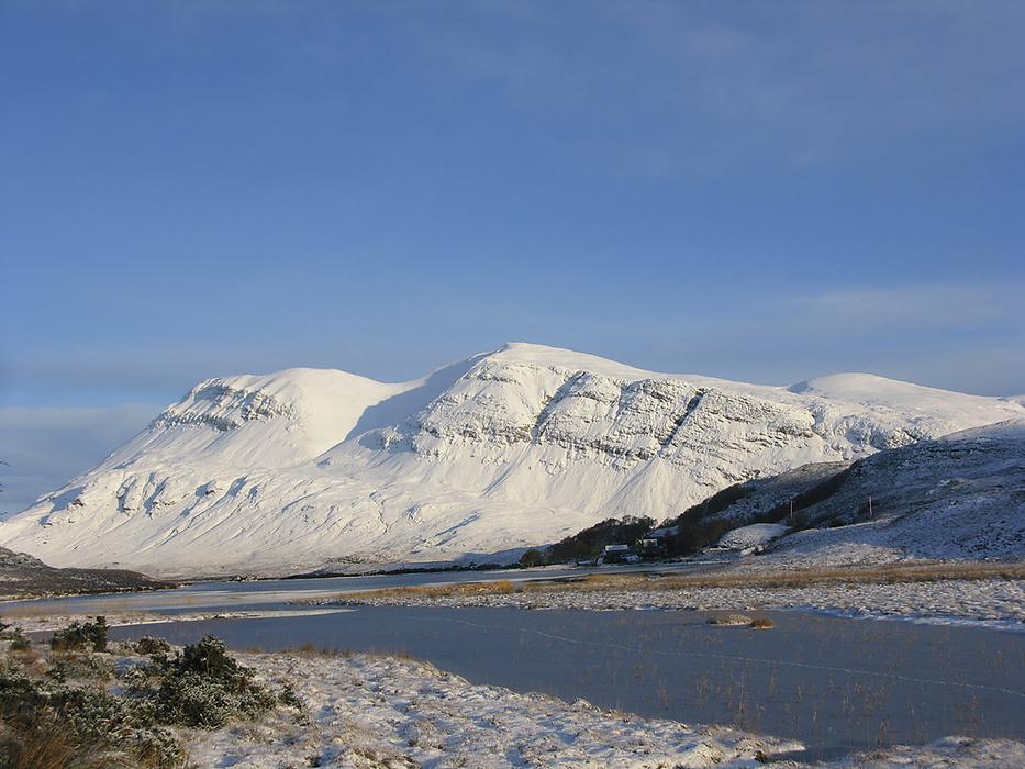
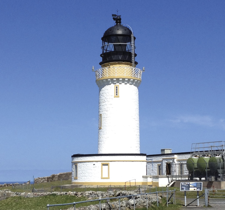
The trail passes through an extraordinary succession of wild landscapes: the rough bounds of Knoydart, the dramatic ridges of Torridon, the internationally acclaimed geology of Assynt, the shadow of Arkle and Foinaven, and finally the golden strand of Sandwood Bay before the lighthouse comes into view. At the finish, you are closer to the Faroe Islands than to England.
This planning guide answers the most common questions walkers have before setting out. For complete stage-by-stage route descriptions, accommodation listings, OS mapping and elevation profiles, see the Cicerone Cape Wrath Trail guidebook.
How long is the Cape Wrath Trail?
The Cape Wrath Trail covers approximately 230 miles (370km), making it one of the longest and most demanding long-distance routes in the British Isles. The route is divided into three main sections and 14 stages, running south to north from Fort William to Cape Wrath.
| Section | Distance | Duration |
|---|---|---|
| Fort William to Strathcarron | 147.4km | 7–9 days |
| Strathcarron to Inverlael (near Ullapool) | 80km | 3–4 days |
| Inverlael to Cape Wrath | 142km | 6–9 days |
| Total | 370km | 16–22 days |
Who is the Cape Wrath Trail suitable for?
The Cape Wrath Trail is not suitable for beginners or casual walkers. It is intended for experienced backpackers who are confident navigating with a map and compass in remote, often pathless terrain, comfortable crossing rivers without bridges, and capable of carrying multiple days of supplies between resupply points.
Signage along the trail is, at points, non-existent. There are stretches where you may be a full day's walk from the nearest road. River crossings — which can become genuinely dangerous after heavy rain — are a recurring feature. The guidebook itself warns walkers they are entering "remote, sparsely populated, potentially dangerous mountain country."
That said, the trail is not a technical mountaineering route. It is within the ability of most ambitious and experienced hill walkers who prepare thoroughly, carry appropriate equipment and are willing to adapt their plans to conditions.
What are the stages of the Cape Wrath Trail?
The trail is described in 14 stages, but these are not intended as fixed daily itineraries. Varying fitness, terrain and weather make it impossible to prescribe generic mountain days. Some stages can be completed comfortably in a day; others may require two or three. Walkers are encouraged to build their own itinerary around their pace and experience.
Three alternative stages are also available for Section 1 (via the Great Glen Way through Laggan and Cluanie rather than Knoydart), offering a different and slightly more accessible approach to Morvich. A further alternative exists for Stage 6 (via Bendronaig to Kinlochewe) and Stage 9 (Ullapool variant), and Stage 11 (Loch Ailsh to Glendhu).
| Stage | Distance | Duration |
|---|---|---|
| Section 1: Fort William to Strathcarron | ||
| Fort William to Glenfinnan | 34.3km (21¼ miles) | 1–2 days |
| Glenfinnan to Glen Dessarry | 18.1km (11¼ miles) | 1 day |
| Glen Dessarry to Barisdale | 24.8km (15½ miles) | 1–2 days |
| Barisdale to Morvich (near Shiel Bridge) | 31.5km (19½ miles) | 2 days |
| Morvich (near Shiel Bridge) to Strathcarron | 38.7km (24 miles) | 2 days |
| Section 2: Strathcarron to Inverlael | ||
| Strathcarron to Kinlochewe | 34.7km (21½ miles) | 1–2 days |
| Kinlochewe to Strath na Sealga | 27.3km (17 miles) | 1 day |
| Strath na Sealga to Inverlael (near Ullapool) | 18.2km (11¼ miles) | 1 day |
| Section 3: Inverlael to Cape Wrath | ||
| Inverlael to Oykel Bridge | 33.5km (20¾ miles) | 1–2 days |
| Oykel Bridge to Inchnadamph | 29.9km (18½ miles) | 1–2 days |
| Inchnadamph to Glendhu | 19.3km (12 miles) | 1 day |
| Glendhu to Rhiconich | 30.6km (19 miles) | 1–2 days |
| Rhiconich to Sandwood Bay | 16.2km (10 miles) | 1 day |
| Sandwood Bay to Cape Wrath | 12.9km (8 miles) | 1 day |
Which direction should I walk the Cape Wrath Trail?
The trail is almost always walked south to north — Fort William to Cape Wrath — and this is the direction described in the guidebook. Walking this way builds towards an exceptional finale: the approach to Cape Wrath via Sandwood Bay, with the lighthouse appearing on the horizon as you cross the headland, is one of the great moments in British long-distance walking. The trail can be walked north to south, but you lose that crescendo, and the guidebook's route descriptions will need to be read in reverse.
How difficult is the Cape Wrath Trail?
The Cape Wrath Trail is widely considered the hardest long-distance backpacking route in Britain. It is in an entirely different category from other Highland trails such as the West Highland Way, where civilisation is rarely far away.
Key challenges include:
- No waymarking — navigation is entirely your responsibility throughout
- Trackless terrain — sections involve walking on pathless ground, bog and rough moorland
- River crossings — a frequent and potentially serious hazard, particularly after rain. A small burn crossable in dry weather can become a dangerous torrent after sustained rainfall
- Resupply gaps — limited shops mean carrying several days of food at a time; main resupply points include Kinlochewe, Ullapool and Rhiconich
- Remote country — at points you may be a day or more from the nearest road, let alone help
- No pack-carrying services — you carry everything yourself for the full distance
Experienced backpackers who prepare carefully and build flexibility into their itinerary will find it an immensely rewarding challenge. Those who underestimate it have been known to abandon the trail in the first few days.
When is the best time to walk the Cape Wrath Trail?
May to September is the recommended walking season, with April and early October possible for experienced walkers who are prepared for colder, less predictable conditions.
Within that window:
- April, May and June are often ideal: long days, fewer midges, and better chances of settled weather, though snow may linger on higher ground early in the season
- July and August offer the longest days but bring midges in full force and may see limited accommodation booked up at popular stops
- September and October are good alternatives — midges diminish, the light is exceptional, but deer stalking is active on many estates and military operations at Cape Wrath itself may restrict access
Walking outside the main season is possible but requires specialist mountain equipment (potentially including crampons and ice axe), and daylight is limited to around six hours in midwinter, making daily distances of 20km a practical maximum.
One important timing consideration: Cape Wrath itself is within a Ministry of Defence live firing range. Access can be restricted without notice. Always check range activity in advance by calling range control on 01971 511242 (8am–5pm). There is no mobile reception at the cape, so all arrangements must be made before you arrive.
What about midges?
Midges are a serious and unavoidable consideration on the Cape Wrath Trail as the route passes through the heart of midge country. The western Highlands, with their abundant rainfall and sheltered glens, are among the worst-affected areas in Scotland.
The midge season runs roughly from late May to early October, with July and August at their worst. DEET-based repellents are the most effective defence, though they should be kept away from Gore-Tex and other sensitive fabrics. A midge head net is worth carrying. The one natural defence is wind — midges cannot fly in even a gentle breeze, and the exposed sections of the trail often provide some relief. Lochside campsites, particularly around Knoydart and the western glens, can be severe in still, overcast conditions.
What accommodation is available?
Accommodation on the Cape Wrath Trail is sparse and must be planned carefully. Unlike the West Highland Way, where hotels, B&Bs and bunkhouses appear at regular intervals, the CWT passes through some of the emptiest country in Britain. In many sections, accommodation options are very limited or non-existent.
Wild camping is both permitted and, for most walkers, essential. Under the Land Reform (Scotland) Act 2003 and the Scottish Outdoor Access Code, wild camping is a legal right across Scotland, subject to the code's principles of responsibility and minimal impact. Given the remoteness of some stages, carrying a tent is a matter of mountain safety, not just preference — bothies can be full, and being without shelter in poor weather in this part of Scotland is genuinely dangerous.
Bothies are an important part of the trail's character and logistics. Several are on or close to the route, offering basic but welcome shelter. The Mountain Bothy Association maintains many of them; a full membership (around £25 per year) supports their upkeep and provides bothy location information. Bothy use comes with responsibilities: leave the space clean, take all non-burnable rubbish with you, and bury human waste well away from the building and any water source.
Hostels, bunkhouses and hotels exist at key points including Fort William, Kinlochewe, Ullapool, Rhiconich and Kinlochbervie, and should be booked well in advance, especially in summer. Many remote establishments close between October and March.
The Cicerone guidebook includes a full accommodation appendix and recommends using Google Maps for up-to-date listings, as accommodation in this part of the world changes more frequently than any printed guide can track.
Do I need a map and compass?
Yes. The Cape Wrath Trail has no waymarking at any point. A map and compass are not optional extras; they are essential safety equipment. You should be a competent navigator, confident in taking and walking on bearings and orientating yourself in low visibility on featureless terrain.
A GPS device or smartphone app with downloaded GPX files is a useful supplement but should never be your primary method of navigation. No electronic device can be completely relied upon in the wet, remote conditions of the northwest Highlands.
The Cicerone guidebook is supported by 1:50,000 OS mapping, and a full list of the OS and Harvey maps covering the route is provided in Appendix E. Harvey also produce a dedicated set of Cape Wrath Trail maps which are waterproof, lightweight and cover the route specifically — an excellent option for keeping pack weight down.
How do I get to the start and back from the finish?
Getting to Fort William: Fort William is served by the scenic West Highland Line from Glasgow Queen Street — a journey of around three hours that is itself one of the great train rides in Britain, crossing Rannoch Moor before arriving at the southern gateway of the Highlands. The Caledonian Sleeper runs nightly from London. Coach services also connect Fort William to Glasgow, Edinburgh and Inverness.
Getting back from Cape Wrath: This requires some planning. A passenger ferry and minibus service connects the Cape Wrath lighthouse to Keodale (near Durness) from May to September, weather, tides and military operations permitting. The ferry is operated by John Morrison (01971 511246) and the minibus by James Mather (07742 670196). From Durness, a bus service runs to Lairg, where you can join trains to Inverness. Always check all services in advance — there is no mobile reception at the cape and the ferry does not run outside the main season.
Outside the ferry season, walkers must return to Kinlochbervie on foot or by arrangement.
What are the river crossings like?
River crossings are one of the most significant hazards on the Cape Wrath Trail and demand serious consideration during planning. In dry conditions, most mountain streams and rivers in the northwest Highlands are wide, shallow and manageable. After sustained rain, the same crossing can become a dangerous torrent with little warning.
The route has been designed to avoid crossings known to be dangerous in very wet conditions, and potentially tricky crossings are noted in the guidebook. However, all river crossings should be treated with caution in wet weather. If you are unsure about a crossing, a detour upstream will often reveal a safer crossing point or an unmarked bridge. If in doubt, do not cross — rivers in Scotland subside quickly when rain stops.
Walking poles are highly recommended for stability during crossings. Some walkers carry lightweight sandals to keep boots and socks dry; others find that Gore-Tex socks with good gaiters offer a more practical solution given the sheer volume of water encountered across the whole route.
What are the route highlights?
The Cape Wrath Trail moves through some of the most dramatic and remote landscapes in the British Isles. Key highlights include:
- Knoydart — accessible only by sea or on foot, the rough bounds of Knoydart are among the most remote and beautiful areas in Scotland. The crossing via Glen Dessarry and Barisdale (Stages 2–3) is one of the finest sections of any long-distance route in Britain
- The Forcan Ridge — a dramatic ridge approach on Stage 4, with exposure and scrambling that give a mountain flavour rarely found on long-distance paths
- Torridon and Beinn Eighe — Stage 6 passes through the ancient sandstone landscape of Torridon, with Beinn Eighe's quartzite summit ridges visible across the glen
- An Teallach and Shenavall — Stage 8 brings you beneath the spectacular buttresses of An Teallach, with the remote Shenavall bothy offering a memorable overnight stop
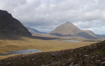
- Assynt — described as an internationally acclaimed geological showpiece, the landscape around Inchnadamph and Glencoul (Stages 10–11) is unlike anywhere else in Britain
- Arkle and Foinaven — the final Highland stages pass beneath these distinctive quartzite mountains, whose white summits are visible for miles
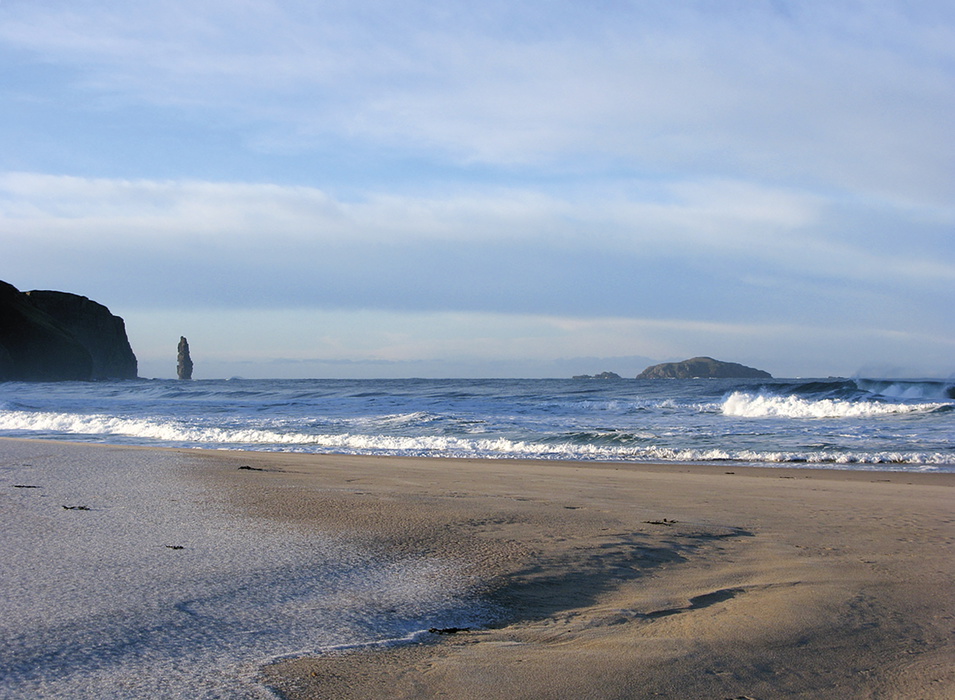
- Sandwood Bay — the vast, dune-backed beach on Stage 13 is one of the most remote and beautiful beaches in Scotland, and the last major landmark before Cape Wrath
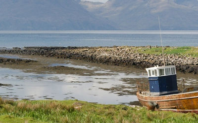
- Cape Wrath lighthouse — the end of the journey, on a clifftop staring out into the North Atlantic, closer to the Faroe Islands than to England
Plan your walk with the Cicerone guidebook
The Cicerone Cape Wrath Trail guidebook, written by Iain Harper and now in its fourth edition (reprinted June 2024), provides everything you need to tackle the route with confidence:
- Detailed stage-by-stage route descriptions for all 14 stages and alternative stages
- Suggested itineraries of 16 to 22 days
- 1:50,000 OS mapping with elevation profiles for each stage
- Accommodation appendix covering bothies, hostels, B&Bs and wild camping options
- Resupply guide (shops, cafés and Post Offices along the route)
- Full transport guide for access points at Fort William, Strathcarron, Kinlochewe, Ullapool and Cape Wrath
- Safety guidance including river crossings, emergency procedures and the CHALET mnemonic
- Equipment checklist tailored to multi-week Highland backpacking
- Useful websites and further reading
Available as a printed guidebook (£17.95) or digital eBook (£17.95).
Walking the Cape Wrath Trail
Backpacking through the Scottish Highlands: Fort William to Cape Wrath
£17.95
A guidebook to the Cape Wrath Trail, a long-distance trek through the Scottish Highlands from Fort William to Cape Wrath. The Cape Wrath Trail is a 230 mile, 3-week challenge through wild and magnificent landscapes, such as Morar, Knoydart, Torridon and Assynt. Crossing such empty country, it is for the experienced backpacker only.
More informationWhat Iain Harper learned walking it in December — and what it taught him about the trail
Iain Harper first attempted the Cape Wrath Trail in 2008, setting out in December (the only time he could manage) before being beaten back by conditions. That experience, and the subsequent research and walking that produced four editions of the Cicerone guidebook, shaped his understanding of what the trail demands and what it gives back.
The trail's appeal, in his view, lies precisely in its lack of formal structure. There is no definitive route, no waymarking, no prescribed itinerary. The jigsaw of paths, drove roads and open hillside that constitute the Cape Wrath Trail invites walkers to assemble their own journey, to take detours, plan alternatives and make the route their own. "Follow as much or as little of the route as you like," he writes. "It's one that will live with you for the rest of your life."
That freedom has its price. Unlike the West Highland Way, where civilisation is never far away, the Cape Wrath Trail offers long stretches of genuine isolation. Dark, boggy moments are part of the experience, but they are, as Harper notes, quickly forgotten amid a solitude and beauty rarely found in modern life.
About Iain Harper, guidebook author:
Iain Harper first set out to walk the Cape Wrath Trail in 2008. As the only time of the year he could do it was December, he gamely set off, only to be beaten back by a severe winter storm. A year later he gave it another shot and finally reached the cape on Christmas Day. Since then he has walked it many times. Having amassed a great deal of research and information he approached Cicerone to completely update and re-write the venerable North to the Cape. Iain has walked extensively in the Scottish Highlands for 20 years but lives and works in the Cotswolds. When not walking he can be found running ultra marathons (he completed the West Highland Way Race in 2011). He is married to Kay.