The West Highland Way: a complete planning guide
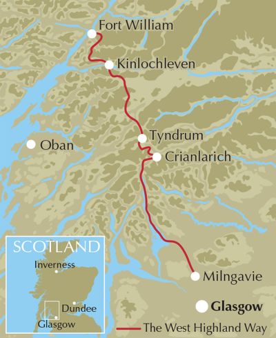
The West Highland Way is a 96-mile (153km) long-distance walking route in Scotland, running from Milngavie near Glasgow to Fort William. It is typically completed in 6–9 days and is suitable for most walkers with a reasonable level of fitness. (Last updated: March 2026 · Guidebook edition: 5th edition, September 2025)
West Highland Way Quick Facts:
- Distance: 96 miles / 153km
- Duration: 6–9 days (7-8 days recommended)
- Start:Milngavie (near Glasgow)
- Finish: Fort William
- Stages: 7
- Difficulty: Moderate
- Designation: Scotland's Great Trails
- Terrain: Forest tracks, lochside paths, open moorland, mountain passes
- Best season: May–October
- Navigation: Well waymarked throughout
- Guidebook: The West Highland Way by Terry Marsh, updated 2025

The West Highland Way
Scottish Great Trail - Milngavie (Glasgow) to Fort William
£17.95
Guidebook to walking the West Highland Way National Trail, a 96 mile Scottish Great Trail route from Milngavie near Glasgow to Fort William, passing Loch Lomond and crossing Rannoch Moor. Suggested itineraries over 6 to 9 days. Includes accommodation guide and pull-out 1:25K OS map booklet.
More informationWhat is the West Highland Way?
The West Highland Way is Scotland's most iconic long-distance walking trail — 96 miles (156km) of ever-changing Highland landscape running from the lowland town of Milngavie, on the outskirts of Glasgow, north to Fort William at the foot of Ben Nevis. It was the first of Scotland's Great Trails and remains the benchmark against which all other Scottish long-distance routes are measured.
The route passes through six distinct mountain ranges without ever demanding technical mountaineering skills. It follows ancient drove roads and military tracks, hugs the eastern shore of Loch Lomond, crosses the wild expanse of Rannoch Moor and winds through the grandeur of Glencoe before the final push into Fort William. As guidebook author Terry Marsh noted after rewalking the route in 2024, one of the things that stands out most is the remarkable sense of camaraderie among walkers — over the course of a week on the trail, you keep meeting the same people and sharing experiences in a way that few walks can replicate.
This planning guide answers the most common questions walkers have before setting out. For complete stage-by-stage route descriptions, accommodation listings, GPX downloads and 1:25k OS mapping, see the Cicerone West Highland Way guidebook.
How long is the West Highland Way?
The West Highland Way covers 96 miles (156km), making it a substantial multi-day undertaking. The route runs south to north in seven stages, from Milngavie near Glasgow to Fort William at the base of Ben Nevis. The terrain varies considerably — early stages are relatively gentle, while the northern half, particularly the section from Kingshouse through to Fort William, is more demanding and more rewarding.
Who is the West Highland Way suitable for?
The route is ideal for first-time long-distance walkers, experienced hikers looking for a classic route and walkers wanting good infrastructure and accommodation.

Where does the route start and finish?
The route starts in Milngavie, a suburban town on the northern edge of Glasgow. It finishes at Fort William, a Highland hub beneath Ben Nevis. Both ends are well connected by public transport: Milngavie has a regular rail service from Glasgow city centre, and Fort William is served by the scenic West Highland Line. This makes the route one of the UK's most accessible long-distance trails as no car is required at either end.
Several intermediate points also have good public transport links. Balmaha, Crianlarich and Bridge of Orchy all offer options to join, leave or break the route mid-journey by train or bus.
How long does it take to walk the West Highland Way?
Most walkers complete the West Highland Way in seven or eight days, which offers a comfortable pace with time to enjoy the landscape. Six days is possible but demanding, leaving no room for rest days or detours. Nine days is the relaxed option — splitting the long Drymen-to-Rowardennan section at Balmaha, for example, allows time to visit the island of Inchcailloch.
The right duration depends on your fitness, experience and how much you want to stop and explore along the way. As the guidebook puts it: your walk should become what you want it to be— not a forced march.
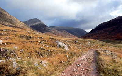
How much ascent is involved? What is the terrain like?
The West Highland Way involves around 4,800 metres (15,700 feet) of total ascent over its 96 miles, though this is spread across the whole route rather than concentrated in a few big climbs. The terrain is varied — from well-maintained tracks and old military roads in the south, to rougher, boggier ground on Rannoch Moor and the higher sections further north. The most demanding single ascent is the Devil's Staircase between Kingshouse and Kinlochleven, though even this is manageable for walkers of reasonable fitness. Good waterproof boots with ankle support are essential throughout.
What are the stages of the West Highland Way?
NB Stage 3 (Rowardennan to Crianlarich) is the longest and most demanding day. Many walkers choose to break it by stopping at Inversnaid or Inverarnan — a worthwhile option for those wanting a more relaxed pace.
| Stage | Start/Finish | Distance (miles) | Time (hr) |
|---|---|---|---|
| 1 | Milngavie/Drymen | 12 | 5½–6 |
| 2 | Drymen/Rowardennan | 14¾ | 6–7 |
| 3 | Rowardennan/Crianlarich | 20 | 10–12 |
| 4 | Crianlarich/Bridge of Orchy | 13½ | 7 |
| 5 | Bridge of Orchy/Kingshouse | 12 | 5–6 |
| 6 | Kingshouse/Kinlochleven | 9 | 4-5 |
| 7 | Kinlochleven/Fort William | 15½ | 7–8 |

Which direction should I walk the West Highland Way?
The vast majority of walkers go south to north — Milngavie to Fort William — and this is the recommended direction. Walking this way means you have the prevailing wind and weather largely at your back, and you finish with the most dramatic scenery: the approach to Fort William via the Lairig Mòr, with Ben Nevis coming into view, provides a fitting finale. Walking north to south is possible and perfectly legal, but waymarking is less intuitive in that direction and you'll be walking against the flow of most other walkers.
How difficult is the West Highland Way?
The West Highland Way is generally considered moderate in difficulty.
- The terrain is varied but mostly non-technical.
- Some sections are long and physically demanding.
- The route includes sustained ascents, particularly in the Highlands.
- Weather conditions can add to the challenge.
The path is suitable for walkers with a reasonable level of fitness, including those attempting their first long-distance trail, provided they prepare adequately. Also, because the route is based on many old drove roads and military tracks, it is never that far from help – the only real sense of isolation comes with the crossing of Rannoch Moor.
When is the best time to walk the West Highland Way?
May to October is the recommended walking season. Daylight hours are longer, facilities along
the route are more likely to be open, and the weather — while never guaranteed in Scotland — is generally more settled.
Within that window, May–June and September–October are particularly good choices, as they avoid the worst of the midges — the notorious biting insects that can make summer evenings uncomfortable. Suitably experienced backpackers can walk the route at any time of year, including winter, though conditions become significantly more challenging.
A few practical timing notes worth bearing in mind:
Early May: Motorbike trials events affect parts of the route — check before you go.
Mid-August to mid-October: Deer stalking takes place on and near the route, though this should have minimal impact on walkers.
Accommodation: Book as far in advance as possible, especially for summer. Popular overnight stops can fill months ahead, and your itinerary may need to be built around what's available.

What accommodation is available?
The West Highland Way has a good range of accommodation options at all price points, from campsites and bothies to hostels, bunkhouses, B&Bs, guesthouses and hotels. Most walkers stay in the villages and towns along the route, with key overnight stops including:
Drymen (end of Stage 1)
Rowardennan (end of Stage 2)
Crianlarich (end of Stage 3, with supplies available)
Tyndrum (supplies available, alternative overnight stop)
Bridge of Orchy (end of Stage 4)
Kingshouse (end of Stage 5)
Kinlochleven (end of Stage 6)
Fort William (end of Stage 7)
Pack-carrying services are a popular option for those who prefer not to carry a heavy pack. Independent operators will transfer your luggage between your overnight stops, so you walk each day with just what you need. The Cicerone guidebook includes a comprehensive accommodation table and details of pack-carrying services.
Is wild camping allowed on the West Highland Way?
Yes. Wild camping is permitted on the West Highland Way under the Scottish Outdoor Access Code. The code asks that it be lightweight, done in small numbers, and for no more than two or three nights in any one place.
Practical guidance: avoid camping in enclosed crop fields or near farm animals; keep well away from buildings, roads, or historic structures; and, if you wish to camp close to a property, ask the owner. Take away all litter, remove all traces of your pitch and any open fire, and use a stover rather than an open fire wherever possible.
Note that bylaw restrictions apply to camping on the eastern shores of Loch Lomond during certain months — check the current position before planning an overnight stop in that section.
Is the West Highland Way well waymarked? Do I need a map?
The route is waymarked throughout with a distinctive thistle symbol, and most walkers find it straightforward to follow in good visibility. That said, a map and compass — or a GPS device — are still strongly recommended. In poor weather, particularly on the open expanse of Rannoch Moor, navigation can become genuinely challenging. Carrying a 1:25,000 OS map (such as the pull-out map booklet included with the Cicerone guidebook) means you're prepared for any conditions and can explore side routes with confidence.
What about midges?
Midges are a serious planning consideration for any walking trip in Scotland. The midge is at its worst from late May through to September, particularly in still, overcast conditions — and the areas around Loch Lomond and the wetter western sections of the route can be especially bad. To manage them: carry a good midge repellent, consider a midge head net, and try to plan exposed campsites or breezy spots where possible. July and August are peak midge months; early May or October offer far fewer, though the weather is less predictable.

How do I get to the start — and back from the finish?
Getting to Milngavie: Milngavie is a short train ride from Glasgow city centre. Trains run frequently and take around 25 minutes. Glasgow itself is well connected to the rest of the UK by rail, coach and air.
Getting back from Fort William: Fort William is served by the scenic West Highland Line, one of the great railway journeys in Britain. Direct trains run to Glasgow Queen Street, with connections onward across the UK. Coach services also link Fort William to Glasgow and Inverness.
Transport along the route: Several points on the Way have public transport links, making it possible to walk the route in stages over multiple visits. Balmaha, Crianlarich, Tyndrum, and Bridge of Orchy all have bus or train connections. The Cicerone guidebook includes a full transport guide covering all access points.
Can I walk the West Highland Way with a dog?
Yes, dogs are welcome on the West Highland Way. They must be kept on a lead, particularly when near livestock, which you will encounter on several stages. Plan accommodation in advance with dogs in mind, as not all B&Bs and hostels accept pets. Some sections of the trail can be more challenging for dogs, particularly on rougher terrain.
What are the route highlights?
The West Highland Way moves through dramatically different landscapes as it travels north. Key highlights include:
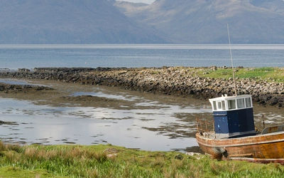
Loch Lomond — the route follows the eastern shore of Scotland's most famous loch for much of Stages 2 and 3. The section along the lochside through ancient oak woodland is one of the most beautiful stretches of any long-distance path in Britain.
Conic Hill — a relatively modest climb at the end of Stage 2, but the view from the summit overLoch Lomond and its islands is one of the great moments of the walk.
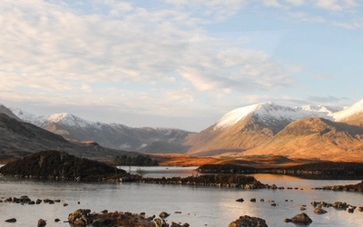
Rannoch Moor — one of the largest and wildest expanses of open moorland in Europe. The crossing during Stage 5 offers a rare sense of genuine remoteness.
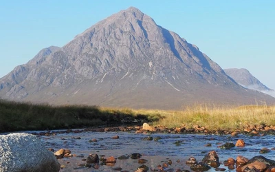
Glencoe and Buachaille Etive Mòr — the approach into Glencoe, with the iconic pyramid of Buachaille Etive Mòr dominating the skyline, is the most dramatic moment of the whole route.
The Devil's Staircase — the highest point on the trail, reached on Stage 6. The climb out of Glencoe offers panoramic views over the surrounding mountains before the descent into Kinlochleven.
The Lairig Mòr — the quiet, hidden valley leading into the final stage, offering a peaceful contrast to the drama of what has come before Fort William.
Is there more to explore beyond the main route?
For walkers who want to take the adventure further, there are mountain detours and side loops available for almost every stage of the West Highland Way. Options include climbing Ben Lomond, ascending Beinn Dorain above Bridge of Orchy, crossing the Black Mount from Inveroran to Glencoe, and exploring Glen Nevis or the Mamores near Fort William.
These alternatives are covered in the Cicerone guide Not the West Highland Way: A Mountain High Way, which includes 14 route variants and side loops, with options to summit nearby Munros. It ranges from gentle two-day backpacking trips for less experienced walkers to challenging multi-day mountain routes.
For those who complete the West Highland Way and want to keep going, the Great Glen Way begins at Fort William and continues north to Inverness — a natural extension for walkers who want to traverse Scotland end to end.
"What really stood out was the tremendous sense of camaraderie that developed among walkers travelling on the same day. Over a period of a week, while you’re not travelling in one another’s pockets, you do keep meeting the same people and share experiences."
— - Terry Marsh, guidebook author
Plan your walk with the Cicerone guidebook (updated 2025)
The Cicerone West Highland Way guidebook, written by Dr Terry Marsh and now in its fifth edition (reprinted September 2025), provides everything you need to walk the route with confidence:
Detailed stage-by-stage route descriptions for all 7 stages
Suggested itineraries from 6 to 9 days
Full accommodation guide including all key overnight stops
Pull-out 1:25K OS map booklet
Downloadable GPX files for use on GPS devices and smartphone apps
Transport information for all access points along the route
Practical advice on what to pack, pack-carrying services, cash management, weather, and emergencies
Background on the history, geology, wildlife and culture of the Highlands
Available as a printed guidebook (£17.95) or digital eBook, with free UK delivery and free route updates online.
The West Highland Way
Scottish Great Trail - Milngavie (Glasgow) to Fort William
£17.95
Guidebook to walking the West Highland Way National Trail, a 96 mile Scottish Great Trail route from Milngavie near Glasgow to Fort William, passing Loch Lomond and crossing Rannoch Moor. Suggested itineraries over 6 to 9 days. Includes accommodation guide and pull-out 1:25K OS map booklet.
More information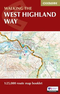
West Highland Way Map Booklet
1:25,000 OS Route Mapping
£9.95
This compact booklet of maps shows the full route of the 95 mile West Highland Way, one of Scotland’s Great Trails. This booklet is included with the Cicerone guidebook to the trail and shows the full route on OS 1:25K maps. The map booklet can be used to walk the trail in either direction.
More informationWhat our guidebook author learned walking it four times
Dr Terry Marsh has walked the West Highland Way in its entirety four times across three decades — first in October 1995, then returning the following May to finish what an unexpected DST clock change had cut short, again in 2002, and most recently in 2024 for this fifth edition.
Walking the route across two seasons on that first attempt turned out to be an advantage. The October conditions offered ideal temperatures for backpacking and exceptional light for photography. The May return brought snowmelt rivers, clearer mountain paths and an entirely different character to the landscape. If you're choosing between early and late season, both have a genuine case.
The 2002 revision brought something Terry hadn't anticipated: the camaraderie. Walking the route in its entirety over a week, he noticed that you keep meeting the same faces — at overnight stops, on the path, sheltering from the same squall. You're not travelling together, but you're travelling alongside each other, and that changes the experience. It's one of the things that makes the West Highland Way feel different from a solo mountain walk, and it's worth knowing before you go.
After four complete walks and nearly thirty years of revisions, his advice is simple: plan your daily distances around what you can comfortably manage, not what the stages suggest. The stages are a framework, not a prescription. Use a taxi if you need to shunt yourself forward. Modify your plans. The walk should become what you want it to be.
More Information:
The West Highland Way Association
Our guidebook is available as an eBook too.
About Terry Marsh, guidebook author:
Lancashire-born writer and photographer Dr Terry Marsh specialises in the outdoors and travel. He has been writing guidebooks since the mid 1980s and is the author or revision author/editor of over 100 titles, including the award-winning Cicerone guides to the Coast-to-Coast Path (first published in 1993), The Shropshire Way (1999) and Great Mountain Days in the Pennines (2013). Terry has a long-standing interest in the Scottish islands, Cumbria and the Lake District and the Yorkshire Dales. Academically, he is an historical geographer holding a Master of Arts degree with Distinction in Lake District Studies and a PhD in Historical Geography. He is a Life Member of the Outdoor Writers and Photographers Guild.