Walking in Catalunya – Girona Pyrenees: a complete planning guide
Leave behind Girona's medieval walls, narrow cobbled streets and riverside lined with colourful houses, and you will find a network of trails twisting among volcanic cones, rocky gorges with spectacular waterfalls and long-forgotten ruins on the lush mountains of the Alta Garrotxa. Stretching north from the Pre-Pyrenees into the high peaks of the Girona Pyrenees, this corner of Catalunya offers a remarkable variety of walking across three distinct areas: Garrotxa, Ripollès and the Cadí-Moixeró Natural Park. With 35 graded day walks ranging from 5km to 19km and taking between 2 and 8 hours, it is one of Spain's most rewarding and least-discovered walking destinations. (Last updated: June 2026 · Guidebook edition: 1st edition, October 2023)
Walking in Catalunya - Girona Pyrenees, quick facts:
- Location: Girona province, Catalunya, northern Spain
- Total routes: 35 graded day walks
- Distance range: 5km to 19km per walk
- Typical duration: 2 to 8 hours per walk
- Difficulty: Grade 1 (easy) to Grade 3+ (difficult terrain with easy scrambling)
- Terrain: Volcanic zone, forested gorges, river valleys, alpine meadows, rocky Pyrenean ridges
- Highest point: Puigmal, 2913m (Walk 24)
- Navigation: Itinerànnia waymarked network, GR long-distance trails, and PR-C routes; 1:25,000 or 1:50,000 maps included for every walk; GPX files available for all 35 routes
- Best season: April to November for most routes; lower Garrotxa walks accessible year-round
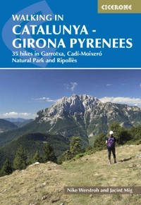
- Guidebook:Walking in Catalunya – Girona Pyrenees by Nike Werstroh and Jacint Mig, 1st edition (Cicerone, 2023)
Walking in Catalunya - Girona Pyrenees
35 hikes in Garrotxa, Cadí-Moixeró Natural Park and Ripollès
£17.95
SALE
£15.26
35 varied day walks among the rocky mountains, forested slopes and idyllic wine country in and around Girona. Routes range from 5 to 19km and cover Garrotxa, Ripollès and the Cadí-Moixeró Natural Park.
More information
What is Walking in Catalunya – Girona Pyrenees?
Walking in Catalunya – Girona Pyrenees is a Cicerone guidebook by Nike Werstroh and Jacint Mig describing 35 graded day walks in the Girona province of northeastern Spain. The walks are divided across three areas: the volcanic Garrotxa (13 walks), the mountain region of Ripollès (14 walks), and the Cadí-Moixeró Natural Park (8 walks). Routes range from gentle valley strolls and forested gorge walks to demanding summit routes above 2500m on peaks such as Puigmal, Pedraforca, and the Pic de la Dona.
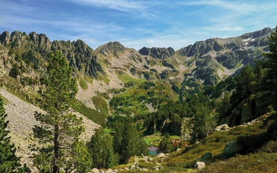
The landscape across these three areas is genuinely diverse. In the Garrotxa, a monogenetic volcanic field shaped by around 40 volcanoes, oak and beech forests cover the lower slopes, and the waterfalls and gorges of the Alta Garrotxa provide some of the most dramatic walking in the province. To the north, the Ripollès opens into broad mountain valleys, high ridges on the Franco-Spanish border, and the magical rack railway valley of Núria. Further west, the Serra de Cadí and Serra de Moixeró rise into a limestone and schist landscape of long ridges and sweeping views, dominated by the iconic double peak of Pedraforca, one of the most photographed mountains in all of Catalunya.
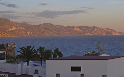
For walkers more familiar with the Pyrenees from the French or Aragonese side, the Girona Pyrenees offer a notably quieter and more varied alternative. The region is easily reached from both Barcelona and Girona airports, making it a practical as well as a spectacular destination.
This planning guide answers the most common questions walkers have before setting out. For complete walk-by-walk route descriptions and mapping, see the Cicerone Walking in Catalunya – Girona Pyrenees guidebook.
The 35 walks at a glance
The guidebook organises its 35 day walks into three geographic sections, reflecting the very different character of each area.
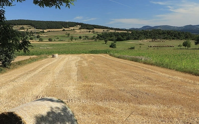
Garrotxa (Walks 1–13) covers the volcanic landscapes of the Natural Park of Garrotxa Volcanic Zone, the deep gorges of the Muga and Alta Garrotxa, and the forested ridges of Puigsacalm and El Mont. Walks range from the easy Volcà de Santa Margarida circuit (5km, 2hr, Grade 1) to the demanding Puigsacalm from Joanates (11km, 6hr–6hr 30min, Grade 3+).
Ripollès (Walks 14–27) stretches from the gentle Camprodon valley and the Roman road of the Via Romana to the high Pyrenean peaks of Puigmal (19km, 8hr, Grade 3) and the Pic de la Dona and Bastiments (12.5km, 5hr 30min–6hr, Grade 3). The Camí Vell de Núria (Walk 23) is the only linear walk in the book, following the historic pilgrimage route into the Núria valley with the option to return by the famous Cremallera rack railway.
Cadí-Moixeró Natural Park (Walks 28–35) offers the book's most iconic summit routes, including the celebrated Pedraforca 360 circuit (17.5km, 5hr 30min, Grade 2) and the exposed Pedraforca Superior (8.5km, 5hr 30min, Grade 3+). The ridgeline walk of Penyes Altes de Moixeró (12.5km, 3hr 30min, Grade 1) provides a gentler but no less spectacular alternative.
| Route | Start/Finish | Distance | Time |
|---|---|---|---|
| Puig de Bassegoda | Collet de la Teia | 13.5km | 5hr 30min–6hr |
| Muga Gorge | Bassegoda Park | 10.5km | 3hr 30min |
| Beuda to El Mont | Beuda | 11km | 4hr 20min |
| Sadernes to Salt de Brull | Sadernes | 17.5km | 5hr 30min–6hr |
| Volcà de Santa Margarida and Croscat | Can Blanc | 12km | 3hr 30min |
| Puig Rodó and Sant Miquel del Corb | Les Preses | 13km | 5hr |
| Salt de la Coromina and Camí Ral | Els Hostalets d'en Bas | 11km | 3hr 30min |
| Puigsacalm from Joanates | Joanates | 11km | 6hr–6hr 30min |
| Puigsacalm from Coll de Bracons | Coll de Bracons | 9km | 3hr |
| Salt de Sallent | Sant Privat d'en Bas | 12km | 4hr 30min |
| Oix to Santa Maria d'Escales | Oix | 12.5km | 4hr |
| Castell de Besora | Montesquiu | 10km | 3hr |
| Gorg de Masica | Vallfogona de Ripollès | 11km | 4hr–4hr 30min |
| Via Romana | Sant Pau de Segúries | 11km | 4hr |
| Camprodon to Sant Antoni | Camprodon | 5km | 2hr |
| Serra Cavallera from Camprodon | Camprodon | 18.5km | 6hr 30min–7hr |
| Camí de Carboneres | Setcases | 11.5km | 4hr 30min |
| Gra de Fajol | Vall de Ter | 12.5km | 5hr 30min–6hr |
| Pic de la Dona and Bastiments | Vallter 2000 | 12km | 4hr 30min–5hr |
| Seven gorges trail | Campdevànol | 9km | 2hr 30min–3hr |
| Taga from Ribes de Freser | Ribes de Freser | 13km | 5hr |
| Queralbs to Font de l'Home Mort | Queralbs | 14.5km | 5hr–5hr 30min |
| Camí Vell de Núria | Queralbs/Núria | 8km | 3hr |
| Puigmal | Núria | 9km | 4hr |
| Pic de Finestrelles | Núria | 12km | 5hr |
| Salt del Grill and Coma de Vaca | Queralbs | 19km | 8hr |
| Falgars and Roc de la Lluna | La Pobla de Lillet | 18km | 5hr 30min |
| La Tosa | Trencapinyes car park | 16km | 6hr |
| Penyes Altes de Moixeró | Gréixer | 17km | 6hr 30min |
| Els Empedrats | Els Empedrats car park | 11.5km | 4hr 30min |
| Via del Nicolau | Guardiola de Berguedà | 12.5km | 3hr 30min |
| Pedraforca Superior | Mirador de Gresolet | 8.5km | 5hr 30min |
| Saldes to Gresolet | Saldes | 13km | 4hr–4hr 30min |
| Comabona | Santuari de Gresolet | 13.5km | 5hr 30min |
| Pedraforca 360 | Gósol | 17.5km | 5hr 30min |
The most demanding walks in the book are concentrated in the Ripollès and Cadí-Moixeró sections. Walk 26 (Salt del Grill and Coma de Vaca) is the longest at 19km with 1530m of ascent and should only be attempted by fit, experienced walkers in settled weather.

Who is this guidebook suitable for? How difficult are the walks?
The 35 walks cover a genuine range of ability levels, and most walkers with reasonable fitness will find several routes well suited to them in each area.
Grade 1 walks (easy, minimal ascent) include the Muga Gorge (Walk 2), Volcà de Santa Margarida and Croscat (Walk 5), Seven gorges trail (Walk 20), and Camprodon to Sant Antoni (Walk 15). These are accessible to most walkers and to those who prefer shorter, lower-level days.
Grade 2 walks form the backbone of the book and suit walkers comfortable with half-day or full-day outings on moderate terrain. Most walks in the Garrotxa fall into this category, as do several of the Ripollès and Cadí-Moixeró routes.
Grade 3 and 3+ walks require a good level of fitness and some experience of mountain walking. Grade 3+ routes (Puigsacalm from Joanates and Pedraforca Superior) involve easy scrambling where hands are needed. These are not technical climbs, but they are not suitable for inexperienced walkers or in poor conditions.
The grading in the guidebook is relative to the other walks in the book, not to a universal scale. Bad weather can make any walk significantly more challenging, and conditions on the higher peaks can change rapidly. Comfortable hiking boots with ankle support, waterproofs, and a warm layer are essential on all mountain routes, even in summer.
Can I walk just a section of the area?
The guidebook lends itself well to a base-centred approach, with each of the three areas offering enough walks for a dedicated stay of several days.
Garrotxa (around Olot) provides 13 walks and is the most accessible area year-round. It suits walkers who prefer a gentler landscape and well-marked trails, and it is an ideal base for those combining walking with visits to Girona city or the Costa Brava.
Ripollès (based from Camprodon, Ribes de Freser, Setcases, or Queralbs) offers 14 walks covering the full range from Grade 1 to Grade 3, including several routes accessible only to those with their own transport. A stay in Ribes de Freser opens up the Núria valley routes by rack railway.
Cadí-Moixeró Natural Park (based from Bagà, Saldes, Gósol, or Guardiola de Berguedà) suits walkers primarily interested in mountain routes and the iconic Pedraforca massif.
Most of the linear walks are described as there-and-back routes due to limited public transport (Walks 2, 9, 13, 14, 21, 24 and 31). Plan return logistics before setting out.
When is the best time to walk in the Girona Pyrenees?
Spring (April to May): The Garrotxa walks are at their best in spring, when wildflowers carpet the volcanic slopes and the air is fresh. Snow lingers on the higher Pyrenean peaks well into May, and some summit routes may still be blocked. Expect some rain, particularly around Olot, which is the wettest part of Catalunya.
Summer (June to August): The main season for all routes. Alpine flowers bloom on the higher meadows from late May, and the Pyrenean peaks are generally clear of snow from June. Temperatures are hot in the valleys but cooler and more comfortable at altitude. Afternoon thunderstorms are common in the mountains and can arrive quickly; plan to be off exposed ridges by early afternoon on unsettled days.
Autumn (September to October): Often the best season for walking. Temperatures ease, crowds thin, and the forests of the Garrotxa turn to golden and russet tones. Mushroom picking has a long tradition in Catalunya and the forests are busy with locals in autumn. Most routes remain fully accessible until late October.
Winter (November to March): High Pyrenean routes are not suitable for most walkers in winter without appropriate equipment and experience. The lower Garrotxa walks, however, are accessible year-round and can provide excellent walking even in the winter months.

What accommodation is available in the Girona Pyrenees?
Accommodation is well spread across all three areas, with options to suit most budgets.
Olot is the best-equipped base for the Garrotxa, with several hotels, restaurants, cafés and shops. Guest houses are also available in the Bas Valley and in villages near Olot, and there are many campsites in the area, including one with bungalows and an astronomical observatory near Albanyà.
Ripollès is served by Ripoll (with a train connection to Ribes de Freser), Camprodon, and Setcases, all of which have hotels, guest houses, and campsites. A hotel and campsite in Núria itself allow walkers to spend several days exploring the high mountain routes. The Cremallera rack railway from Queralbs to Núria makes this one of the more unusual bases in the book.
Cadí-Moixeró Natural Park is served by Bagà, Guardiola de Berguedà, Saldes, and Gósol, each with restaurants and shops. Campsites are plentiful in this area.
Catalunya has a growing rural tourism offer, and the official guide to tourism establishments can be found at http://establimentsturistics.gencat.cat. A full list of campsites is provided in Appendix B of the guidebook.
How do I get to the Girona Pyrenees?
The region is served by two international airports. Girona is the more convenient option for the eastern Garrotxa and Ripollès areas. Barcelona is the main hub, with more frequent flights, and provides easy access to all three areas by road, typically within 1.5 to 2 hours. Both airports are well served by budget airlines from UK and European airports.
Driving is strongly recommended for this region. Many of the trailheads are not served by public transport, and a hire car, picked up at either airport, gives maximum flexibility across all three areas. Several walks are described as there-and-back routes precisely because return transport is not available.
For those travelling without a car, trains run from Barcelona (Estació de Sants) to Girona, Ripoll, and Ribes de Freser. Bus services connect larger towns, but rural frequencies are low. Always check timetables locally, or contact the tourist office in advance. The Cremallera rack railway from Queralbs to Núria (prebooking advisable) is a scenic and practical alternative for the Núria valley walks; see www.valldenuria.cat/en.
Useful journey planning websites: www.renfe.com, www.raileurope.com, www.thetrainline.com.
Is it easy to navigate the walks?
Navigation in the Girona Pyrenees is well supported by a comprehensive waymarking network. Most walks use the Itinerànnia network, an extensive system of waymarked trails across the Garrotxa, Ripollès and Alt Empordà. A frequent horizontal yellow sign on trees and rocks marks the trails, with signposted junctions indicating place names, distances, and directions.
Long-distance GR trails (marked with white above red stripes) and shorter PR-C routes (yellow and white) are also used in several walks. Where waymarking is absent or supplemented by cairns, the route descriptions make this clear.
Each walk is illustrated with either 1:25,000 or 1:50,000 mapping, and GPX files are available to download free at www.cicerone.co.uk/1163/GPX for all 35 routes. For additional mapping, look out for Alpina maps in local bookshops or at www.editorialalpina.com. The interactive planning tool at www.itinerannia.net/en is also worth consulting before setting out.
What are the highlights of the Girona Pyrenees?
The Garrotxa's volcanic landscape is unlike anywhere else in Spain. The Volcà de Santa Margarida and Croscat (Walk 5) circuit is the most popular introduction to the volcanic zone, but the remote Muga Gorge (Walk 2) and the Alta Garrotxa's forest paths to hidden churches and long-forgotten ruins are equally compelling for walkers who prefer solitude.
In the Ripollès, the Camí Vell de Núria (Walk 23) stands out as the book's only linear route, following the ancient pilgrimage path into the sanctuary valley of Núria and returning by the Cremallera rack railway, opened in 1931. The summit of Puigmal (Walk 24), at 2913m the highest point in the book, rewards with panoramic views across the Pyrenees on clear days.
In the Cadí-Moixeró Natural Park, Pedraforca is the undisputed centrepiece. Painted pink in the early morning and orange at dusk, the double-peaked silhouette of this mountain is one of the great photographic icons of Catalunya. The Pedraforca 360 walk (Walk 35, 17.5km) circumnavigates the massif, while the more demanding Pedraforca Superior (Walk 32) tackles the upper crest itself.
About the guidebook and how to buy it
Walking in Catalunya – Girona Pyrenees by Nike Werstroh and Jacint Mig was first published by Cicerone in October 2023. The book covers 35 graded day walks across three areas of the Girona province, with 1:25,000 or 1:50,000 maps for every walk, full route descriptions, and practical appendices covering contacts, campsites, and a Catalan–Spanish–English glossary.
Available as a printed guidebook (£17.95) or digital eBook (£17.95).
Walking in Catalunya - Girona Pyrenees
35 hikes in Garrotxa, Cadí-Moixeró Natural Park and Ripollès
£17.95
SALE
£15.26
35 varied day walks among the rocky mountains, forested slopes and idyllic wine country in and around Girona. Routes range from 5 to 19km and cover Garrotxa, Ripollès and the Cadí-Moixeró Natural Park.
More informationAbout Nike Werstroh and Jacint Mig, guidebook authors
Nike and Jacint met many years ago on a long coach journey as they both travelled into the unknown to build a new life in a different country. It wasn't long before they became inseparable. Travelling quickly emerged as their favourite activity and now wherever they go they try to find the best trails. They would love to share their passion for walking with others. Nike went to journalism school and Jacint is a keen photographer. Nike and Jacint live in Guildford and when they are not walking in one of their favourite mountain ranges somewhere in Europe, they enjoy exploring the diverse trails in the Surrey Hills close to their home. And when they are not out walking they offer a personalised travel planning service, details of which can be seen on Nike and Jacint's website www.trailnotes.co.uk.