Walking in Catalunya – Barcelona: a complete planning guide
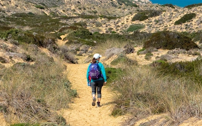
Only about an hour from the Costa Brava and Barcelona's famous landmarks, the landscape changes entirely. Fresh mountain streams race down forested slopes, trails climb to the highest peaks of Montseny, and the jagged rock towers of Montserrat rise dramatically above ancient monasteries. Walking in Catalunya – Barcelona by Nike Werstroh and Jacint Mig covers 32 day walks ranging from 6.5 to 28km, spread across five distinct natural parks and areas all within easy reach of the city. (Last updated: June 2026 · Guidebook edition: 1st edition, November 2022)
Walking in Catalunya - Barcelona, quick facts:
- Total routes: 32 circular, linear and return day walks
- Distance range: 6.5km to 28km (4 to 17 miles)
- Typical duration: 2 to 8 hours per walk
- Areas covered: Montseny Natural Park; Vic and Guilleries-Savassona Natural Area; Sant Llorenç del Munt i l'Obac Natural Park; Montserrat Natural Park; Penedès and Garraf Natural Park
- Difficulty: Grade 1 (easy) to Grade 3+ (some easy scrambling); routes graded throughout
- Terrain: Forested ridges, rocky mountain summits, conglomerate rock formations, limestone karst, vineyard trails and reservoir paths
- Highest point: Turó de l'Home, 1706m (Montseny Natural Park)
- Navigation: Waymarked trails throughout; GR, PR-C and SL-C signage; 1:40,000 maps included; GPX files available to download
- Best season: Spring, early summer and autumn; most routes accessible year-round
- Guidebook:Walking in Catalunya – Barcelona by Nike Werstroh and Jacint Mig, 1st edition, Cicerone Press
Walking in Catalunya - Barcelona
Montserrat, Montseny and Sant Llorenç del Munt i l'Obac Nature Parks
£17.95
SALE
£15.26
32 varied walks among the rocky mountains, forested slopes and idyllic wine country that surrounds Barcelona. Routes range from 6.5 to 28km and cover Montseny, Vic and Guilleries-Savassona, Sant Llorenç del Munt i l'Obac, Montserrat and Penedès and Garraf.
More informationWhat is Walking in Catalunya – Barcelona?
Walking in Catalunya – Barcelona is a guidebook to 32 day walks in the Barcelona province of Catalunya, covering five distinct natural areas within roughly an hour of the city. The walks explore the forested peaks of the Montseny Natural Park, the serrated rock needles of Montserrat, the oak-covered ridges of Sant Llorenç del Munt i l'Obac, the dramatic Sau reservoir and cliff villages of Vic and Guilleries-Savassona, and the vineyard-covered hills of the Penedès and Garraf. Routes range from a short 6.5km stroll to a full-day 28km traverse, with grades from easy to challenging.
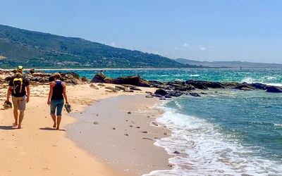
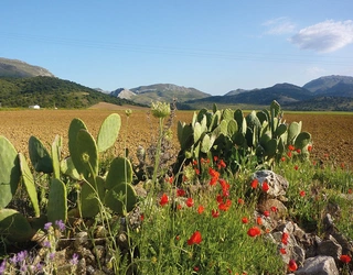
The landscape divides into two distinct characters. In the north, the Montseny massif, formed from schist and metamorphic rock, offers the highest summits and the lushest forests, with beech and oak giving way to subalpine meadows near the peaks. To the south and west, the spectacular conglomerate formations of Montserrat, shaped by millions of years of erosion, provide a labyrinth of rock towers and hidden hermitages. The Garraf Natural Park adds a third texture: limestone karst with typical Mediterranean coastal vegetation, close enough to Barcelona that some of the city's famous skyline is identifiable from the summit of La Morella.
Catalunya has its own language and a distinctive cultural identity that has shaped the landscape as much as geology. Benedictine monasteries occupy panoramic ridges, ruins of medieval castles and watchtowers stand above vineyards, and the long-distance GR 5 threads all five natural parks together in a single 200km route. This planning guide answers the most common questions walkers have before setting out. For complete walk-by-walk route descriptions and 1:40,000 mapping, see the Cicerone Walking in Catalunya – Barcelona guidebook.
The 32 walks at a glance
The guidebook organises its 32 walks across five geographic chapters, making it straightforward to plan days out from a single base or to combine areas over a longer trip.
Montseny Natural Park (Walks 1–10) contains the highest and most demanding routes, including the ascent of Turó de l'Home (1706m) and the various approaches to Matagalls. Distances range from 6.5km to 19.5km and grades from 1 to 3+.
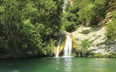
Vic and Guilleries-Savassona Natural Area (Walks 11–15) offers quieter, more rural walking, with highlights including the Sau reservoir, the cliff village of Tavertet and the Benedictine monastery of Sant Pere de Casserres. Walks range from 7km to 11km at grades 1 to 3.
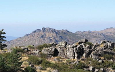
Sant Llorenç del Munt i l'Obac Natural Park (Walks 16–21) centres on the monastery at La Mola and offers excellent views towards both Montserrat and Montseny. Distances run from 6.5km to 10.5km at grades 1 to 3.
Montserrat Natural Park (Walks 22–27) includes multiple approaches to the iconic monastery and the summit of Sant Jeroni, the highest peak in the range. Routes range from 6.5km to 12km at grades 2 to 3.
Penedès and Garraf Natural Park (Walks 28–32) provides the most varied walking, from the vineyard trails and castle ruins of the Penedès to the rugged limestone landscape of the Garraf. Routes run from 9km to 28km at grades 1 to 3.
| Walk | Route type | Distance | Time |
|---|---|---|---|
| Turó de l'Home | Circular from Santa Fe | 11.5km | 4hr |
| Turó de Morou | Circular from Santa Fe | 6.5km | 2hr |
| Gualba to Santa Fe | Linear | 9.5km | 3hr 30min–4hr |
| Marianegra waterfall | Circular | 11.5km | 3hr 30min–4hr |
| Les Agudes | Circular | 8km/8.5km (variant dependent) | 4hr |
| Matagalls (Coll de Bordoriol) | Circular | 10km | 3hr 30min–4hr |
| Sant Bernat/Sant Marçal | Circular | 12km | 5hr–5hr 30min |
| Aiguafreda | Circular | 16km | 4hr 30min |
| Matagalls (Collformic) | Circular | 11.5km | 4hr–4hr 30min |
| Viladrau to Matagalls | Return | 19.5km | 6hr |
| Castell de Taradell | Circular | 10km | 3hr 30min |
| Tavèrnoles to Sant Pere de Casserres | Linear | 11km/8km (variant dependent) | 3hr 30min–4hr/3hr–3hr 30min |
| Puig del Far | Circular | 8km | 3hr |
| Pont de Malafogassa | Return | 7km | 2hr–2hr 30min |
| Tavertet | Circular | 11km | 4hr 30min–5hr |
| Sant Miquel del Fai | Circular | 7km | 2hr 30min |
| Montcau/Cova Simanya | Circular | 9km | 4hr |
| Castellasa | Circular | 8.5km | 3hr–3hr 30min |
| La Mola | Circular | 10.5km | 3hr 30min |
| Alzina del Salari | Circular | 8km | 2hr 30min–3hr |
| Coll d'Estenalles to Mura | Linear | 9km | 3hr |
| Montserrat Monastery | Circular | 8.5km | 3hr |
| Sant Jeroni | Circular | 10.5km | 3hr 30min–4hr |
| Ermita de Sant Joan | Circular | 6.5km | 2hr 30min |
| Roca Foradada | Circular | 9km | 3hr 30min–4hr |
| Els Pallers | Circular | 8km | 2hr 30min |
| Montserrat Monastery (Collbató) | Return | 12km | 4hr–4hr 30min |
| Garraf to Bruguers | Linear | 16km | 4hr 30min–5hr |
| Jafra | Circular | 9km | 2hr 30min–3hr |
| Castells de Marca | Circular | 28km | 8hr–9hr |
| Foix river gorge | Circular | 9.5km | 3hr–3hr 30min |
| El Montmell ridge | Circular | 9km | 3hr–3hr 30min |
The most demanding walk in the book is the Viladrau to Matagalls return (Walk 10) at 19.5km with 1120m of ascent and a six-hour round trip. The gentlest is the Turó de Morou circuit from Santa Fe (Walk 2), just 6.5km with only 270m of ascent and a two-hour round trip, making it a fine introduction to the Montseny Natural Park.

Who is Walking in Catalunya – Barcelona suitable for?
The guidebook is well suited to day walkers of varying experience, with routes graded 1 to 3+ to accommodate everyone from families and casual walkers to those looking for a proper mountain day out. Walkers based in Barcelona can use public transport to reach many of the starting points, and most of the linear routes are short enough that retracing your steps is a realistic option.
Grade 1 and 2 walks are accessible to anyone with a reasonable level of fitness and a pair of comfortable hiking boots. The Grade 3 routes involve longer distances, more ascent, or more demanding terrain, and require a higher fitness level and confident footwork. Walk 5 (Les Agudes) is graded 3+, requiring some easy scrambling and hands-on movement along the ridge. None of the walks in the book require technical climbing skills or specialist equipment.
Families with older children will find plenty of suitable routes in the Grade 1 and 2 bracket, particularly in the Vic and Guilleries-Savassona section and the lower Penedès walks.
How difficult is Walking in Catalunya – Barcelona?
The guidebook uses a four-level grading system: Grade 1 (easy, little ascent), Grade 2 (moderate, medium to longer distance on easy terrain), Grade 3 (longer or more difficult terrain), and Grade 3+ (easy scrambling required). The grading is an indicator only; mountain conditions can make any route more demanding, and clouds can arrive quickly on the higher Montseny summits, reducing visibility significantly.
Navigation is generally straightforward, as the routes make use of the region's well-established GR, PR-C and SL-C waymarked trail network. The guidebook always specifies which waymark colours and trail numbers to follow, and flags any sections where the described route uses an unmarked or cross-marked path.
When is the best time to walk in Catalunya?
Spring (March–May): The best season for most of the walks in the book. Temperatures are mild, wildflowers bring colour to the meadows, and the mountains are lush and green after winter rains. Orchids, including bee orchids, can be found on Montseny's slopes in spring.
Early summer (June): Still excellent before the heat builds. Longer days allow for more ambitious itineraries.
High summer (July–August): The Montseny Natural Park remains famously cooler than Barcelona and the coast, and its trails attract city day-trippers seeking refuge from the heat. The Penedès, Garraf and lower Montserrat walks are best avoided in the hottest months, when temperatures can be extreme and shade is limited.
Autumn (September–November): Spectacular for colour, particularly the chestnut slopes of Montseny. Some rainy days are possible, but September in particular offers excellent conditions. Mushroom season is a local highlight.
Winter (December–February): Most routes remain accessible, though the chance of snow on the higher Montseny peaks means extra preparation is wise. Snow is rare but not unknown.

What accommodation is available?
The region offers a wide range of accommodation to suit different budgets, from hotels and self-catering apartments in the coastal areas to rural houses (casas rurales) and campsites with self-catering bungalows in the natural parks. The growing interest in rural tourism has expanded the options considerably in recent years.
A useful approach is to choose one or two bases and take day trips from them, as many areas are easily reached within an hour. Barcelona itself is an obvious hub for the more accessible walks, with Sant Celoni convenient for Montseny, Vic for the Guilleries-Savassona area, and Manresa or Monistrol de Montserrat for the Montserrat walks.
For a full list of campsites in the region, see Appendix C in the guidebook. The official guide to tourism establishments in Catalunya is available at establimentsturistics.gencat.cat.
Getting to and around Catalunya
Barcelona is the gateway to the region and is well connected to UK and European airports, with numerous airlines offering direct flights. From Barcelona, the Estació de Sants mainline station serves suburban and national rail routes, with regular services to major towns including Monistrol de Montserrat, Vic and Granollers, all close to the trails.
For many walks, a combination of train and local bus is possible, though rural bus services are infrequent. The guidebook notes where buses serve linear walk endpoints, but it is strongly advised to check timetables locally before setting out. A hire car collected at Barcelona airport gives the most flexibility and is the most practical option for exploring across several areas during a single trip. Many trailheads have parking.
What are the route highlights?
- Montserrat Monastery and Sant Jeroni (Walks 22–27): the iconic monastery surrounded by extraordinary conglomerate rock formations, with a 360-degree panorama from the summit of Sant Jeroni, the highest peak in the range
- Turó de l'Home and Les Agudes (Walks 1, 5): the highest summits in the Montseny Natural Park with far-reaching views towards the Pyrenees on a clear day
- Tavertet and the Sau reservoir (Walks 14–15): dramatic cliff-top village above the flooded valley, with griffon vultures often visible soaring on the thermals
- La Mola and Sant Llorenç (Walks 17–19): the landmark monastery on the highest peak of the Sant Llorenç del Munt i l'Obac Natural Park, with views spanning both the Montserrat range and the Montseny massif
- Castells de Marca trail (Walk 30): a full-day 28km route through the Penedès wine country, linking medieval castle ruins and watchtowers above the vineyards
- Sant Pere de Casserres (Walk 12): a Benedictine monastery in a stunning position overlooking a bend in the river Ter, reached via a section of the long-distance Oliba Trail
Plan your walk with the Cicerone guidebook
The Cicerone Walking in Catalunya – Barcelona by Nike Werstroh and Jacint Mig contains everything you need to plan and complete all 32 walks, from the wooded peaks of Montseny to the vineyard trails of the Penedès.
- 32 walks ranging from 6.5 to 28km, organised across five geographic areas, all accessible from Barcelona
- 1:40,000 maps included for every walk, with GPX files available to download free from the Cicerone website
- Detailed route descriptions with GPS coordinates for each trailhead and waymark information for GR, PR-C and SL-C trails throughout
- Grading system (1 to 3+) with a complete route summary table to help you choose walks to match your fitness and available time
- Practical sections covering getting there and around, accommodation options, seasonal advice, language, and a Catalan-Spanish-English glossary
- Information on the region's wildlife and botany, including the critically endangered Montseny brook newt, found nowhere else in the world
Available as a printed guidebook (£17.95) or digital eBook (£17.95).
Walking in Catalunya - Barcelona
Montserrat, Montseny and Sant Llorenç del Munt i l'Obac Nature Parks
£17.95
SALE
£15.26
32 varied walks among the rocky mountains, forested slopes and idyllic wine country that surrounds Barcelona. Routes range from 6.5 to 28km and cover Montseny, Vic and Guilleries-Savassona, Sant Llorenç del Munt i l'Obac, Montserrat and Penedès and Garraf.
More informationAbout Nike Werstroh and Jacint Mig, guidebook authors
Nike and Jacint met many years ago on a long coach journey as they both travelled into the unknown to build a new life in a different country. It wasn't long before they became inseparable. Travelling quickly emerged as their favourite activity and now wherever they go they try to find the best trails. They would love to share their passion for walking with others. Nike went to journalism school and Jacint is a keen photographer. Nike and Jacint live in Guildford and when they are not walking in one of their favourite mountain ranges somewhere in Europe, they enjoy exploring the diverse trails in the Surrey Hills close to their home. And when they are not out walking they offer a personalised travel planning service, details of which can be seen on Nike and Jacint's website www.trailnotes.co.uk.