Escaping wildfire on Greenland’s Arctic Circle Trail
The remote Arctic Circle Trail had long been on Peter Watson’s bucket list. This summer he finally made it to Greenland’s hinterland, only to be stopped in his tracks by something completely unexpected.
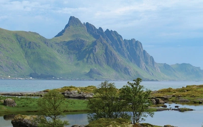
Greenland is home to some of the planet’s last true wilderness. Much of the country’s land surface is frozen year-round, but to the southwest lies a large tract of Arctic tundra that stays ice-free, and thus navigable, throughout the summer.
Known as ‘the land of a hundred lakes’, the area is home to some of the most remote backcountry on Earth. Fortunately, a fine hiking trail courses its way across the steppe, running from Greenland’s infamous ice cap to its wet and wild western seaboard.
At 165km (103 miles), the Arctic Circle Trail (ACT) is the longest waymarked trail in Greenland. The trail begins in Kangerlussuaq and finishes at the coastal town of Sisimiut, usually taking between seven and 10 days to complete. It can be walked in either direction, but most choose to begin in Kangerlussuaq and walk westwards towards the sea. As the trail grows in popularity, however, more trekkers are choosing to start from Sisimiut.
The ACT traverses one of the largest ice-free areas of Greenland, which is notable given that 80% of the nation’s landmass is covered in ice and largely inaccessible. The trail lies entirely within the Arctic Circle, 40-50km to the north of the legendary circle of latitude.
The ACT is one of the most remote hiking trails in the world and, as such, attracts only around 1500 hikers every year – although that figure is slowly creeping up. The ACT does not cross any towns or settlements so once away from Kangerlussuaq, trekkers must be entirely self-sufficient and carry everything they will need for several days in the wilderness.
Across the silent tundra
I began my trek in the lonely town of Kangerlussuaq. With a population of around only 500, an international airport and a clutch of prefabricated buildings, Kangerlussuaq isn’t a destination in itself, so I was keen to get going and onto the trail.
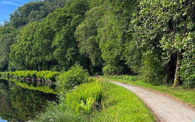
The initial march out of town is along a dusty dirt road that runs parallel to the Kangerlussuaq fjord. By mid-afternoon, I had left the road and was climbing into the expansive landscape the trail is known for: glinting glacial lakes, boulder-strewn moraine and domed hills covered with low-growing shrub. By the end of the first day I was camped on the calm shores of Limnaesø Lake.
As the days passed, life on the trail quickly eased into a fulfilling and tranquil routine. The route is broken down into hut-to-hut sections of around 20km. However, I chose to camp most nights so usually walked beyond the huts. I typically took a lunch break at a hut – the ideal place to meet other hikers or even take a brief nap.
Usually, I pitched my tent in the early evening, always beside a lake, before eating my dehydrated trekking meal, a squashed chocolate bar for dessert and having a hot drink to round things off. The rest of my evening was spent studying the guidebook and planning the ensuing day’s route.
It was silent and it was bliss. There is no mobile phone reception, no internet, barely any people on the trail and therefore few distractions. At most, only the occasional wildlife sighting would interrupt my thoughts: a reindeer wandering up to my campsite, a hare skipping across the trail or an Arctic fox darting into its burrow.
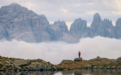
After four days of walking, somewhere just beyond Ikkattooq hut, I reached the halfway point of my trek. To my knowledge, it was the furthest from civilisation I’d ever been. The nearest settlement was over 80km away, I hadn’t encountered another person in two days and I hadn’t seen darkness since leaving home. This was true isolation.
There is something wonderfully primal about disconnecting from the world. The mind clears completely. Cairn-spotting and route-finding dominated most of my thoughts, interrupted only by internal discussions on where best to refill a water bottle, pitch my tent or which dehydrated meal to eat tonight: vegetable hot pot or pasta again?
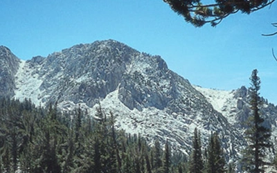
The terrain varied from day to day, valley to valley. During the early days, the landscape was generally mellow, with the trail undulating between low-lying hillocks and small lakes. As the trek progressed, the topography became more rugged, the valleys deeper and the lakes longer and wider.
Hillocks soon became mountains and the trail more strenuous. Fortunately, my pack was also getting lighter as I consumed more and more of my supplies. On the third day, I took a canoe 20km along Amitsorsuaq Lake, which proved a wonderful respite from tramping its shoreline.
Trouble on the horizon
On the seventh day of my trek I arrived at Innajuattoq hut, delightfully positioned at the head of a lake. The day was calm and utterly still, which meant the steep-sloped valley was serenely reflected in the lake’s mirror-like waters. It was late morning and I was making good time and feeling strong so decided to push on to the next hut at Nerumaq and shave a day off my itinerary. The thought of a hot shower and a big meal at Sisimiut the following day convinced me to continue.
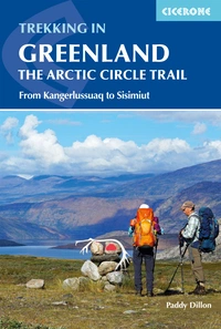
Trekking in Greenland - The Arctic Circle Trail
From Kangerlussuaq to Sisimiut
£18.95
A comprehensive guidebook for hiking the Arctic Circle Trail, which crosses the largest ice-free area of West Greenland, 25-30 miles north of the Arctic Circle. At just over 100 miles long, and taking 7 to 10 days to complete, this splendid backpacking route runs from Kangerlussuaq to Sisimiut - both with airport access.
More informationAs I made my way along the Nerumaq valley I met a couple of hikers coming in the opposite direction. They told me of a small peat fire they had seen in the preceding valley.
‘It’s nothing to worry about,’ they casually remarked. ‘It just rather spoils the view.’
On I went, unconcerned, continuing to make good time. As the kilometres ticked by, I became aware of a haze creeping into the valley ahead of me. I remained unfazed by the scene and didn’t even bother to take a photograph. As the couple had said, it just seemed to spoil the view somewhat, but no alarm bells were ringing.
Just before the Nerumaq hut, the valley and trail swung to the right and towards the smoke’s source. As I approached the turn, the smoke began to noticeably thicken. Here, I encountered another hiker who had been in the vicinity for over an hour. He was clearly anxious.

The hut, our final destination for the day, could no longer be located due to the dense smoke. Furthermore, the area in which we were standing was quickly filling with fumes. Calmly, we decided to retreat and camp some way back and see if we could continue in the morning. However, heavy smoke soon began surrounding us and it became clear that we could not stay where we were.
Still intent on completing the trek, we studied the map and decided we might be able to hike over a mountain ridge into an adjacent valley and then rejoin the trail. Thirty minutes later we had scrambled some distance up the valley side. Looking back, we could no longer see the valley floor in which we’d just been standing. It was now a carpet of sinister smoke.
Another hour passed as we struggled to gain the ridge and see into the adjacent valley. Our hearts sank. It was worse than the valley we’d climbed from. We were now trapped, surrounded by smoke-filled valleys on three sides and high mountains on another. I realised that it was no longer a matter of how to rejoin the trail, but of how to escape.
Fortunately, we had an emergency satellite phone, so we considered the options at hand. We decided to wait an hour and see if the situation improved, but within just a few minutes, the smoke around us thickened significantly and we both started coughing. We had no choice but to request an emergency rescue.
The response was outstanding. Within an hour we were collected by an emergency response helicopter stationed at the Danish Arctic Command base at Kangerlussuaq. Within three hours we were in Kangerlussuaq – back where I started my trek a week earlier. It was an abrupt and disheartening end to what had been a captivating trek.
We were both deeply disappointed, but also profoundly thankful to be alive and well enough to tell the tale. We were, and are, extremely grateful to the Greenland rescue services for their help and support throughout.
An unprecedented season in the North
I planned for a number of eventualities for my trek in Greenland. I bought waterproof maps and a detailed guidebook, downloaded the latest topographical maps onto my GPS and studied endless trip reports and blogs. I topped up my first aid kit with bandages, ointments and medicines to treat all the ailments I could imagine. I packed extra food and snacks in case I couldn’t keep to my planned program.
Finally, I packed layers of warm and waterproof clothing. This was the Arctic after all and, despite it being mid-July, I knew that I should expect everything from blue skies to snowstorms.
What I didn’t plan for – what never crossed my mind – was wildfire. I was heading to the Arctic for goodness sake; to Greenland of which 80% is covered in ice! Fire was a hardly a danger. Only, it turns out, it was and is.
I’ve now learnt that one of the coldest places on the planet is not necessarily one of the wettest. Throughout my trek I didn’t see a single drop of rain. Instead, the days were long, hot and dry.
The Arctic is also home to the second largest desert in the world after Antarctica. Unlike Antarctica, however, the Arctic has flammable vegetation including willow forests, grasslands and shrubs, often situated in peat bogs baked dry by 24 hours of daylight.
This year saw unprecedented wildfires in the Arctic, with over 100 breaking out in the worst season the region has ever experienced. Generally, it is unusual to see this level of ferocious and sustained fires at such high latitudes.
However, temperatures in the Arctic are warming faster than any other region on Earth. These warmer conditions encourage fires to grow and persist once ignited. The parched ground conditions (such as the thawed, dried peat bogs I encountered on the ACT) combined with hotter than average temperatures create the perfect conditions for wildfires.
Wind of change
A wind of change is blowing through this part of the world and it’s blowing harder and faster than across the rest of the planet. The issue of climate change in the Arctic has been well documented – we’ve all heard of rising sea levels and melting ice caps.
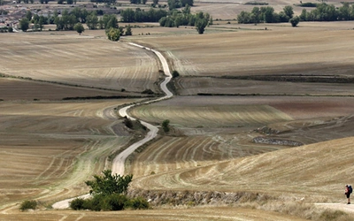
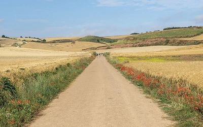
The ice melt in Greenland is revealing more and more vegetation, which will only create more fuel for the summer wildfires that swept the region this year. Wildfires in Greenland will become more commonplace. This year the ACT was repeatedly rerouted, with a southern section opened for trekkers to avoid the affected areas.
Trails and trekkers will have to adapt along with a changing climate. New routes will have to be developed and trekkers will have to be more prepared. Growing up in the UK, I never considered wildfire as a threat when out in the hills. However, throughout Europe and the UK wildfires are becoming more prominent. The UK now sees four times more land burned than during the previous decade. Trekkers should be versed in how to evade wildfire, be aware of escape routes and carry an emergency beacon or satellite phone.
Fortunately for me, my trek through Greenland’s Arctic tundra still largely elicits happy memories: wild and remote mountainous backcountry, steep verdant valleys, gleaming glacial lakes and sweeping Arctic tundra. But unfortunately, it did leave a somewhat stale taste in my mouth.