The GR5 Trail – Vosges and Jura: a complete planning guide
Imagine a landscape of rolling hills and deeply cut gorges, of ruined castles, villages with half-timbered houses, and a network of footpaths weaving through forests. That is how Les and Elizabeth Smith introduce the central section of the GR5, and it captures the appeal precisely. The GR5 Trail – Vosges and Jura covers 687km (427 miles) from Schirmeck in the northern Vosges to Nyon on the shores of Lake Geneva, passing through some of the most rewarding and least-visited walking country in France. Otherwise known as the central section of the GR5 (which in its entirety goes from the North Sea to the Mediterranean), the route takes five to six weeks to complete, though even a few days on the trail introduces you to these enchanting places. (Last updated: June 2026 · Guidebook edition: 2nd edition, 2017)
The GR5 Trail – Vosges and Jura, quick facts:
- Distance: 687.5km / 427 miles (GR5 + GR53 combined); 518km / 322 miles (GR5 only, Schirmeck to Nyon)
- Duration: 5–6 weeks (full route); shorter sections easily achieved
- Start: Schirmeck, France (or Wissembourg via the GR53 link)
- Finish: Nyon, Switzerland (Lake Geneva / Lac Léman)
- Sections: 11 GR5 sections + 3 GR53 sections (plus 8 described short walks)
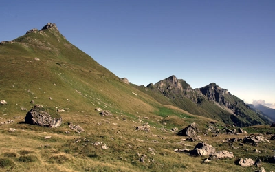
- High point: Ballons des Vosges (southern Vosges summits, above 1400m); plateau of the Haut-Jura around 1000m
- Difficulty: Moderate; suitable for any reasonably fit walker. Some sections are rough and exposed
- Terrain: Sandstone forest and castle ridges (Northern Vosges), open summit pastures and Alsace wine villages (Southern Vosges), wooded gorges, limestone plateau and cliff-edge paths (Jura)
- Waymark: Red rectangles (GR53 and Vosges section of GR5); white over red rectangles (GR5 in the Jura); yellow diamonds (final section in Switzerland)
- Accommodation: Hotels, chambres d'hôtes, gîtes d'étape, refuges, campsites
- Best season: May to October; snow possible on higher sections before April
- Guidebook:The GR5 Trail – Vosges and Jura by Les and Elizabeth Smith, 2nd edition 2017
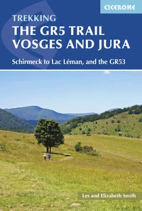
The GR5 Trail - Vosges and Jura
Schirmeck to Lac Léman, and the GR53
£16.95
Guidebook to a 687km (427 mile) trek through eastern France, traversing the Vosges and the Haut-Jura plateau. The route follows the GR53 from Wissembourg to Schirmeck, before picking up the central section of the GR5 from Schirmeck to Nyon on Lake Geneva, taking in wooded and grassy hills, river gorges and fascinating castle ruins.
More information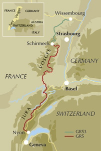
What is the GR5 Trail – Vosges and Jura?
The GR5 Trail – Vosges and Jura is the central section of the Grande Randonnée 5, one of the great long-distance walking routes of Europe, which runs for approximately 2300km from the North Sea coast to the Mediterranean at Nice. This guidebook covers two connected routes: the GR5 itself (518km from Schirmeck to Nyon on Lake Geneva) and the GR53 (169.5km from Wissembourg to Schirmeck), which allows walkers to complete the entire chain of the Vosges from north to south. Together they cover 687.5km of the most varied and historically layered walking country in France.
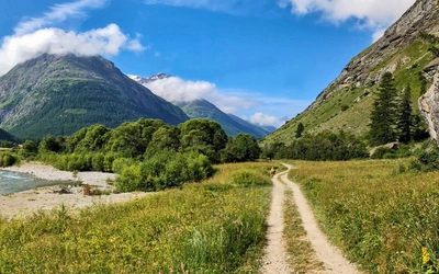
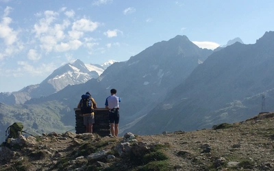
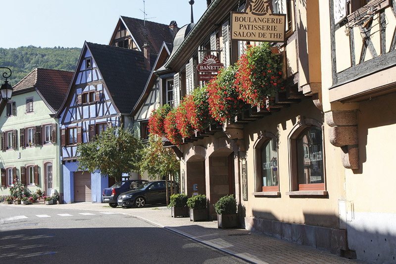
The landscape shifts dramatically across the route. In the Northern Vosges, the trail threads through tranquil sandstone forests past medieval castle ruins perched on rocky pinnacles. Southward through the Central and Southern Vosges, the rock changes to gneiss and granite, the summits open up into wide pastures, and the lower slopes are draped in the famous Alsace vineyards with their cobbled villages. Then, at the edge of the Vosges, the Jura begins: limestone country where rivers have cut deep gorges, waterfalls thunder through rocky defiles, and the high plateau stretches to the horizon before the path finally drops to Lake Geneva with views across to the distant Alps.
What makes this section distinctive is that it crosses genuinely different geological and cultural worlds within a single continuous route. The Vosges have been a contested Franco-German border for centuries, and the trail passes World War I trenches, old frontier stones and the ridge lines where the fighting was fiercest. The Jura, by contrast, feels remote and unhurried, a landscape of smoked meats, yellow wine and trout in shaded pools. This is not a route that rushes you from one postcard view to the next; it rewards walkers who take the time to notice the detail.
This planning guide answers the most common questions walkers have before setting out. For complete section-by-section route descriptions and mapping, see the Cicerone GR5 Trail – Vosges and Jura guidebook.
Why does Cicerone have three GR5 guidebooks? Which one do I need?
The GR5 is approximately 2300km long, making it impossible to cover in a single practical guidebook. Cicerone divides the full trail across three volumes, each covering a distinct section with its own character, difficulty level and logistics:
| - | GR5 – Benelux and Lorraine | GR5 – Vosges and Jura | GR5 – Through the French Alps |
|---|---|---|---|
| Start | Hoek van Holland | Schirmeck (or Wissembourg via GR53) | Lake Geneva (Lac Léman) |
| Finish | Schirmeck | Lake Geneva (Lac Léman) | Nice (or Menton via GR52) |
| Distance | ~1000km / 621 miles | 687.5km / 427 miles (incl. GR53) | ~600km / 373 miles |
| Duration | 6–8 weeks | 5–6 weeks | 4–5 weeks |
| Countries | Netherlands, Belgium, Luxembourg, France (Lorraine) | France (Vosges, Alsace, Jura), Switzerland (final approach to Nyon) | France (Alps), with optional GR52 finish through Mercantour |
| Terrain | Flat to gently hilly; polders, heath, river valleys, plateau | Forested hills, sandstone ridges, open summits, river gorges, limestone plateau | High mountain terrain; passes, glacial valleys, national parks |
| Difficulty | Easy to moderate | Moderate | Challenging; serious alpine fitness required |
| Author | Carroll Dorgan | Les and Elizabeth Smith | Paddy Dillon |
| Sections/Stages | 49 stages | 11 GR5 sections + 3 GR53 sections | 28 stages |
If you are planning to walk the full GR5 end-to-end, you will need all three volumes: the Benelux and Lorraine book takes you from the North Sea to Schirmeck, this book carries you through the Vosges and Jura to Lake Geneva, and the French Alps volume brings you down to the Mediterranean. If you are planning a section walk, choose the volume that covers your intended start and finish points using the table above.
How long is the GR5 Trail – Vosges and Jura? The sections
The route is divided into 14 sections in total: three covering the GR53 from Wissembourg to Schirmeck, and eleven covering the GR5 from Schirmeck to Nyon. Sections are longer than typical daily stages on other routes, covering distances that most walkers will split across two or more days.
GR53: Wissembourg to Schirmeck
| Section | Distance | Ascent/Descent | Time |
|---|---|---|---|
| 1 - Wissembourg to Niederbronn-les-Bains | 45km (28 miles) | 1390m / 1370m | 14hr 35min |
| 2 - Niederbronn-les-Bains to Saverne | 54km (33.5 miles) | 1250m / 1240m | 17hr |
| 3 - Saverne to Schirmeck | 70.5km (44 miles) | 2260m / 2130m | 23hr |
| GR53 Total | 169.5km (105.5 miles) | 4900m / 4740m | 54hr 35min |
GR5: Schirmeck to Nyon
| Section | Distance | Ascent/Descent | Time |
|---|---|---|---|
| 4 - Schirmeck to Ribeauvillé | 86.5km (54 miles) | 2730m / 2810m | 28hr |
| 5 - Ribeauvillé to Mittlach | 54km (33.5 miles) | 2060m / 1770m | 18hr |
| 6 - Mittlach to Thann | 40.5km (25 miles) | 1170m / 1360m | 13hr 10min |
| 7 - Thann to Brévilliers | 68.5km (42.5 miles) | 1740m / 1715m | 21hr 50min |
| 8 - Brévilliers to St-Hippolyte | 47km (29 miles) | 860m / 780m | 13hr 50min |
| 9 - St-Hippolyte to Villers-le-Lac | 71km (44 miles) | 1470m / 1260m | 21hr 45min |
| 10 - Villers-le-Lac to Les Hôpitaux-Neufs | 64km (39.5 miles) | 1460m / 1190m | 19hr 45min |
| 11 - Les Hôpitaux-Neufs to Nyon | 86.5km (53.5 miles) | 1170m / 1740m | 27hr 55min |
| GR5 Total | 518km (322 miles) | 12,660m / 12,625m | 164hr 15min |
| Combined Total | 687.5km (427 miles) | 17,560m / 17,365m | 218hr 50min |
The longest sections are Section 4 (Schirmeck to Ribeauvillé, 86.5km, 28hr) and Section 11 (Les Hôpitaux-Neufs to Nyon, 86.5km, 28hr), both of which most walkers will take four to five days to complete. The Jura sections (9 and 10) are noted in the guidebook as the most poorly served by local transport, so it is worth planning to walk them consecutively if possible.
Who is the GR5 – Vosges and Jura suitable for?
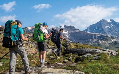
The route is well within the capabilities of any moderately fit walker who has some experience of multi-day walking with a full pack. It is not technically demanding: there is no scrambling or climbing, and the waymarking is generally reliable. However, some sections are rough and exposed, and the cumulative ascent and descent figures are substantial: the full route involves more than 17,500m of climbing.
The Vosges sections are more forgiving than the Jura, with well-maintained forest paths and regular villages offering accommodation and refreshment. The Jura plateau is wilder and more remote, with some sections where a walker might carry food for a day or two between resupply points. Anyone new to long-distance walking would benefit from a few trial days with a full pack before setting off, particularly for the southern sections.
The route is not well-suited to families with young children as a continuous trek, but individual sections (particularly the Alsace wine village stages in Sections 4 and 5) work well for shorter outings. Dog walkers will find the forest sections generally suitable, though some gîtes d'étape and refuges may not accept dogs.
How difficult is the GR5 – Vosges and Jura?
Overall difficulty is moderate, with some variation across the route:
- GR53 (Northern Vosges, Sections 1–3): Gentle, forested ridges with sandstone outcrops. The longest section by time (Section 3, 23hr) involves the most ascent but nothing technically hard. These quiet hills are often the personal favourite of authors Les and Elizabeth Smith.
- Vosges GR5 (Sections 4–7): The terrain becomes bigger and more open on the Ballons des Vosges (higher summits above 1400m). Section 4 is the most committing, covering 86.5km with nearly 2800m of descent from the massif. The vineyard villages of Alsace provide excellent staging points.
- Transition zone (Section 8): Lower, gentler country around Belfort and Brévilliers. The rock changes from Vosgien to limestone here.
- Jura (Sections 9–11): Wilder and more demanding logistics than the Vosges. Sections 9 and 10 are long and remote, local bus services are sparse, and Villers-le-Lac (the end of Section 9) is no longer served by a bus at all, making a taxi from Morteau the practical option. The cliff-edge path above Le Mont d'Or in Section 11 is the scenic high point of the Jura.
Navigation is generally straightforward on the Vosges sections. The Jura waymarking can be confusing where the GR5 and GTJ (Grand Traversée du Jura) share the same red-and-white marks, so carrying the guidebook alongside a detailed map is advisable. Note also that the waymarking changes to yellow diamonds for the final Swiss section approaching Nyon.
Can I walk a shorter section of the GR5 – Vosges and Jura?
Yes, and the guidebook's section structure is designed with this in mind. The outline at the start of each section summarises highlights and walking conditions, helping you choose between sections if you are planning a shorter trip.
The most popular standalone sections are:
- GR53 Northern Vosges (Sections 1–3, ~170km): Wissembourg to Schirmeck. Tranquil forests, sandstone castle ruins, few other walkers. A week to ten days.
- Alsace and Southern Vosges (Sections 4–6, ~181km): Schirmeck to Thann. The most dramatic Vosges terrain, passing through the wine villages of Ribeauvillé and Mittlach. Ten days to two weeks.
- Jura gorges and plateau (Sections 9–10, ~135km): St-Hippolyte to Les Hôpitaux-Neufs. The Doubs gorge (a highlight of the entire GR5), Joux Castle and the limestone plateau. Eight to ten days.
The guidebook also describes eight short circular walks along the GR5/GR53, ranging from 9km to 21.5km, for walkers who want to sample specific landscapes without committing to a multi-day trek.
Access is easier from the northern end: Wissembourg, Niederbronn-les-Bains, Saverne and Schirmeck all have rail connections. The Jura sections are more difficult to access; the guidebook details the options at the start of each section.
Which direction should I walk the GR5 – Vosges and Jura?
The route is described north to south (Wissembourg or Schirmeck to Nyon), and this is the direction almost all walkers choose. It follows the natural grain of the GR5 as a whole, picking up from the Benelux and Lorraine section in the north and handing on to the French Alps section at Lake Geneva in the south. Walking into the mountains, with the Alps growing on the horizon, is also more satisfying than walking away from them.
Walking south to north is possible, but would place the most remote and transport-poor Jura sections at the start of the trip, which is a harder introduction to a long route.
When is the best time to walk the GR5 – Vosges and Jura?
The best walking season runs from May to October, with the following considerations:
- May to June: The trails are quiet and the forests lush. Snow can linger on the higher Ballons des Vosges into May in a late year, so check conditions before attempting the summit sections. Lily-of-the-valley, wild narcissus and globe flowers are at their best on the open pastures.
- July to August: The main holiday season. Popular centres (Ribeauvillé, Mittlach, Villers-le-Lac) can be busy, and accommodation in the Vosges wine villages in particular may need advance booking. Hot, but not generally too hot for walking at altitude.
- September: Often the sweet spot. Quieter trails, the bilberry harvest underway, autumn colour beginning in the forests. The Alsace wine harvest adds atmosphere to the lower villages.
- October: Still walkable on the lower sections, but the higher Vosges can be cold and wet, and some refuges close. A good month for the gorge sections of the Jura.
- November to April: The higher sections of the Vosges are typically under snow from November to early April, and several refuges are only open during the skiing season. Walking at this time requires winter equipment and experience.
What is the historical significance of the Vosges and Jura route?
The Vosges range formed one of the most contested borders in European history for the better part of a century. After the Franco-Prussian War of 1870, Alsace was ceded to the German Reich and the ridge of the Vosges became the Franco-German frontier. Old frontier stones from this era run alongside the GR5 in Section 5. When war returned in 1914, the ridges and summits the trail now crosses became the front line: the GR5 passes close to the preserved World War I trenches and memorials at Le Linge and Hartmannswillerkopf on two separate occasions (Sections 5 and 6). Alsace finally returned to France in 1918, then was occupied again in 1940, with many Alsatian men conscripted into the German army and sent to the Russian front. It was retaken by the French during the winter of 1944–45.
The result of this history is that Alsace has a genuinely distinctive identity: French in language and administration, but with surviving Alsatian dialect, half-timbered architecture that feels more Rhineland than Parisian, and a culinary tradition built around choucroute, kugelhopf, and white wines with German-style grape variety names. Walking through the region on the GR5 gives a more layered sense of this than a visit to any single town would.
The Jura, while less dramatically contested, has its own historical depth: Joux Castle (Section 10), one of the most dramatically sited strongholds in France, stands guard over a narrow rocky gorge, and Nyon at the trail's end is a Roman foundation with origins dating to Caesar's campaigns south of the Vosges in 58BC.
What accommodation is available on the GR5 – Vosges and Jura?
The Vosges sections are well served; the Jura sections require more forward planning.
- Northern Vosges (GR53): Hotels and chambres d'hôtes in the larger towns (Wissembourg, Niederbronn-les-Bains, Saverne), gîtes d'étape and the occasional refuge in between. The forest sections have fewer options.
- Southern Vosges (Sections 4–7): Good variety in the Alsace wine villages. Fermes-auberges (farms offering simple meals based on local produce) are common in the Vosges but do not usually offer accommodation, so do not confuse these with gîtes d'étape.
- Jura (Sections 8–11): More remote. Refuges are an option in some areas, but many have restricted opening periods, are reserved for club members in high season, or are only available for group bookings. The guidebook makes a particular effort to identify accommodation on the more isolated stretches, and Appendix E lists contact details. Budget walkers can camp throughout, with wild camping (discreetly away from roads and houses) generally tolerated outside restricted areas, though not a legal right in France.
- Switzerland (final section): Swiss accommodation is considerably more expensive than French. A sleeping bag liner is worth having if using refuges or abris, which may offer little more than walls and a roof.
A full facilities table (Appendix C) and accommodation list (Appendix E) are included in the guidebook. For the most up-to-date information, regional tourist office websites are recommended alongside the guidebook listings.
Getting to the start and leaving from Nyon
Getting to Wissembourg or Schirmeck: The nearest major airports are Strasbourg, Basel and Geneva. TGV express trains from Paris serve Strasbourg and Basel. Wissembourg, Niederbronn-les-Bains, Saverne and Schirmeck all have French rail connections (SNCF). Strasbourg is the most practical hub for reaching the northern end of the route.
Leaving from Nyon: Nyon is on the Swiss rail network, with regular services to Geneva. From Geneva, onward connections to Paris, London (via Eurostar) and major European airports are straightforward. If continuing the GR5, the GR5 – Through the French Alps guidebook picks up at Lake Geneva and takes you south to the Mediterranean.
Along the route: Access along the Jura sections is notably more difficult than in the Vosges. Villers-le-Lac no longer has a bus service; the nearest rail stations are Morteau (7km) or Le Locle in Switzerland (8km). The guidebook notes that a taxi from Morteau may now be the most practical solution. Les Hôpitaux-Neufs has a connecting SNCF bus to Frasne station. The guidebook lists access details at the start of each section, and Appendix D provides useful transport websites.
What are the highlights of the GR5 – Vosges and Jura?
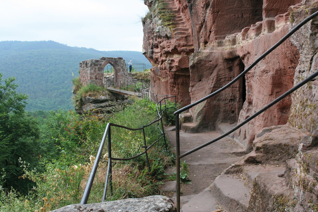
- Northern Vosges sandstone ridges (GR53, Sections 1–3): Quiet forests with castle ruins on rocky pinnacles, including a good selection within the boundaries of the regional park.
- Enigmatic ruins of the Mur Paien and Mont Ste-Odile (Section 4): Shrouded in legend, these are among the strangest monuments on the entire GR5.
- Alsace wine villages (Sections 4–5): Cobbled lanes, half-timbered houses, stork nests and white wine, particularly around Ribeauvillé.
- Hartmannswillerkopf and Le Linge battlefield memorials (Sections 5–6): The GR5 passes close to preserved World War I trenches on two occasions.
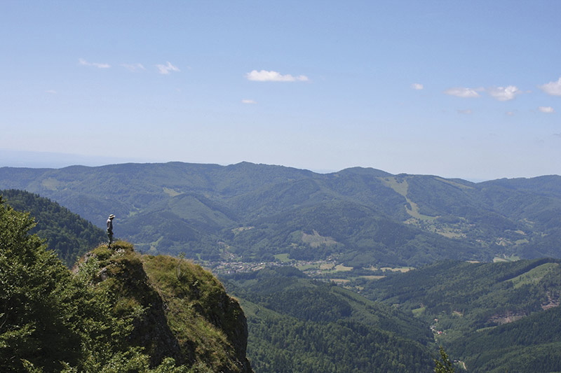
- Ballons des Vosges summits (Sections 5–6): The highest terrain on this section of the GR5, with panoramic views extending to the distant Alps on a clear day.
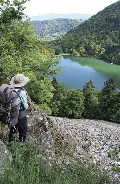
- Glacial lakes of the Vosges: Lac Blanc, Lac Noir and others lie just below the eastern cliffs of the massif.
- Saut du Doubs waterfall (Section 9): The thunder of water can be heard long before the fall comes into view. One of the great set pieces of the entire GR5.
- Doubs gorge (Section 9): The river flowing along the Swiss frontier through a series of wooded gorges, with trout in the shaded pools.
- Joux Castle (Section 10): One of the most dramatically sited strongholds in France, guarding a narrow rocky cleft.
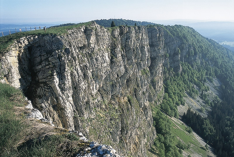
- Le Mont d'Or cliff-edge path (Section 11): Magnificent vantage points over the Swiss Jura, and chamois on the slopes below.
Plan your walk with the Cicerone guidebook
The GR5 Trail – Vosges and Jura by Les and Elizabeth Smith contains everything you need to plan and complete this central section of the GR5, from Wissembourg (or Schirmeck) to Nyon.
- 11 GR5 section descriptions (Schirmeck to Nyon) and 3 GR53 section descriptions (Wissembourg to Schirmeck), each with route overview, highlights, walking conditions notes, and suggested overnight stops
- Sketch maps throughout, with the relevant IGN map sheet listed at the start of each section
- 8 described short walks (9km to 21.5km) along the GR5/GR53, for walkers sampling the route on a day-walk basis
- Appendix A: Overview of other long-distance routes in the Vosges and Jura (GR531, GR532, GTJ, GR59)
- Appendix B: Full route summary tables with distances, ascent/descent figures and timings
- Appendix C: Facilities table, identifying resupply, refreshment and budget accommodation points along the route
- Appendix D: Useful websites including tourist offices, transport and map suppliers
- Appendix E: Accommodation list by section with contact details
Available as a printed guidebook (£16.95) or digital eBook (£16.95).
The GR5 Trail - Vosges and Jura
Schirmeck to Lac Léman, and the GR53
£16.95
Guidebook to a 687km (427 mile) trek through eastern France, traversing the Vosges and the Haut-Jura plateau. The route follows the GR53 from Wissembourg to Schirmeck, before picking up the central section of the GR5 from Schirmeck to Nyon on Lake Geneva, taking in wooded and grassy hills, river gorges and fascinating castle ruins.
More informationAbout Les and Elizabeth Smith, guidebook authors:
Les and Elizabeth Smith originally trained as a scientist and a geographer, and spent many years pursuing sensible careers. Their outdoor interests encouraged them to adopt a less secure but more flexible lifestyle, which allows them more time to explore the Scottish hills and travel further afield. Enthusiastic walkers and campers, they have backpacked along many long-distance routes, both in the UK and across Europe. Their trips often take them to less publicised areas, where a walking trail can be an excellent way to see the country and meet local people. They firmly believe that travelling and enjoying the outdoors does not depend on a generous budget.