This month, get 20% off selected guidebooks to the Alps. Browse participating guidebooks on our Special Offers page.
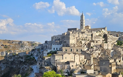
Klöster Säben on a hilltop above Klausen

The Keschtnweg: A chestnut walk in northern Italy

With few English-language guides to the area, and in the spirit of pioneering lesser-known paths, Kevin Thomas describes the Eisacktal chestnut path – Keschtnweg – in South Tyrol to try to get the antennae of other hikers twitching.

Planning the walk

I am sure you learn more about a place if you just stumble upon things you didn’t expect and take paths you were pretty clueless about before you began. My ‘research’ for this trail consisted of looking for a decent day’s outing from Brixen/Bressanone, which passed near the dramatically located hilltop redoubt I had seen from the train to Bolzano the day before. I had a few days to spare in Brixen after nearly two weeks of mountain walking in the Defereggental (Austrian Tirol).

The Alpine walking was full-on and I like to add on a few days of something less vertical and more leisurely before I return home. I got to know Brixen from previous trips to walk in the Dolomites and I have become fond of it, with its attractive and historic centre and fine ice cream shops. (I forget the name of the best one; just look for the permanent queue on the Grosse Lauben shopping street).

Brixen also has a swish new tourist office near the centre, with very helpful staff. What they didn’t have is any English language guidance on local hiking trails so, like me, you just have to muddle through and hope the maps and signs are accurate. Neither is there much material in Italian or German to help you find hiking trails. All eyes seem turned to the Dolomites (Alta Via 2 starts from here, using the cable lifts just east of Brixen) and the less spectacular low-lying paths are somewhat overlooked. This is not to say the Keshtnweg is unused; I came across several other hikers and the path is quite well trodden. This may be because this section is an obvious route between two popular hiking centres, and other sections may be less popular. However, it seems a shame that such an excellent path, which anywhere else would be strongly promoted, doesn’t appear on many hikers’ radars.

After my Austrian Tirol outing I crossed the border from the Deferegental using local buses, an hour or so walk down from the Staller Sattel, past the Antholzer See into Italy, then by train to Brixen. This route was pointed out by a well-travelled companion on my Austrian trip (thanks Leonie). The path down paralleled the road and I was treated to the sight of a couple of hundred vintage VW campervans holding a mobile rally.

Once settled into the excellent Brixen youth hostel, I worked my Sud Tirol/Alto Adige museumobil card in Bolzano on the Sunday for all it was worth as I knew the museums were closed on Monday.

My Sunday trip ended at the spectacularly located hilltop Schloss Runkelstein, near Bozen/Bolzano, which got me thinking about hiking to unlikely elevated structures. When I saw the Klöster Säben high above Klausen/Chiusa from the train, that settled it. I found a likely looking footpath on the Tabacco map, which roughly contoured along the west slope of the Eisack river valley from Brixen to Klausen/Chiusa. (This is Italy, but around these parts German is more commonly used and everywhere has both a German and an Italian name, sometimes even a third dialect name.)

Distant views of the Puez-Odle Dolomites range from the Keschtnweg

The chestnut-themed path

I had walked a few kilometres on my chosen path before I twigged what the dinky beret-like symbols on the fingerposts meant. My German phrasebook was no help with Keschtnweg. It turns out that is Sud Tirol dialect for what most German speakers call a Kastanienweg – a chestnut path (in Italian Sentiero del Castagno).

The penny dropped some time after I noticed I was passing quite a lot of sweet chestnut trees (Castania sativa), which explained the dinky chestnut (not beret) symbols.

Until that point I had assumed it was some kind of religious-themed trail. Those familiar with the very Catholic Tirol regions will have seen many such paths; the many Kreuzwege – stations of the cross paths – which involve about a dozen mini-shrines reminding the devout of the Calvary journey. These paths are often quite arduous, leading up steep slopes to a church where benediction is given to those who have worked for their blessing. There are also many other path-side shrines and monuments, maintained by the faithful, as well as a network of pilgrimage trails/caminos that crisscross the Alps. My initial assumption of a religious theme was also prompted by the first section of path I took to climb out of Brixen. This path, blandly named as path 8 on the map, turned out to be an interesting and apparently unique exercise in cultural solidarity.

A European trail of reflection

What looked at first like another Kreuzweg turned out to be a kind of EU Christian solidarity project. This trail to St Cyrillus chapel at its highest point is called the Europa Besinnungsweg (European trail of reflection) and passes numerous shrines with religious-themed statements in all the EU languages, together with numerous EU flag symbols. As explained by a plaque in the chapel, the trail promotes a united Christian identity in Europe: ‘Will we stand firm in our identity, or are we ashamed of our origins?’ I am not religious myself but thought this an interesting attempt to promote a particular cultural identity across the EU. The saint chosen to represent the UK is Thomas More, whose dedication to one sort of European unity earned him the wrath of Henry VIII and an early demise. Presumably, post-Brexit the British/English language shrine inscription (neighbouring the German one) will be painted over.

St Cyrill chapel is located on a hillock overlooking the valley and offers some welcome cool shade on a hot summer’s day. Just above the chapel I joined the well-marked Keschtnweg and headed south to follow a climatic zone that evidently favours sweet chestnuts. This was mid-July, so there were no actual chestnuts to be had. For that you have to wait until autumn, when festivals are held to celebrate and consume the chestnuts; chestnuts are not just for Christmas around here. This festival is known as the Törggele. One can only imagine the chestnut-based excesses that occur at that time along the length of the Eisacktal (and it does coincide with Oktoberfest). If that strains your imagination the Sud Tirol tourist people will happily fill you in.

The gnarled, mature chestnut trees are an attractive feature of the path, providing welcome shade in hot weather. Other highlights along the path include great views of the Eisacktal valley, longer views to parts of the Dolomites, notably the Odle and Puez ranges, and many small, simple chapels (mostly unlocked) with colourful painted murals located at panoramic viewpoints. Near the end, the highlights are the hilltop convent of St Säben and the very pretty riverside town of Klausen/Chiusa.

The Chestnut Path

The Keschtnweg traces a contouring path on the west side of the Eisacktal. The formal path is mapped at 62km from Klöster Neustift (just north of Brixen) south to Schloss Runkelstein, Bozen and is meant to take four days. My walk description covers only about 30 per cent of the path, from Brixen to Klausen, which takes about five hours if you take the direct route (about 15km with about 600m up and down). My version takes more like six hours, is about 18km and more like 900m up and down, depending on how many dawdling opportunities you take along the way. Benches under chestnut trees, cool shady chapels, cafés in villages and numerous drinking water fountains all provide plenty of dawdling points.

And why should you hurry? This is a region made for relaxed, contemplative walking, rather than the muscle-taxing extremes of the high Alps.

Starting out from Brixen

I used the Tabacco 030 1:25,000 Brixen map (good maps, but they disintegrate easily at the merest hint of stress – sweaty hands, drizzle, folding; I wished I had bought the less detailed Kompass laminated version). Path numbers are confusing and sometimes inconsistent between the map and the signposts. It is safer to follow the plentiful Keschtnweg signs with their chestnut symbols.

Starting from the main tourist office in Brixen centre, I took path 8 west along Burgfriedengasse. Path 8 becomes the Europa Besinnungsweg up to St Cyrillus church. From there I followed signs uphill towards the village of Tils but turned south well before Tils to follow the first of the Keschtnweg signs I came across. (Or you could take a bus from Brixen to Tils, saving a fair climb.)

The Weg follows quiet lanes and footpaths across fields and woods, through villages and past numerous little chapels. Look out for many mature sweet chestnut trees along the path, including in the roads through the villages.

The older chestnuts in village centres are often signed as ‘natural monuments’ to be protected, showing that the locals really do value their pet trees even if it means a bit of traffic inconvenience.

Sidetrip to Verdings

Several water fountains are found along the Keschtnweg, in villages such as Pinzago, Feldthurns and Verdings, which also have cafés/restaurants; you should not need to carry much liquid. The Weg avoids Verdings so as to keep to the contour but the sidetrip to Verdings is worth the extra 100m or so elevation gain. About 1km south-west of Feldthurns, just after a water trough, take the right fork to the Panoramaweg variant, zigzagging north uphill through a wood at first, then across meadows on path 1b to Verdings. There is a lovely little church of St Valentin to visit, opposite a handy gasthaus/café and a parish hall with a shady terrace if you want to have a picnic.

From St Valentin either go south steeply downhill through a chestnut wood (with rather a thin chestnut presence but plenty of nettles) or take path 3 east to rejoin the Weg at St Josef church at Moar zu Viersch. The chapel occupies an idyllic spot, beautifully located overlooking the valley with fine distant views to the Puez and Odle ranges of the Dolomites with, needless to say, chestnut trees to provide shade.

From here take the Weg downhill past the Hof, down an attractive shaded path, then a narrow road, winding through orchards and vineyards, through Pardell as far as Gasthaus Huber. Along the way you will come across a vending machine, full of locally made snack food and drinks, next to a shrine and a picnic table in the shade of, guess what? A chestnut tree. If you bypassed Verdings this could be a good place to stock up on picnic supplies for the last leg of this walk and also help support the local economy.

The hilltop convent

By now the dramatically located convent/castle of Klöster Säben on a hilltop above Klausen dominates the view along the valley. Take the obvious path through a vineyard and across a viaduct, and then the steep cobbled path up to the convent. If it is a hot day you may be tempted to take the short-cut down to Klausen rather than the steep haul up to the convent, the ‘sting in the tail’ of this walk. You should resist this temptation as the dramatically located convent is the highlight of the day. The convent is an active one so access is restricted to chapels and courtyards on the perimeter, but they are well worth seeing, as is the view over Klausen and the surrounding vineyards from the ramparts. There are picnic tables in the courtyard but no refreshments on offer. You will now be grateful for those water fountains and the vending machine where you topped up earlier.

A fine finish in Klausen

Don’t go back the same way you came but take the other path marked for Klausen (a Kreuzweg), which winds down a lengthy cobbled lane next to the perimeter wall (there are benches and a WC close to the Liebfrauenkirche – Our Lady’s Chapel, which can also be visited). Eventually, after a lengthy descent of the cobbles, you will emerge in the centre of Klausen. Klausen is a largely traffic-free, quaint and touristy place with a good supply of restaurants, bakeries, grocers and bars to fully revive the hungry and thirsty hiker. If returning to Brixen by train (they are quick and frequent), walk the length of the main street (Unterstadt/Oberstadt), turning right to cross the St Kassian footbridge and turning up Bahnhofstrasse. The café at the station was closed when I went so you may want to pause at Imbiss Herbert just before the St Kassian bridge if you need good-value open-air refreshment. Alternatively, there are picnic benches in the linear park overlooking the river, where you can eat the supplies you picked up on Untersdadt.

Reflection

Overall, I call this walk a good day out, with five or six hours’ walking/resting and between 600m and 900m of ascent and descent. Together with the company of gnarled old trees, tremendous views, chapels, fountains, a magnificent convent/castle, finished off with an attractive historic town, I can think of few better day-walks anywhere; so good I felt I had to share it.

The start and end points are both very attractive towns to explore and you could make a week of it by completing all four stages of the 62km official route and taking some local excursions (e.g. to the Odle/Puez ranges of the Dolomites using cable cars from Brixen) and museum-bashing (my favourites being the Ötzi/Iceman museum in Bozen and the Schloss Runkelstein, 2km outside Bozen). The more I visit this area the more inclined I am to make it a proper destination, not just a stopping point on the way to and from the Dolomites. As I research the pre-Alps areas of northern Italy, more and more interesting walking paths, ancient trade routes, military tracks and pilgrimage routes are looking ripe for exploration.

Unless you are using a car, which is not needed in this area, look out for the local museum/travel cards offered by most hotels, which are good value but confusing. Your hotel may give you a Brixen card (which covers most museums, local travel and some cable lifts), or you can buy a good value Sud Tirol region museumobil card covering similar things, or a plain mobilcard at railway stations to get around on public transport. Don’t forget to validate your travel card in the correct colour machine before you catch your train – blue for a museumobil card, grey and yellow for a plain mobilcard. Nobody will explain this until you are told off by a train conductor for getting it wrong!

Related walks

An outline and interactive map of the 62km route, with descriptions of the 4 stages in German, can be seen here: www.eisacktal.com/de/aktiv/wandern-und-klettern/keschtnweg/

St Cyrillus circular walk from Brixen, including the Europa Besinnungsweg, map and pictures: www.hiwio.com/de/Artikel/St-Cyrill-bei-Brixen-106

To read more articles like this get our newsletter

Sign up for 20% off your next purchase and to be the first to hear about exclusive competitions, special offers, and news from Cicerone.