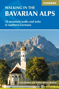
Walking in the Bavarian Alps: a complete planning guide
The Bavarian Alps stretch along Germany's southern border with Austria, from the Allgäu in the west to Berchtesgaden in the east — a 300km arc of mountain scenery that offers some of the most rewarding and accessible alpine walking in Europe. While these mountains cannot match the Matterhorn for height or the Eiger for drama, their particular charm lies in the combination of rugged peaks, forested valleys, flower-rich alpine meadows, and a culture of superb mountain huts that makes multi-day hut-to-hut trekking as comfortable as it is spectacular. Grant Bourne and Sabine Körner-Bourne's guidebook covers 70 graded walks and treks organised across six mountain groups, from half-day valley walks to three-day expeditions, with the Bavarian sections of two Via Alpina long-distance trails described as an additional option. (Last updated: June 2026 · Guidebook edition: 4th edition, 2023)
Walking in the Bavarian Alps, quick facts:
- Location: Bavarian Alps, southern Germany and the Austrian border, from the Allgäu to Berchtesgaden
- Total routes: 70 walks and treks (Walks 1–70)
- Distance range: 7.2km to approximately 400km (Via Alpina) per route
- Day walk duration range:2¾hrs to 10½–11hrs per walk
- Difficulty grades: Grade 1 (easy) to Grade 3 (experienced mountain walkers only)
- Terrain: Alpine meadows, mountain ridges, forested valleys, gorges, high passes, and glacier approaches; some routes involve moderate scrambling
- Highest point: Walk 27 ascends the Zugspitze, Germany's highest peak at 2962m, with 2232m of ascent
- Mountain huts: Well-equipped DAV (German Alpine Club) and OeAV (Austrian Alpine Club) huts throughout; members receive up to 50% discount
- Navigation: Well waymarked throughout; Kompass 1:50,000 maps recommended; GPX files available to download
- Best season: June to September/October; valleys accessible from April; highest routes can carry snow until June
- Main bases: Oberstdorf (Allgäu), Füssen and Hohenschwangau (Ammergau), Garmisch-Partenkirchen and Mittenwald (Wetterstein), Lenggries and Tegernsee (Tegernsee mountains), Ruhpolding and Inzell (Chiemgau), Berchtesgaden and Bad Reichenhall (Berchtesgaden)
- Guidebook:Walking in the Bavarian Alps by Grant Bourne and Sabine Körner-Bourne, 4th edition
Walking in the Bavarian Alps
70 mountain walks and treks in southern Germany
£18.95
Guidebook to mountain walks and treks in the Bavarian Alps, on the border of Germany and Austria, between Lake Constance and Berchtesgaden. Accessible from Munich, Salzburg and Innsbruck, these 70 routes range from half-day walks to 3-day hut-to-hut treks. Highlights include the Konigssee and Breitach, Partnach and Hollental gorges.
More information
What is Walking in the Bavarian Alps?
Walking in the Bavarian Alps by Grant Bourne and Sabine Körner-Bourne is a comprehensive mountain walking guide covering Germany's most popular alpine region. The 70 routes are organised across six mountain groups working west to east — the Allgäu, Ammergau, Wetterstein, Tegernsee, Chiemgau, and Berchtesgaden Alps — each with its own character, base towns, and range of walking.
The Bavarian Alps sit between the lowlands of Munich and the higher, wilder alpine ranges of Austria and Switzerland to the south. This position gives them a distinctive character: nowhere is it far from the valley bottom to the top of a rugged mountain peak, and a strenuous mountain day can be followed the next morning by a visit to Salzburg, a castle above Füssen, or a swim in one of the beautiful foothills lakes. The mountain hut network is extensive and well equipped, making hut-to-hut trekking both comfortable and logistically straightforward.
The guidebook also describes the Bavarian sections of two long-distance Via Alpina routes: the Purple Trail (Walk 69, approximately 400km, 26–28 days) and the shorter Red Trail (Walk 70, approximately 120km, 7 days), for walkers seeking a more extended alpine adventure. For complete route descriptions for all 70 walks, see the Cicerone Walking in the Bavarian Alps guidebook.
The 70 walks at a glance
The guidebook divides the Bavarian Alps into six mountain groups, each described with a base town portrait to help walkers choose where to stay. The table below covers the 68 day walks; the two Via Alpina multi-day routes are listed separately.
| Mountain groups | Walks | Distance range | Time range |
|---|---|---|---|
| I The Allgäu Alps | 1–14 | 9–20.5km | 3½hrs–1½ days |
| II The Ammergau Alps | 15–21 | 7.5–16.6km | 3¼hrs–6hrs |
| III The Wetterstein, Ester and Walchensee Mountains | 22–34 | 7.2–20.8km | 2¾hrs–10½hrs |
| IV The Tegernsee and Schliersee Mountains | 35–46 | 9–22km | 4hrs–8–9hrs |
| V The Chiemgau Alps | 47–55 | 9.8–27km | 3½hrs–3 days |
| VI The Berchtesgaden Alps | 56–68 | 7–36km | 2¾hrs–3 days |
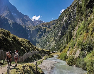
Part I: The Allgäu Alps (Walks 1–14) is the westernmost section, based primarily around Oberstdorf — a car-free town with one of the best bus networks in the Bavarian Alps. Fourteen walks explore the Nagelfluhkette ridge, the Großer Widderstein, the remote Oytal valley, and the Tannheimer Höhenweg. Walk 6 (Prinz-Luitpold-Haus to Landsberger Hut/Tannheim, 12km, 1½ days) is the section's hut-to-hut highlight.
Part II: The Ammergau Alps (Walks 15–21) covers the area around Füssen, Hohenschwangau, and Oberammergau — Bavaria's most famous cultural landscape, with Ludwig II's fairy-tale castles Neuschwanstein and Linderhof nearby. Seven walks range from easy valley routes to the challenging Grade 3 ascent over the Laberjoch to Ettal (Walk 18, 10km, 872m ascent).
Part III: The Wetterstein, Ester and Walchensee Mountains (Walks 22–34) is the most varied section, based primarily around Garmisch-Partenkirchen and Mittenwald. It includes Germany's highest peak, the Zugspitze (Walk 27, 20.7km, 2232m ascent, Grade 2–3, 10½–11hrs) and the spectacular Höllentalklamm gorge (Walk 28). Valley walks from Garmisch-Partenkirchen and Mittenwald provide easier options.
Part IV: The Tegernsee and Schliersee Mountains (Walks 35–46) covers the popular lakes country between Munich and the high Alps. Twelve walks include the long Blauberge traverse (Walk 40, 22km, 1026m ascent, Grade 2–3, 8–9hrs), the accessible Wendelstein (Walk 42, Grade 2), and several circuits in the forested hills above Tegernsee.
Part V: The Chiemgau Alps (Walks 47–55) covers the quieter eastern range above the Chiemsee, with the Kampenwand to Geigelstein traverse (Walk 47, 27km, 1840m ascent, Grade 2–3, 3 days) as the headline route and a good range of moderate mountain days including the Hochfelln (Walk 52, Grade 1–2) and the Rauschberg (Walk 53, Grade 1).
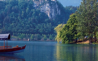
Part VI: The Berchtesgaden Alps (Walks 56–68) is the most dramatic section, covering the National Park area around Königssee, Ramsau, and Berchtesgaden. Highlights include the three-day hike through Berchtesgaden National Park (Walk 68, 36km, 1900m ascent, Grade 2–3), the Watzmann Haus approach (Walk 61), the Kehlstein Eagle's Nest (Walk 65), and the boat journey on the Königssee.

Who is Walking in the Bavarian Alps suitable for?
Walking in the Bavarian Alps covers an unusually wide range of abilities within a single guidebook. Grade 1 walks — including the Tannheimer Höhenweg section (Walk 14, Grade 1, 3½hrs), the Gerstruben valley (Walk 7, Grade 1, 4hrs), the Wimbachklamm gorge walk (Walk 60, Grade 1, 5½hrs), and the Kehlstein Eagle's Nest (Walk 65, Grade 1, 2¾hrs) — are suitable for any reasonably fit walker with no mountain experience.
Grade 2 routes, the majority of the guidebook, require a reasonable level of fitness, some experience of mountain terrain, and sure-footedness on exposed sections. Grade 3 routes — including the Zugspitze (Walk 27), the ascent over the Laberjoch (Walk 18), and several routes in the Chiemgau and Berchtesgaden sections — are suitable only for experienced mountain walkers with a head for heights and comfort on difficult terrain.
The guidebook is particularly well suited to walkers planning a week or more in one of the main base towns, combining day walks with hut nights and cultural excursions. Garmisch-Partenkirchen is the best all-round base for variety of terrain; Oberstdorf is the best base for those preferring to travel without a car.
Mountain huts in the Bavarian Alps
The hut network is one of the great advantages of walking in the Bavarian Alps. DAV (German Alpine Club) and OeAV (Austrian Alpine Club) huts are found throughout the region and are open to all, with members of either club entitled to discounts of up to 50% on accommodation. At lower-category huts (Category I) accommodation is in Matrazenlager (large dormitory with mattresses), while higher-category huts may offer smaller bunkrooms (Betten) or even double rooms.
All AV huts require a cloth sleeping bag liner (Hüttenschlafsack) and hut slippers (Hüttenschuhe), as boots are not permitted in sleeping areas. Most huts serve simple meals and snacks; members can also claim Teewasser (hot water for tea or coffee at a reduced price) and the cheaper Bergsteigeressen (mountaineer's meal). Cash is generally required as credit cards are rarely accepted.
Near the start or end of the walking season (June and late October), it is advisable to call ahead to check whether huts are open. Contact details for all huts mentioned in the route descriptions are given in Appendix C.
Members of the UK's Austrian Alpine Club (aacuk.org.uk) are entitled to the same privileges as DAV and OeAV members at huts throughout the Austrian and German Alps.
How difficult are the walks?
The guidebook uses a three-grade system. Grade 1 routes are clearly waymarked, involve no dangerous passages, and are suitable for anyone reasonably fit. Grade 2 routes are clearly waymarked but either longer or crossing more difficult terrain; some shorter exposed sections requiring greater care; a higher standard of fitness and sure-footedness is needed. Grade 3 routes are suitable only for those with sufficient experience in high alpine regions; terrain is often more difficult with longer exposed passages, and a good head for heights is essential.
Walking times are approximate and do not include refreshment stops. The guidebook recommends adding 5–10 minutes per hour walked for pauses, plus at least an hour for lunch and unforeseen circumstances. In autumn, building in extra buffer time before dark is strongly advised.
The most demanding single-day walk in the book is Walk 27 (the Zugspitze, 20.7km, 2232m ascent, Grade 2–3, up to 11hrs). The longest multi-day route is Walk 47 (Kampenwand to Geigelstein, 27km, Grade 2–3, 3 days).

When is the best time to walk in the Bavarian Alps?
The walking season runs from April to October, though conditions vary significantly by altitude and season.
- April to May: Valley walks and lower routes accessible; higher peaks and passes still likely to carry snow. A good time for quieter paths and spring wildflowers in the valleys.
- June to August: The main walking season. By June most routes above 1500m are clear of snow. July and August bring the most reliable weather but also the largest crowds on popular routes; afternoon thunderstorms are common. The Zugspitze and other high routes are most accessible in this period.
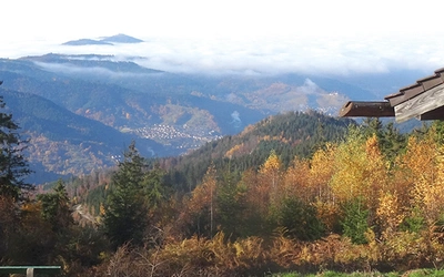
- September: Often the best month. Cooler, more stable weather, fewer people, spectacular autumn colours in the larch and beech forests, and the Föhn wind bringing crystal-clear visibility from the summits.
- October: Still pleasant on many routes, but shorter days and the risk of early snowfall at higher altitudes must be taken into account. Most cable cars and lifts stop operating by mid-October.
The climate is characterised by relatively high rainfall (up to 1500mm in the valleys, 2500mm in the mountains), so waterproof gear is essential at any time of year. The Föhn — a warm, dry wind from the south — brings exceptional visibility when it arrives, particularly in autumn.
Getting to the Bavarian Alps
By air: Munich International Airport is the main gateway, with onward connections by train, bus, or car to all base towns. Salzburg and Innsbruck airports are useful for the eastern part of the region (Berchtesgaden, Chiemgau). Frankfurt International Airport is the main hub for international travellers, with a railway station at the airport.
By rail: Eurostar from London to Brussels, then German ICE high-speed trains, connects to Munich in around 10 hours. From Munich, all base towns can be reached by regional train or bus. Oberstdorf, Garmisch-Partenkirchen, Mittenwald, and Berchtesgaden all have direct rail links from Munich.
By road: From Frankfurt, the A3, A7, and A8 motorways via Munich give quick access to the western, central, and eastern Bavarian Alps. The region is approximately 969km from Dunkirk; Garmisch-Partenkirchen is 90km from Munich.
Getting around: All base towns can be reached by train or bus, and transport details to the start of each route are given at the start of each walk description. The bus network in Oberstdorf is particularly well organised. Visitors staying at any of the Kurorte (spa resorts) receive a Gästekarte (visitor's card) which usually entitles them to free or discounted travel on local and regional buses.
What are the highlights of walking in the Bavarian Alps?
- The Zugspitze (Walk 27, Grade 2–3) is Germany's highest peak at 2962m, reached on a demanding full-day ascent from Garmisch-Partenkirchen with 2232m of climbing. The summit view across the Alps on a clear day is exceptional.
- Königssee and the Berchtesgaden National Park (Walks 66–68) is the most dramatic scenery in the guidebook: the electric-blue lake, the sound of the guide's trumpet echoing off the sheer rock walls, and the Watzmann massif looming above the valley.
- The Höllentalklamm gorge (Walk 28) is one of Bavaria's most spectacular natural features, a narrow defile cut by the Hammersbach stream through the limestone of the Wetterstein, with ladders and fixed ropes along the path.
- Neuschwanstein and Linderhof (Walks 16 and 20) are Ludwig II's fairy-tale castles above Hohenschwangau and in the Ammergau hills, both visible or accessible on routes in Part II — walking context for one of Bavaria's most famous cultural attractions.
- The Chiemgau traverse (Walk 47, Kampenwand to Geigelstein, 3 days) is the finest extended route in the book, a three-day traverse through the lesser-known eastern Alps with exceptional wildflower meadows and excellent hut accommodation.
- The Kehlstein Eagle's Nest (Walk 65, Grade 1, 2¾hrs) is the most historically significant walk in the guidebook, ascending to a restaurant and museum with extraordinary views over the Berchtesgaden valley.
- Oberstdorf and the Allgäu is the best base for those travelling without a car, with the finest bus network in the Bavarian Alps and a dozen varied walks within reach — from the easy Gerstruben valley (Walk 7) to the demanding Rubihorn ridge (Walk 4, Grade 3).
Plan your walk with the Cicerone guidebook
The Cicerone Walking in the Bavarian Alps guidebook by Grant Bourne and Sabine Körner-Bourne contains everything you need to plan and complete all 70 walks across the region.
- 70 graded walks and treks organised across six mountain groups, from half-day valley walks to three-day hut-to-hut treks
- Route summary table (Appendix A) listing all 70 routes by walk, start, distance, ascent, descent, grade, and time
- Base town portraits for each mountain group, helping walkers choose where to stay and providing local practical information
- Mountain hut listings (Appendix C) with contact details for all huts mentioned in route descriptions
- Bavarian sections of the Via Alpina Purple Trail (Walk 69, approx 400km, 26–28 days) and Red Trail (Walk 70, approx 120km, 7 days)
- Free GPX files available to download at cicerone.co.uk/929/GPX
- Comprehensive introduction covering history, culture, plants and wildlife, getting there, accommodation, mountain huts, climate, clothing and equipment, safety, food and drink, and maps
- Useful contacts (Appendix D) and glossary (Appendix E) covering German and Bavarian mountain terminology
Available as a printed guidebook (£18.95) or digital eBook (£18.95).
Walking in the Bavarian Alps
70 mountain walks and treks in southern Germany
£18.95
Guidebook to mountain walks and treks in the Bavarian Alps, on the border of Germany and Austria, between Lake Constance and Berchtesgaden. Accessible from Munich, Salzburg and Innsbruck, these 70 routes range from half-day walks to 3-day hut-to-hut treks. Highlights include the Konigssee and Breitach, Partnach and Hollental gorges.
More informationAbout the authors:
Grant Bourne is a New Zealander whose fascination with other lands and cultures has taken him through much of Asia, Africa, the Near East, and Europe. He has written and illustrated numerous travel guides, with a main focus on Germany and New Zealand. His love of the outdoors has taken him along the tramping tracks of his native country and up Mt Kenya, through the hills of northern Thailand, and on the trekking trails of Nepal. Now living in the Rhine Valley, Germany, he keeps fit by walking the trails along the Rhine and on regular walking holidays in the Bavarian and Swiss Alps. Find Grant on Instagram at @grantsbavarianalps.
Sabine Körner-Bourne is a native of Germany and, like her husband Grant, a keen hiker. Together they have explored numerous trails in exotic parts of the world, though Sabine has never lost her affection for the many beautiful routes to be found in her home country.