Walking in the Forest of Bowland and Pendle: a complete planning guide
For generations, the word 'Lancashire' conjured smoky mill towns rather than wild moorland, and Terry Marsh's Walking in the Forest of Bowland and Pendle sets out to correct that picture. This planning guide draws on his 40 circular walks across the Forest of Bowland National Landscape and the Pendle Hill countryside, ranging from 5 to 20km (3 to 13 miles), to help you choose routes, plan transport and pack the right gear for genuinely wild walking country. (Last updated: July 2026 · Guidebook edition: First edition, reprinted 2022)
Walking in the Forest of Bowland and Pendle, quick facts
- Location: Forest of Bowland National Landscape and the countryside around Pendle Hill, Lancashire, England
- Total routes: 40 circular day walks
- Distance range: 5–20km (3–13 miles)
- Typical duration: Half-day to full-day, depending on the route chosen
- Difficulty: Shorter, low-level walks up to longer, more strenuous hill routes; navigational skills required throughout
- Terrain: Open moorland, upland fells, blanket bog and river valleys (Lune, Hodder and Ribble), plus rural farmland
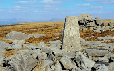
- Highest point: Ward's Stone, 561m
- Navigation: Route descriptions supported by 1:50,000 Ordnance Survey mapping (reproduced at 1:60,000); map and compass skills assumed
- Best season: Year-round, with clearer summit views in spring, summer and autumn
- Guidebook: Walking in the Forest of Bowland and Pendle, Terry Marsh, First edition (reprinted 2022)
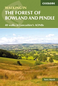
Walking in the Forest of Bowland and Pendle
40 walks in Lancashire's Area of Outstanding Natural Beauty
£11.95
A guidebook to 40 diverse circular day walks suitable for walkers with navigational skills. The Forest of Bowland and Pendle are two of north west England's upland AONBs, perfect for walkers who enjoy exploring rough hilly, sometimes pathless terrain. The routes include Ward's Stone, Pendle Hill, Longridge Fell and Fair Snape Fell.
More informationWhat is Walking in the Forest of Bowland and Pendle?
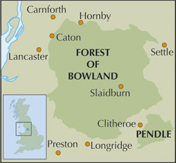
Walking in the Forest of Bowland and Pendle is Terry Marsh's guide to 40 circular day walks across two adjoining Lancashire landscapes: the Forest of Bowland, at 310 square miles (800 sq km) the larger of the county's two National Landscapes, and the separate but linked Pendle Hill countryside to the south. Between the two lies the Ribble Valley, centred on Clitheroe, and the book's coverage runs from north of the River Lune, across the Ribble Valley, and around Pendle Hill to the outskirts of Colne and Nelson.
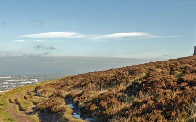
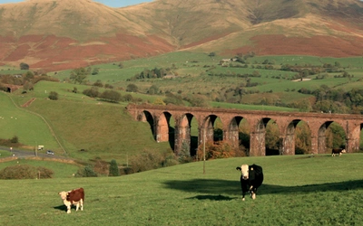
Marsh, a Lancashire-born writer, is candid that the county's reputation precedes it unfairly. As he puts it, most people picture "smoky grey blocks of heavy industry" rather than the "lakes and woods and rolling hills" the late comedian Les Dawson once described, and the terrain covered by this guidebook argues otherwise. It ranges from the lush farmland of the Ribble Valley, through the rougher pastures of the Bowland uplands, to the boggy heights of the main Bowland massif itself, a genuine contrast of walking styles within a single, compact guidebook.
For summit-collectors, the area contains six of the so-called 'Marilyns' (hills with at least 150m of prominence): Ward's Stone, Pendle Hill, Longridge Fell, Fair Snape Fell, White Hill and Easington Fell. Four of the six are reached directly by walks in the book, and White Hill can be added as a boggy extension to two of the routes.
This planning guide answers the most common questions walkers have before setting out. For complete stage-by-stage route descriptions and mapping, see the Cicerone Walking in the Forest of Bowland and Pendle guidebook.
How do the 40 routes divide?
The guidebook is organised into six geographic sections, moving roughly north to south and west to east across the National Landscape:
- Lune Valley (Walks 1–5): riverside and lower-fell routes around Caton, Crook o' Lune and Littledale, including the first ascent of Ward's Stone from the Lune side
- Northwest and Western Moors (Walks 6–14): the higher Bowland fells, including Clougha Pike, Ward's Stone from Tarnbrook, and Parlick and Fair Snape Fell
- Central Moors (Walks 15–17): remote moorland rounds through Langden, Brennand and Whitendale, and Croasdale
- Hodder Valley (Walks 18–25): Longridge Fell, the River Hodder around Whitewell and Dunsop Bridge, Stocks Reservoir and Bowland Knotts
- Ribble Valley (Walks 26–31): lower, gentler routes around Clitheroe, Hurst Green, Sawley and Bolton-by-Bowland, following stretches of the Ribble Way
- Pendle (Walks 32–40): routes around Pendle Hill itself, plus Sabden, Downham, Whalley and the outlying Weets Hill near Salterforth
Eight of the walks at a glance
| Walk | Area | Distance | Why it stands out |
|---|---|---|---|
| Ward's Stone from Littledale | Lune Valley | 17km (10½ miles) | Reaches the National Landscape's highest point (561m) from its quieter northern side |
| Clougha Pike | Northwest and Western Moors | 8km (5 miles) | Singled out in the guidebook's own overview as one of the area's best viewpoints |
| Parlick and Fair Snape Fell | Northwest and Western Moors | 8km (5 miles) | Takes in a second of the area's six Marilyn summits |
| Longridge Fell | Hodder Valley | 8km (5 miles) | A third Marilyn, and one of the few wooded ridge walks in the book |
| Stocks Reservoir | Hodder Valley | 13km (8 miles) | Circles one of the Bowland Fringe's main water bodies |
| Sawley and the Ribble | Ribble Valley | 8km (5 miles) | Passes Sawley Abbey, one of the "must-see" sites |
| Downham and Twiston | Pendle | 7km (4¼ miles) | Explores Downham, a historic village linked to the Pendle witch trials |
| Pendle Hill from Barley | Pendle | 7km (4½ miles) | Climbs the area's most famous summit (557m) by its best-known approach |
Who is Walking in the Forest of Bowland and Pendle suitable for?
The guidebook is aimed at competent, self-sufficient walkers rather than complete beginners. Marsh assumes readers "possess navigational skills, are conversant with map and compass technique, and know how to clothe and protect themselves effectively." Some walks cross bleak, featureless moorland where mist is a genuine hazard, and a handful involve short stretches of road walking, though these have been kept to a minimum.
That said, the range within the book is real: the shorter, lower-level routes in the Lune and Ribble Valleys suit less experienced walkers and families, while the central and western moorland rounds, and the Marilyn summits in particular, are better suited to confident hill walkers used to pathless, boggy terrain. In winter, snow and ice on the tops can make an ice axe a sensible addition, though Marsh is clear this is only useful to those who already know how to use one.
When is the best time to walk in the Forest of Bowland and Pendle?
- Spring and early summer: Ground conditions improve after winter, and the moorland breeding birds (hen harrier, merlin, golden plover, curlew) are at their most active, making this a rewarding season for birdwatchers as well as walkers
- Summer: The most reliable underfoot conditions on the peat and blanket bog sections; also the main season for dog walkers, since the right to walk dogs on Access Land (1 March to 31 July, and at other times near livestock) applies on a 2-metre lead
- Autumn: Good visibility and settled weather often persist into September and October, with fewer crowds than summer at Pendle Hill
- Winter: All walks remain technically feasible for competent parties, but exposed moorland sections such as Ward's Stone and the central Bowland fells can hold snow and ice, and mist turns featureless moor into a genuine navigation hazard
Can I walk with a dog in the Forest of Bowland and Pendle?
Partly, and it depends where. A significant part of the northwestern Bowland fells is managed for grouse and is a dog-exclusion zone throughout the year. Elsewhere, dogs may be temporarily excluded from land used for lambing, from enclosures under 15 hectares for up to six weeks a year, and from areas important for ground-nesting birds.
Outside these exclusions, access rights allow dog walking between 1 March and 31 July (and at other times near livestock or nesting birds), provided the dog is kept on a lead no longer than 2 metres. Where a specific walk in the guidebook falls within a dog-exclusion area, this is flagged in that walk's introductory information box.
What accommodation is available?
The guidebook is structured around day walks rather than multi-day itineraries, so most walkers will base themselves in one of the area's market towns and villages and drive or take public transport out to each walk's start point. Centres for the area include Caton, Dunsop Bridge, Slaidburn, Whalley, Clitheroe, Chipping, Sawley, Bolton-by-Bowland and Downham.
Getting there and back
Lancaster sits on the West Coast Main Line and gives access to walks in the Lune Valley and the northwestern moors. Clitheroe, at the southern end of the guidebook's coverage, is the terminus of the Ribble Valley line, with an hourly service to and from Manchester Victoria via Blackburn, and its station forms part of the Clitheroe Interchange bus station, with onward bus connections to Chipping, Dunsop Bridge, Sawley and Whalley. Slaidburn and the more remote Hodder and Central Moors starting points are best reached by car or local bus service from Clitheroe, since they have no rail link of their own.
What are the route highlights?
- Clougha Pike and Ward's Stone, the two highest points in the Forest of Bowland, both reached directly by walks in the book
- Sawley Abbey, on the banks of the Ribble, passed on the Sawley and the Ribble walk
- Pendle Hill, at 557m the area's most recognisable summit and the focus of two separate walks
- Downham, Hurst Green and Waddington, three of the guidebook's "must-see" historic villages
- Stocks Reservoir, one of the main water bodies of the Bowland Fringe landscape
Walking in the Forest of Bowland and Pendle
40 walks in Lancashire's Area of Outstanding Natural Beauty
£11.95
A guidebook to 40 diverse circular day walks suitable for walkers with navigational skills. The Forest of Bowland and Pendle are two of north west England's upland AONBs, perfect for walkers who enjoy exploring rough hilly, sometimes pathless terrain. The routes include Ward's Stone, Pendle Hill, Longridge Fell and Fair Snape Fell.
More informationPlan your Forest of Bowland and Pendle walks with the Cicerone guidebook
The Walking in the Forest of Bowland and Pendle guidebook by Terry Marsh contains everything you need to plan and complete all 40 walks, from the Lune Valley in the north to Pendle Hill in the south.
- Full route descriptions for all 40 circular walks, organised into six geographic sections
1:50,000 Ordnance Survey mapping (reproduced at 1:60,000) accompanying every walk - A route summary table in the appendix for comparing distance, height gain and difficulty across the book
- Start/finish information boxes for each walk, including refreshment and toilet facilities, terrain notes and relevant OS map references
- Background chapters on the history of Lancashire and the landscape of the Forest of Bowland and Pendle AONB
- Practical notes on access, dog restrictions and navigation across the area
- Free online route updates
Available as a printed guidebook (£11.95) or digital eBook.
About Terry Marsh, guidebook author
Lancashire-born writer and photographer Dr Terry Marsh specialises in the outdoors and travel. He has been writing guidebooks since the mid 1980s and is the author or revision author/editor of over 100 titles, including the award-winning Cicerone guides to the Coast-to-Coast Path (first published in 1993), The Shropshire Way (1999) and Great Mountain Days in the Pennines (2013).
Terry has a long-standing interest in the Scottish islands, Cumbria and the Lake District and the Yorkshire Dales. Academically, he is an historical geographer holding a Master of Arts degree with Distinction in Lake District Studies and a PhD in Historical Geography. He is a Life Member of the Outdoor Writers and Photographers Guild.