Walking in the Lune Valley and Howgills: a complete planning guide
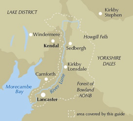
Set between the Lake District and the Yorkshire Dales, the Lune Valley "begs discovery," and this planning guide will help you find the right walk among the 40 circular day walks ranging from 3 to 11 miles (5 to 18km) in Dennis and Jan Kelsall's Cicerone guidebook. Routes clamber onto the Howgill Fells, delve into tributary dales like Dentdale and Borrowdale, and follow the River Lune itself down to Morecambe Bay. (Last updated: July 2026 · Guidebook edition: 2nd edition, November 2021)
Walking in the Lune Valley and Howgills, quick facts
- Location: the Lune Valley, between the Lake District National Park and the Yorkshire Dales National Park, taking in the Forest of Bowland and Arnside and Silverdale National Landscapes
- Total routes: 40 circular day walks
- Distance range: 3–11 miles (5–18km)
- Typical duration: 1–6 hours
- Difficulty: Easy to moderate, suitable for walkers of all abilities
- Terrain: riverside paths, rolling fells, open moorland, historic farmland and villages, tidal estuary and coast
- Highest point: The Calf, 672m, the summit of the Howgill Fells
- Navigation: step-by-step route directions with 1:50,000 OS mapping and downloadable GPX files
- Best season: spring to autumn, though the Howgills and Bowland fringe demand care in winter
- Guidebook: The Lune Valley and Howgills, Dennis and Jan Kelsall, 2nd edition (November 2021)
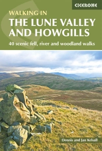
The Lune Valley and Howgills
40 scenic fell, river and woodland walks
£12.95
Guidebook to 40 walks, from 3 to 11 miles, exploring the Lune Valley and Howgill Fells, some of the most unspoilt countryside in north west England. Set mainly within the Yorkshire Dales National Park, and the AONBs of Bowland and Arnside and Silverdale, the walking is hugely rewarding, near the centres of Sedbergh, Kendal and Lancaster.
More informationWhat is Walking in the Lune Valley and Howgills?
Walking in the Lune Valley and Howgills is a Cicerone guidebook collecting 40 circular day walks across the valley of the River Lune, from its Howgill Fells headwaters near Kirkby Stephen down through Sedbergh, Kirkby Lonsdale and Lancaster to the tidal marshes of Morecambe Bay. The routes climb onto the hills overlooking the main valley, wander into tributary dales such as Dentdale and Borrowdale, and trace the Lune itself as it changes character from moorland stream to estuary.
The book covers a landscape that lacks the single-identity branding of a national park but overlaps three protected areas: the Yorkshire Dales National Park, the Lake District National Park, and the Forest of Bowland National Landscape, alongside the Arnside and Silverdale National Landscape near the coast. At its heart stand the Howgill Fells, a distinctive, unfenced massif rising to 672m at The Calf, cut off from its neighbours by the Lune Gorge and the Dent Fault.
Unlike better-known walking areas nearby, the guidebook's authors are candid that "there are no 'highest peaks' to climb or 'longest ridges' to traverse" in and around the Lune, and present the valley instead as a place of quiet, unfrequented hills and villages, rewarding for exactly that obscurity. This planning guide answers the most common questions walkers have before setting out. For complete route descriptions and mapping, see the Cicerone Lune Valley and Howgills guidebook.
How does the guidebook divide the Lune Valley?
The 40 walks are arranged geographically, starting in the north of the region and following the river southwards to the sea. They fall into five broad groupings:
- The upper Lune and Howgill Fells (Walks 1–15): from Weasdale and Newbiggin-on-Lune, traditionally reckoned near the river's source, through Orton and Bretherdale to the high Howgill tops, including Bowderdale and The Calf and the gorge scenery of Carlin Gill
- Sedbergh and Dentdale (Walks 16–21): routes based around Sedbergh and the River Rawthey, into Dentdale and Garsdale, and over Calf Top and Frostrow Fells
- Kirkby Lonsdale and the middle Lune (Walks 22–27): Casterton, Kirkby Lonsdale itself, and the river as it winds past Leck Beck and Melling
- The lower tributary valleys (Walks 28–31): Roeburndale, Littledale and Clougha Pike, on the northern fringe of the Forest of Bowland
- Lancaster and the estuary (Walks 32–40): riverside and canal walks around Lancaster, out to Glasson Dock, Cockersand Abbey and the coastal points of Overton and Sunderland Point
| Walk | Distance (miles/km) | Time (hr) | Why it stands out |
|---|---|---|---|
| Bowderdale and The Calf | 11/17.7 | 5½ | Climbs The Calf, at 672m the highest summit in the book and the highpoint of the unfenced Howgill Fells, via broad grassy ridges radiating from the top |
| Whinfell and Borrowdale | 9/14.5 | 4¾ | Explores Borrowdale, singled out in the guidebook introduction as a "little-known delight," combined with a traverse across Whinfell Common |
| Carlin Gill | 3¼/5.2 | 1½ | Follows a twisting gorge the guidebook introduction calls "one of the Howgills' particular gems," cut alongside the Lune Gorge fault line |
| Sedbergh and the River Rawthey | 5/8 | 2¼ | Takes in Sedbergh, one of only two towns sited directly on the Lune's catchment, an ancient market centre set back from the main valley |
| Kirkby Lonsdale | 6½/10.5 | 3 | Reaches Ruskin's View, the prospect over the Lune painted by JMW Turner and later championed by John Ruskin, at the valley's other historic market town |
| Clougha Pike | 5½/8.8 | 2¾ | Climbs one of the Forest of Bowland's "satisfying heights," among England's least-frequented hills, on the southern fringe of the Lune catchment |
| Halton, the Crook o'Lune and Gray's Seat | 4/6.4 | 1¾ | Passes the Crook o'Lune, another Turner subject, and one of the river's most reliable spots for otter sightings |
| Cockersand Abbey | 7/11.3 | 3 | Visits the remains of a Premonstratensian abbey on the open coast, the only one of the valley's three medieval religious houses sited by the sea |
Who is Walking in the Lune Valley and Howgills suitable for?
The guidebook is aimed at walkers of all abilities, and the majority of its 40 routes are lowland walks that present no particular difficulty. Families, dog walkers and less experienced walkers are well catered for among the riverside, valley and canal-side routes, particularly those around Kirkby Lonsdale, Sedbergh and Lancaster.
A smaller number of routes venture onto the higher moors and hills of the Howgill Fells and the Bowland fringe, and here competent navigation skills and reasonable stamina become necessary, especially in winter conditions. None of the 40 walks demands scrambling or climbing ability, though some involve brief steep sections.
How difficult are the walks?
Difficulty across the collection ranges from easy to moderate. The lowland and valley routes are generally straightforward and well waymarked. On the open tops of the Howgills, the absence of fencing or walls, combined with a scarcity of unambiguous landmarks, means navigation can be genuinely challenging in cloud, and the guidebook flags competent compass use as a requirement on these sections. Good waterproof footwear and windproof, waterproof clothing are treated as basic equipment throughout, and none of the routes should be attempted underequipped in poor forecast conditions.
When is the best time to walk in the Lune Valley?
- Spring and early summer: the woodlands, meadows and hedgerows are at their most colourful, generally alongside the best weather of the year
- Late summer: the moors come into their own as the heather flowers
- Autumn: turning leaves bring rich colour to the valley, and it is also the best season for fungi
- Winter: crisp days can open up long-distance views from the tops, but conditions on the Howgills and Bowland fells can turn challenging quickly, even for experienced walkers
There is no single best shoulder season beyond the general recommendation to favour spring through autumn for the higher routes, reserving winter for the valley and lowland walks.
What accommodation is available?
Hotels, bed and breakfast and self-catering cottages are available at the main centres of Lancaster, Kirkby Lonsdale and Sedbergh, as well as in many of the surrounding villages, with a good selection of camping and caravan sites throughout the valley. Tebay and Dent also serve as useful bases for the upper valley and Dentdale respectively.
Some smaller hamlets along the Lune have lost their shops and pubs entirely, so it is worth basing a multi-day visit around one of the main centres and driving or walking out to the more remote routes, rather than relying on facilities en route. The guidebook's Appendix C lists accommodation contacts and websites in full.
How do I get to the Lune Valley?
The valley is readily accessible from the M6 motorway, and Lancaster, Oxenholme (on the eastern edge of Kendal) and Penrith stations all sit on the West Coast Main Line. Local bus services reach some villages, though rural timetables do not always suit walkers' needs, and checking Traveline in advance is recommended. Anyone driving should be aware that the valley's lanes are narrow and winding, shared with slow-moving farm traffic, pedestrians, horse riders and cyclists.
What wildlife might I see while walking in the Lune Valley?
With little industry or heavy habitation along its course, the River Lune is one of England's cleanest rivers and correspondingly rich in wildlife. It is an important salmon river, with sea and river trout also present, and rare colonies of white-clawed crayfish and pearl mussels survive in places, supported by ongoing conservation projects.
Otters have holts along the river from Halton up to Tebay, with the Crook o'Lune a favoured spot for sightings, while roe deer, badger, fox and hare are widespread across the surrounding countryside. Britain's native red squirrel survives precariously near the top of the valley around Newbiggin. Birdlife is abundant throughout: herons, oystercatchers and kingfishers along the river, dippers and wagtails in the wooded side-valleys, and merlin and hen harrier on the Bowland moors, the latter adopted as the emblem of the Forest of Bowland National Landscape. The estuary at the valley's foot draws flocks of waders, geese and swans according to the tide.
The Lune Valley and Howgills
40 scenic fell, river and woodland walks
£12.95
Guidebook to 40 walks, from 3 to 11 miles, exploring the Lune Valley and Howgill Fells, some of the most unspoilt countryside in north west England. Set mainly within the Yorkshire Dales National Park, and the AONBs of Bowland and Arnside and Silverdale, the walking is hugely rewarding, near the centres of Sedbergh, Kendal and Lancaster.
More informationPlan your Lune Valley and Howgills walks with the Cicerone guidebook
The Lune Valley and Howgills by Dennis and Jan Kelsall contains everything you need to plan and complete 40 day walks across the valley, from the Howgill Fells' upper reaches near Kirkby Stephen to the tidal marshes at Morecambe Bay.
- 40 circular day walks from 3 to 11 miles (5–18km), suitable for walkers of all abilities
- Step-by-step route descriptions with 1:50,000 OS mapping
- Practical information on transport, accommodation, wildlife and geology
- Free guidebook updates on the Cicerone website
Available as a printed guidebook (£12.95) and digital eBook.
About Dennis and Jan Kelsall, guidebook authors
Both native Lancastrians, Dennis and Jan Kelsall have long held a passion for countryside and hill walking. Since their first Cicerone title was published in 1995, they have written and illustrated around 35 guides covering some of Britain's most popular walking areas and have become regular contributors to various outdoor magazines. Their enjoyment of the countryside extends far beyond a love of fresh air, the freedom of open spaces and an appreciation of scenery. Over the years Dennis and Jan have developed a wider interest in the environment, its geology and wildlife, as well as an enthusiasm for delving into the local history that so often provides clues to interpreting the landscape.