Climbing Aconcagua: the world's highest trekking peak
After ticking off Kilimanjaro and Elbrus, Peter Watson headed to the Andes to attempt his third Seven Summit. Aconcagua may not require mountaineering skills, but this hulk of rock proved to be no walk in the park.
People do not climb Aconcagua for its beauty. It is not a picturesque mountain by any stretch of the imagination. Mountaineers and writers will never wax lyrical about Aconcagua’s pyramidal symmetry or its needlepoint summit. It’s just not that sort of mountain.
Instead, Aconcagua is a dark, foreboding, unwieldy mass of Andean volcanic rock amid an equally bleak landscape. But what the mountain lacks in elegance, it makes up for in notoriety – for the accolades on offer are legion.
At 6962m, Aconcagua is the highest mountain in the Americas; the highest mountain in the Western Hemisphere; the Southern Hemisphere and outside Asia.
Finally, as the climb does not require any mountaineering experience, Aconcagua carries the badge of honour of the highest trekking peak in the world. Technical climbing skills are not required on its slopes. Instead, aerobic endurance, stamina and overall fitness and strength are the prerequisites for summit success. An ascent of Aconcagua may not require an ice axe, ropework or crampons, but it’s not a task to be taken lightly, either.
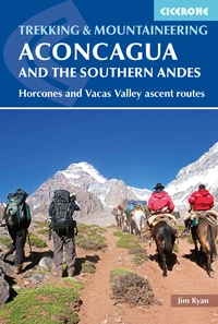
Aconcagua and the Southern Andes
Horcones Valley (Normal) and Vacas Valley (Polish Glacier) ascent routes
£16.95
Guidebook to climbing Aconcagua in Argentina. With descriptions for the Normal route (taking 12 days) or the Vacas Valley route (14 days). The treks cover difficult mountain terrain up to 6962m and are suitable for experienced walkers and mountaineers. Also features other treks in the southern Andes, including the Vallecitos and Tupungato ranges.
More informationThe Seven Summits
Aconcagua is a member of the Seven Summits, the highest peaks on each continent. It is the second-highest of the seven after Asia’s Mount Everest. In their quest to conquer all seven, climbers travel from all over the world to reach Aconcagua’s summit. Like me, they don’t come for the scenery, but the glory.
I climbed Kilimanjaro in Tanzania back in 2010. Climbing Africa’s highest peak gave me the idea of climbing all Seven Summits. It took me several years to get around to Elbrus, the highest peak in Europe, and then I also ticked off Kosciuszko, the highest mountain in Australia. However, I don’t include Kosciuszko as I subscribe to the Messner List, which means Kosciuszko is not a Seven Summit. Instead, Puncak Jaya in Indonesia, the highest mountain on the wider Australian continent (Oceania), represents that corner of the world.
Anyway, I digress. In January 2020 I found myself on the slopes of Aconcagua because it was the next step towards realising my ultimate dream of climbing the Seven Summits.

The trek in
There are several routes up Aconcagua, but the vast majority of climbers take either the ‘Normal Route’ also known as the Horcones Valley, or the Vacas Valley Route, more commonly known as the Polish Glacier Route. I climbed via the ‘Normal Route’, so my trek began at the Horcones Ranger Station at the entrance of Parque Provincial Aconcagua some three hours and 170km west of Mendoza. I was climbing as part of an international team of 12 climbers.
The initial march in is the most beautiful part of the climb. The trails are discernible and solid underfoot and the route winds its way through the only greenery of the climb. The first day is a short three-hour hike to Confluencia Camp located at around 3400m. The organised campsite has many luxuries such as running water and flushing toilets and enjoys a picturesque setting with the south face of Aconcagua in sight.

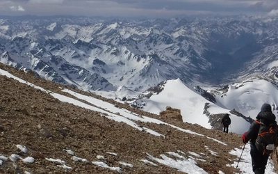
The following day was our first acclimatisation hike. We hiked to the rocky plateau of Plaza Francia at around 4000m, where we got our most scenic view of Aconcagua. Alas, this is the south face and not the route that we would ascend. It’s a blessing in disguise as although this route would be more spectacular, the south faces of mountains in the Southern Hemisphere are more exposed, unlike in the Northern Hemisphere where it’s the opposite.

En route, we got our first taste of the infamous Aconcagua breeze. The wind around these parts is ferocious and rarely moderate. The wind chill factor on Aconcagua can be extreme, lowering temperatures by as much as 15°C (59°F).
The following day we moved up to base camp, known as Plaza de Mulas as it’s the final stop for the herds of mules that transport equipment and supplies for clients. The hike is a long traipse up the Horcones Valley following the Horcones River – or its remnants depending on the time of year – with the Andean wind whipping up dust throughout.
By mid-afternoon, the ground steepens dramatically before the sea of tents that is base camp – at 4300m – finally comes into view.
Acclimatisation continues
A much-needed rest day at base camp ensued before we made our second acclimatisation hike of the expedition. The nearby Cerro Bonete, at just over 5000m, takes around four hours to ascend and 2.5 hours to descend.

The hike provided some of the best views of the climb, particularly when at the summit. From the summit of Bonete it was possible to see the mountains of the Chilean Andes to the west and Aconcagua to the east. When standing on the summit at 5000m it was rather daunting to look at Aconcagua, still towering nearly 2km above.
The following day was our first load carry up the mountain, which doubled as another acclimatisation hike. Above base camp, we would each be responsible for transporting our own gear and supplies so we carried around 15kg each up to the site of Camp 1, also known as Camp Canadá.
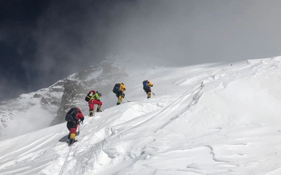
We got our first experience of the morale-sapping switchbacks that slowly lead climbers up the mountain. The terrain is dusty and arid so it must be walked at a snail’s pace. After five hours of plodding, we were happy to cache our loads at Canadá and then careen back down to base camp in a third of the time to enjoy our final day of rest before moving up the mountain for real.

Higher camps
The second carry to Camp 1 was much like the first, except this time we were there to stay. Camp 1 sits behind a rocky outcrop just below 5000m and boasts excellent views of the valley and glacier. Life above base camp is quieter, simpler and more routine. Between climbs, our time largely revolved around eating, collecting ice for melting, drinking said meltwater and taking numerous trips to the toilet tent.
The next stop would be Camp 2 or Nido de Cóndores (Nest of the Condores) at around 5560m. All our gear now had to be moved up in one carry of around 25kg. To call the day punishing would be an understatement. The wind was strong, the slope steep and the sandy terrain utterly demoralising.
A miserable and exhausted bunch of climbers traipsed into Camp 2 that afternoon. The only solace was that the following day would be a rest day – our final one of the expedition.
Our final move was up to Camp 3, also known as Cólera Camp, at around 6000m. Our packs were slightly lighter as we had stashed a lot of gear at Camp 2 that we wouldn’t need above. However, much of the weight had been replaced by seven litres of water we had to carry to Camp 3. Reports had come down that there wasn’t enough snow above so we had to transport water for cooking our meals and drinking on summit day.
Much like the previous climb to Camp 2, this was a merciless affair. This was now higher than I’d ever been before and the effects of altitude were really beginning to set in. Breathing was noticeably harder so more rests were required, which made our progress even slower. After a cruel scramble over a shelf of rock jutting out below camp, we stumbled into our final campsite of the climb.
The rest of the day was spent pitching our tents and trying to drink, eat and sleep as much as we could before the final chapter of our climb.
Summit day
I – like most climbers – have a love-hate relationship with summit days. There’s nothing quite like standing on top of a mountain. Likewise, there’s nothing quite like getting up at 3am on the side of said mountain either. The middle of night at 6000m is pretty much how one might expect it to be: dark, windy and bitterly cold.
The initial climb out of camp was steep but we made good time despite some fairly miserable weather. There was a thick fog enveloping us constantly and the wind was relentlessly intense. By the time it got light we had made it to an old ruined hut known as Independencia at around 6400m, where we paused for gulps of hot tea.
Next up was the Cresta del Viento traverse, an exposed steady climb around the mountain leading to the infamous Canaleta. The Canaleta is an exasperating passage of slippery scree. The loose terrain essentially means for every two steps forward you slide back one. It’s 400m high and takes several soul-destroying hours to ascend.
The final chance to rest comes at La Cueva (The Cave), a semi-sheltered cliff where climbers stop briefly before tackling the final clamber to the summit. By now, our team had diminished to just seven – five members had been forced to turn back due to exhaustion.
A mass of large boulders presents the final obstacle to overcome just below the summit. Here, I was able draw on some final reserves of energy to clamber onto the summit plateau. It was a white out. The Cicerone guide tells me that on a clear day the 'views from the summit are stunning', but unfortunately I will have to take the author’s word for it.

I lumbered over to the simple aluminium crucifix that marks the apex of the Americas and spluttered a sigh of relief before collapsing nearby to drink some tea.
The morning had been torture. There had been no love in this particular summit day relationship, but I stood upon the highest point in South America, my third mountain of the Seven Summits and I had achieved what I‘d set out to.
Celebrations were short-lived. It was savagely cold up there and it was time to get down. Summit shots snapped, we began our descent returning the way we’d ascended and four hours later we shuffled back into Camp 3 and dived into our tents.
48 hours after that we were back in Mendoza after charging down to base camp and then marching out the same route we’d come in two weeks earlier.
Back in Mendoza my exploits felt like a dream. Unlike every mountain I’d previously climbed, Aconcagua was never about the love of climbing. It was the next hurdle to overcome towards realising my ultimate ambition of climbing the Seven Summits. Life on its slopes had been rough and at times even distressing. It had proved to be the hardest ascent of my life.
Aconcagua had been on my bucket list for nearly 10 years, and had taken months of planning, preparation and training, but was now, finally over. Three down, four to go. Next step, Denali...
Aconcagua at a glance
- 6962m (22,841ft) high
- 15–18 days
- 2 trekking routes
- 100-120km (62–75 miles)
- 5 campsites
- 12 to 15-hour summit day
- Cost: $5000-$7000
- Access via Mendoza with flights usually connecting in either Buenos Aires or Santiago in Chile
- Best time to climb: mid-November through March
- Visas are usually not required for stays of up to 90 days