Into the Gondwana Rainforest: Walks in Lamington National Park on Australia’s Gold Coast

Mike Dunn explores Lamington National Park on Australia’s Gold Coast, an astonishingly biodiverse area of mountains and deeply dissected valleys and a key element of the Gondwana rainforests World Heritage Site.
Australia’s Gold Coast will be familiar to many from watching the 2018 Commonwealth Games, the dominant images those of Miami-style skyscrapers lining the coast for mile after mile around Surfer’s Paradise, and of golden beaches pounded by Pacific surf. Glitzy, urban and frenetic, it might be expected to offer little of interest for walkers. But less than an hour inland, the Gold Coast hinterland provides a magical rainforest experience with a real sense of remoteness but with a magnificent network of reassuringly well-defined and well-maintained walking tracks.
The jewel in the crown is Lamington National Park. Perched at the eastern end of the Scenic Rim, Lamington forms part of the northern edge of the caldera surrounding the Tweed volcano, which erupted around 23 million years ago, shortly after the separation of Australia and Antarctica marked the final demise of the Gondwana supercontinent. Its central crater is now represented by the iconic Mount Warning (named by Captain Cook to warn sailors of dangerous rocks offshore in New South Wales).
The national park is engagingly atmospheric and evocative – the rainforest at times humid and misty, but just as frequently hot and sunny.
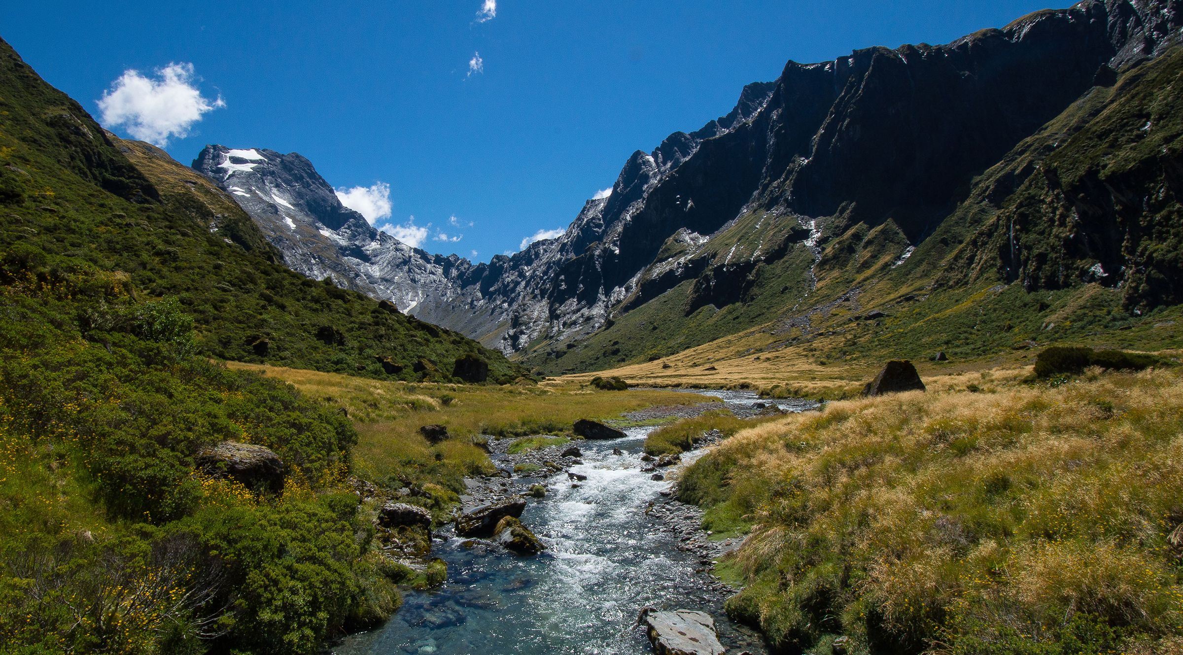
It is also home to some dramatic walks, none more so than the Border Track, a challenging 21km one-way route that traverses rough and remote territory and connects the Green Mountains and Binna Burra, the two entry points for visitors to the park and the only sources of tourist information, refreshments and a variety of accommodation.
The Green Mountains plateau is home to O’Reilly’s Rainforest Retreat, much developed since its origins in 1926 when Tom O’Reilly recognised that tourism was likely to be more profitable than dairy farming and opened the first guesthouse. The O’Reilly family still runs the Green Mountains tourism operation and the hotel has been joined by tearooms and a rustic bar, modern eco-friendly villas and even a vineyard.
The Border Track passes through warm temperate, cool temperate and cool sub-tropical rainforest, passing a series of lookouts perched above the steep slopes dropping into the Tweed caldera and traversing stands of gnarled, moss-covered Antarctic beech, here at their most northerly extent in Australia. Relict bird and reptile species, marooned here by historic climate change, include the angle-headed dragon and the extraordinary Albert’s lyrebird, a notoriously shy bird famous for its impressively ornate tail feathers, elaborate courtship displays and mimicry of other birds.
There are many other iconic walks in Lamington, and two that come highly recommended are the Python Rock track at O’Reilly's, which leads through rainforest frequented by exotic birds such as the paradise riflebird, velvety black with a splash of iridescent blue on the breast, to a viewpoint overlooking the Lost World, Moran’s Falls and, in the distance, the volcanic peak of Mount Lindsay; and the Ship’s Stern circuit at Binna Burra, a long but rewarding walk past lava cliffs studded with caves and across creeks to a series of lookouts offering views of the scenic Numinbah valley, the distinctive tiered profile of Mount Warning and, a long way to the north, the city of Brisbane.
The Caves Circuit
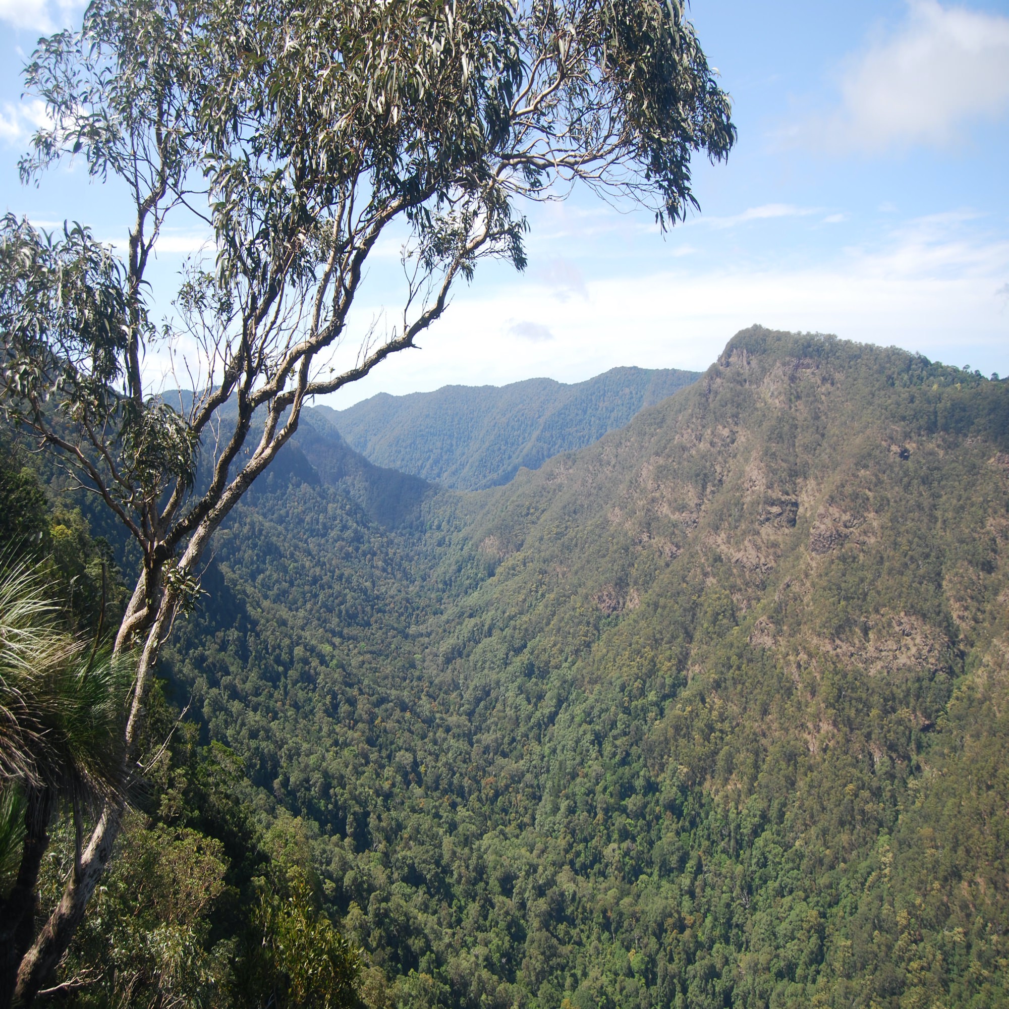
But for an ideal introduction to the diverse landscapes and stunning wildlife of the area, starting right by the visitor centre at Binna Burra, it’s hard to beat the Caves Circuit – a mere 6km but it feels longer, with rough tracks, a long downhill section and a stiff climb back out of the Coomera valley to the Binna Burra plateau.
In its early stages the trail alternates between dry eucalypt forest on exposed headlands, with trees such as Sydney blue gum, tallowwood and stringy bark to the fore, and rainforest species in the gullies. There's plenty of evidence of rainforest succession, with strangler figs enveloping the trunks of brush box trees; the fig uses the host tree for support but eventually overpowers and replaces it.
Open eucalypt woodland follows, with increasingly spectacular views north to the thickly forested slopes of Mount Tamborine, north-west along the deep Coomera valley and west to the Darlington Range, with classic hoop pines protruding above the woodland canopy. The brilliant white of sulphur-crested cockatoos punctuates the green canopy as they search for mature cones in the pines.
Male Regent bowerbirds with their even more spectacular yellow and black plumage are regularly seen just below the track, and there is a chance of seeing koalas tucked high into a fork of a trackside tree.
There's a glimpse of the rushing Coomera river far below, with its big swimming pools a favourite haunt of eels. The Old Cedar Road – nowadays just a rough track – alongside the river was constructed by loggers looking to extract red cedars (especially prized for cabinet-making) but had already been abandoned by the 1880s. There are still cedars by the river, but the dazzling red of summer is supplied by flame trees bursting into flower.
Beyond a seat with a great view of the narrowing Coomera gorge to the south, together with a plaque commemorating Robert Collins, one of pioneers of the national park movement in Australia, the gradient increases and the path is now stepped as it descends the cliffs, with flowering shrubs such as tea-tree and wattle alongside. The route now passes through a short tunnel cut through volcanic breccia and descends rock and then concrete steps to arrive at the deeply impressive Kweebani Cave – an overhanging rock face exposing three different rock types from the Tweed volcano.
The ceiling of the overhang comprises a layer of tuff (compacted volcanic ash), the upper reaches are formed of angular fragments known as breccia, and at the base is a classic exposure of the smooth black rock glass known as perlite. The rock overhang was used for shelter by the Wangerriburra people and the discovery of charcoal and bone fragments – from pademelons, a small wallaby-like marsupial, as well as possums, carpet pythons and crayfish – has confirmed the use of the area for cooking; indeed Kweebani means ‘I cook’ in the local Yugambeh language. It’s likely that the shelter was in use for at least 6000 years.
The return from the cave to Binna Burra initially passes through more sub-tropical rainforest, with the track picking its way through a stand of hoop pines and then crossing Barrabareen Creek in its rocky gully, with colonies of orchids and epiphytes such as crow’s nest and staghorn ferns in close attendance. Beyond a huge red cedar, the forest becomes more open and the birdlife increases, with a good chance of seeing species such as the fan-tailed cuckoo and a variety of honeyeaters including the colourful eastern spinebill. It’s also worth keeping a lookout for pieces of apparently discarded blue plastic on the forest floor: the satin bowerbird collects these to attract females into its bower.
The path zigzags steeply uphill, passing clearings where fallen trees have allowed light through the canopy and stimulated the growth of stinging trees (don’t touch!), vines and native raspberry, and then abruptly arrives at a big grassy clearing, a shock after the enclosure of the forest. Old fencing here marks the site of the original paddock where horses turned the wheel operating the ‘flying fox’, which hauled supplies to Binna Burra until the road was finally completed in time for Christmas 1946.
The tearoom lies to the right here, while the walk continues to the left, downhill along the Beechmont road to the visitor centre with good views on the way of the cone-shaped volcanic plug of Egg Rock, an important indigenous site, and beyond it the massive Hinze Dam reservoir and the skyscrapers of the northern Gold Coast.
West Canungra Creek Circuit
For something rather more challenging, a favourite option is one of the longer tracks starting at O’Reilly’s, such as the West Canungra Creek Circuit, a serious expedition of around 14km on a reasonably good track, with a steady descent, a number of creek crossings and a steep climb back to the plateau. An early start is recommended for this and similar walks, together with sunscreen, food and plenty of water. The track was reopened in early 2019 following repairs to the extensive damage caused in the aftermath of tropical cyclone Debbie in 2017 – the latest in a series of extreme weather events featuring storms, fire and drought.
The route briefly follows the Border Track, then doubles back and descends steadily, often on stone steps, to traverse warm sub-tropical rainforest with red cedars, fig and rosewood trees.
The sounds of the rainforest are very evident here – not just the harsh screeches that pass for birdsong in Australia but also the disturbingly realistic cat-like cries of the green catbird.
After crossing Darraboola Creek on a little bridge, the descent continues on a graded track passing the occasional landslip until the track meets West Canungra Creek at Yerralahla, the Blue Pool. This is a delightful spot, a miniature lake with a small waterfall, where several large eels live and feed; they’re worth seeing but can bite when threatened. Platypus are also regularly spotted here and in some of the other deeper pools, together with the endemic Lamington blue spiny crayfish, which can sometimes be heard snapping and hissing close to the water.
The walk now follows the creek upstream, with no fewer than nine crossings of the main and subsidiary creeks, some of them awkward on greasy angular boulders colonised by algae, others easy except after significant rainfall (when the route is of course at its most spectacular, with white water coursing down the cataracts and crashing over the falls). This is serious walking since a couple of the creek crossings are none too obvious and it pays to take a measured approach, looking for the exit on the far bank: sometimes, although not always, an orange marker on a tree indicates the exit route.
It’s very much worth taking the time to drink in the scenery, with the rocky creek bed interspersed with little pools and miniature cascades such as the Wongaree Falls; many locals regard this is one of the loveliest sections of walking trail in the whole of Lamington.
Perhaps the optimum time to visit is in December or January, when the delicate white Christmas orchids are in flower; at the same time there may be more startling sights, such as pythons or small black red-bellied snakes sunning themselves on warm boulders. Here, as elsewhere on the walk, there will be much rustling in the undergrowth, perhaps betraying the presence of a skulking, cryptically marked Australian logrunner, or maybe something rather larger – a lace monitor lizard slithering away from danger, or even a red-necked pademelon hopping into the understorey. Despite their size, lace monitors are a prey species for raptors such as wedge-tailed eagles, and they were taken by Aboriginal peoples both for food and as a source of medicines.
A big rock face above the track, composed of a volcanic mixture of rhyolite, tuff and perlite, signals the end of the creekside walking. The junction with the Box Forest circuit here is well signposted; both routes now lie to the right, gaining height through the rainforest on the return to the Green Mountains plateau, with brush box trees, Piccabeen palms and walking-stick palms to the fore, and plenty of tree ferns adding to the steamy forest atmosphere.
A final sustained climb on a well-used, wide path eventually levels out to reach the plateau at another welcome signpost where the Border Track comes in from the left. The canopy is quite oppressive here, particularly around a stand of venerable Antarctic beech trees, then opens out somewhat as the track passes some strangler figs and a variety of trees helpfully labelled to aid identification. The final section of the route is very easy on a highly popular level track, latterly on tarmac, which soon reaches a big clearing next to O’Reilly’s guesthouse and its bar and tearoom.
Update: July 2020
The devastating bushfires which destroyed much of the Binna Burra complex in September 2019 also left the only access road, from Beechmont south to Binna Burra, in a dangerously unsafe condition, with hazardous trees and unstable boulders on cliff faces above the road. Extensive repairs have been carried out and it is now expected that the road, and most of the walking tracks, will reopen in September 2020.