The Karnischer Höhenweg – a walk through history
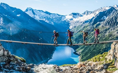
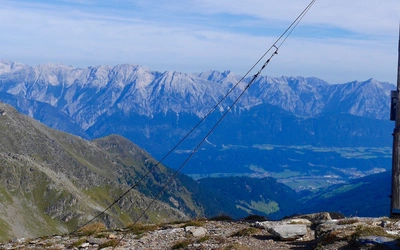
The Karnischer Höhenweg is a 170km waymarked hut-to-hut trek along the border between Italy and Austria. Also known as the Carnic Peace Trail, it runs west to east along the ridge of the Carnic Alps, the site of the WW1 front line. Here's what you need to know.
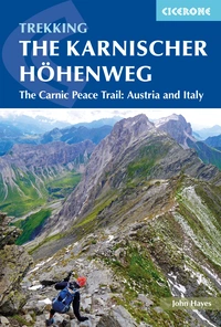
The Karnischer Hohenweg
A 1-2 week trek on the Carnic Peace Trail: Austria and Italy
£15.95
English-language guidebook to the Karnischer Höhenweg, a 170km waymarked hut-to-hut trek along the border between Italy and Austria. Also known as the Carnic Peace Trail, it runs west to east along the ridge of the Carnic Alps, the site of the WW1 front line. With information on planning your trip, accommodation and the history of the area.
More information| What? | The Karnischer Hohenweg |
| Also referred to as? | The Carnic Peace Trail |
| Where? | Following the World War I front line through the Carnic Alps, along the border of Austria and Italy, sandwiched between the Hohe Tauern to the north and Dolomites to the south. |
| When was it established? | In the 1970s to commemorate WW1 – restoring wartime remains and making them accessible to visitors was an important act of reconciliation. Reminders of the conflict are everywhere, with trench works and barbed wire still in situ despite the passage of 100 years. |
| Start point? | Sillian |
| End point? | Thörl-Maglern |
| How long is the route? | 170km |
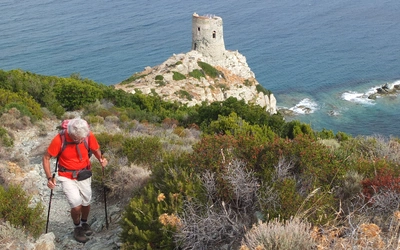
| How long to complete? | 1–2 weeks. The walk takes a minimum of eight days to complete, but most people will want longer, particularly if the highly recommended Italian variant is followed. To make the most of the Karnischer Höhenweg, including going up some of the optional summits, then spending a fortnight's holiday in the Carnic Alps makes sense. |
| How many stages are there? | 8 stages in both the Austrian and Italian variants. |
| How long are the stages? | Stages range from 6.3 to 28km |
| Which direction to walk in? | The route is traditionally walked from west to east. |
| How fit do I need to be? | A reasonable level of fitness and a head for heights is required. There are a few places where steel cables and ladders need to be negotiated but these don't require any special equipment or technical expertise. |
| What time of year? | The Karnischer Höhenweg is a high Alpine trek and can only be walked in the summer between mid-July and the end of September. |
| Key centres? | A linear ridge walk, the Karnischer Höhenweg starts at Sillian in the west and ends near Arnoldstein in the east, and crosses major road passes at Plöckenpass and Nassfeld. |
| What accommodation is there? | To walk the whole route involves staying in a mix of mountain huts and small hotels, although a strongly recommended option involves a couple of nights in farm stays, known in Italy as agriturismo. This interesting and varied ‘package’ forms a key part of the Karnischer Höhenweg experience. |
| Is the route waymarked? | The Karnischer Höhenweg is a clearly waymarked and well-supported high-altitude trek. |
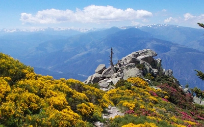
| Route highlights? | First World War remains; the open-air museum at the Plöckenpass; views of the Dolomites, Hohe Tauern and Julian Alps; the unique geology of the Carnic Alps UNESCO geopark; Monte Coglians - the highest summit in the Carnic Alps and home to the Peace Bell. |
| Fun fact? | There are two cheese making farms, one in Italy and one in Austria, where you can stay overnight. Both win awards for their cheese. |
Austrian route – 8 days – stage summary
| Stage | Time | Distance (km) | Ascent/descent (m) |
|---|---|---|---|
| Stage 1: Arnbach to Obstanserseehütte | 8hr 45min | 18.3 | 1900/550 |
| Stage 2: Obstanserseehütte to Porzehütte | 6hr 30min | 12.2 | 740/110 |
| Stage 3: Porzehütte to Hochweißsteinhaus | 8hr | 17.8 | 1180/1240 |
| Stage 4: Hochweißsteinhaus to Gasthof Valentinalm | 9hr | 23.2 | 1180/1820 |
| Stage 5: Gasthof Valentinalm to Zollnerseehütte | 7hr 30min | 19 | 1440/950 |
| Stage 6: Zollnerseehütte to Alpenhof Plattner | 8hr 20min | 23.8 | 970/1080 |
| Stage 7: Alpenhof Plattner to Gasthaus Starhand | 8hr 20min | 26.6 | 1100/1270 |
| Stage 8: Gasthaus Starhand to Arnoldstein | 8hr 30min | 28 | 1100/1800 |
| Total | approx. 65hr | 168.9 | 9610/8820 |
Italian route – 10 days – stage summary
| Stage | Time | Distance (km) | Ascent/descent (m) |
|---|---|---|---|
| Stage 1: Arnbach to Obstanserseehütte | 8hr 45min | 18.3 | 1900/550 |
| Stage 2: Obstanserseehütte to Porzehütte | 6hr 30min | 12.2 | 740/110 |
| Stage 3: Porzehütte to Hochweißsteinhaus | 8hr | 17.8 | 1180/1240 |
| Stage 4A: Hochweißsteinhaus to Rifugio Marinelli | 8hr 50min | 19.9 | 1360/1100 |
| Stage 5A: Rifugio Marinelli to Plöckenpass | 2hr 15min | 6.3 | 100/760 |
| Stage 5B: Plöckenpass to Casera Pramosio | 7hr 15min | 11.2 | 1300/1030 |
| Stage 5C: Casera Pramosio to Zollnerseehütte | 3hr | 7 | 700/500 |
| Stage 6: Zollnerseehütte to Alpenhof Plattner | 8hr 20min | 23.8 | 970/1080 |
| Stage 7: Alpenhof Plattner to Gasthaus Starhand | 8hr 20min | 26.6 | 1100/1270 |
| Stage 8: Gasthaus Starhand to Arnoldstein | 8hr 30min | 28 | 1100/1800 |
| Total | approx. 70hr | 171.1 | 10,450/9440 |
Personal experience...
I first heard about the Karnischer Höhenweg eight years ago. After a stormy, snowy day in Austria’s Eastern Alps (it was the middle of August), we were enjoying the shelter, warmth, and conviviality of a mountain hut. Crowded around an unseasonal fire, the conversation turned to trips we’d done and favorite hikes.
Four young Austrians from Vienna described a hike they’d enjoyed the previous year. Their description of a long ridge walk, high above the trees, which switched between Austria and Italy, convinced us that it was a walk we had to do.
I've now walked the Karnischer Höhenweg three times. The first was as part of a longer trek along the Via Alpina, and the second two more recently after I had convinced Cicerone that the walk deserved a guidebook. Each occasion was a pleasure and added further layers of understanding and enjoyment to what is a particularly interesting, as well as beautiful, part of the world.
Personally, I enjoy walking through landscapes where the history talks, but you don't need to be interested in history to enjoy the Karnischer Höhenweg.
On two of my trips, I walked the Karnischer Höhenweg with my wife, Christine, but the third time I was on my own. If you’re a solo hiker but appreciate some occasional company, you will not be disappointed. It’s a popular walk with Germans and Austrians, and walking on a similar schedule, you’re likely to bump into the same people each evening. It’s a very sociable experience, and to be honest, you’ll probably meet more people walking alone than as a couple.
If I have one regret, it’s that I didn’t keep in touch with those Austrians we spent a very pleasant evening with eight years ago. Their enthusiasm meant that I got to learn about and enjoy a special part of the world that I wouldn’t otherwise have visited. It would be nice to spend another evening with them in another hut someday and share our memories.
John Hayes, guidebook author
The Karnischer Hohenweg
A 1-2 week trek on the Carnic Peace Trail: Austria and Italy
£15.95
English-language guidebook to the Karnischer Höhenweg, a 170km waymarked hut-to-hut trek along the border between Italy and Austria. Also known as the Carnic Peace Trail, it runs west to east along the ridge of the Carnic Alps, the site of the WW1 front line. With information on planning your trip, accommodation and the history of the area.
More information